科罗拉多州丹佛市的高分辨率多污染物地图
IF 3.4
Q2 ENVIRONMENTAL SCIENCES
引用次数: 0
摘要
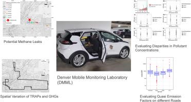
在城市环境中,确定对健康有重大影响的交通相关空气污染物(TRAPs)和温室气体(GHGs)的特征可能具有挑战性。移动监测有可能捕捉到这些污染物的空间分布。我们介绍了2023年夏天使用丹佛移动监测实验室(DMML)在科罗拉多州丹佛市测量超细颗粒(ufp)、黑碳(BC)、臭氧(O3)、甲烷(CH4)和二氧化碳(CO2)浓度的活动结果。尽管我们的活动很短暂,但我们获得了几个有趣的结果。我们观察到主要道路上UFP和BC浓度升高。相比之下,商业城附近街道和道路以及工业区的O3浓度较高。我们在I-70高速公路上持续观察到CH4浓度升高(>2.5 ppm),这表明存在以前未知的CH4主要来源。在我们的活动中测量的CH4浓度与重叠的空中活动的浓度不一致,这表明移动监测对于捕获城市中重要的、可能间歇性的CH4热点至关重要。我们评估了树木是否减轻了污染浓度,因为植树是丹佛市的一项关键政策倡议。使用线性混合效应回归模型,我们发现树冠覆盖度与ufp、BC和CH4呈显著负相关,与O3呈正相关。我们的工作强调了调查树冠覆盖率在减少陷阱中的作用的重要性。本文章由计算机程序翻译,如有差异,请以英文原文为准。
High-resolution multi-pollutant mapping in Denver, Colorado
Characterizing traffic-related air pollutants (TRAPs), which significantly impact health, and greenhouse gases (GHGs) can be challenging in urban environments. Mobile monitoring has the potential to capture the spatial distribution of these pollutants. We present results from a campaign using the Denver Mobile Monitoring Laboratory (DMML) in the summer of 2023 when we measured ultrafine particles (UFPs), black carbon (BC), ozone (O3), methane (CH4), and carbon dioxide (CO2) concentrations in Denver, CO. Despite our campaign being brief, we obtained several interesting results. We observed elevated UFP and BC concentrations on major roads. In contrast, O3 concentrations were higher on neighborhood streets and roads and in the industrial neighborhood of Commerce City. We consistently observed elevated CH4 concentrations (>2.5 ppm) on highway I-70, suggesting the presence of a previously unknown major source of CH4. The CH4 concentrations measured in our campaign did not align with those from an overlapping aerial campaign, suggesting that mobile monitoring is crucial to capture important, potentially intermittent CH4 hotspots in cities. We evaluated if trees mitigated pollution concentrations, as planting trees is a key policy initiative of the city of Denver. We observed significant negative associations between tree canopy coverage and UFPs, BC, and CH4, and a positive association with O3 when using linear mixed-effects regression models. Our work highlights the importance of investigating the role of tree canopy coverage to mitigate TRAPs.
求助全文
通过发布文献求助,成功后即可免费获取论文全文。
去求助
来源期刊
Atmospheric Environment: X
Environmental Science-Environmental Science (all)
CiteScore
8.00
自引率
0.00%
发文量
47
审稿时长
12 weeks
 求助内容:
求助内容: 应助结果提醒方式:


