对比河道宽度和海岸线复杂性的长期趋势

IF 3.1 2区 地球科学 Q2 GEOGRAPHY, PHYSICAL
Elizabeth R. Skaggs , Jonathan M. Friedman , Christopher Holmquist-Johnson
{"title":"对比河道宽度和海岸线复杂性的长期趋势","authors":"Elizabeth R. Skaggs ,&nbsp;Jonathan M. Friedman ,&nbsp;Christopher Holmquist-Johnson","doi":"10.1016/j.geomorph.2025.109978","DOIUrl":null,"url":null,"abstract":"<div><div>Drought and reservoir management in the Colorado River Watershed have decreased peak flows, reducing the ability of rivers to erode their banks and remove encroaching vegetation. Multiple studies have documented the resulting decrease in channel width, but less attention has been paid to long-term trends in shoreline complexity, including the number and size of islands. We used a sequence of aerial photographs and satellite images collected in 13 different years to measure decadal trends in channel width and shoreline complexity for the Gray Canyon segment of the Green River, Utah. Between 1938 and 2021 peak flows decreased by 34 % and channel width decreased by 18 %, confirming observations of decreasing width in response to decreasing flows from elsewhere in the watershed. Over the same period, however, shoreline complexity increased by 5.5 % and the number of islands almost tripled, indicating that merging of islands into the encroaching floodplain was outpaced by formation and growth of new islands. The increase in shoreline complexity occurred between 1938 and 2006. No further net increase has been observed since 2006, suggesting that room for new island formation could now be limited in the narrower channel. Sequences of channel delineations already mapped to quantify long-term changes in channel width at other sites could be used to determine whether the increases in shoreline complexity we observed at Gray Canyon also occur elsewhere.</div></div>","PeriodicalId":55115,"journal":{"name":"Geomorphology","volume":"489 ","pages":"Article 109978"},"PeriodicalIF":3.1000,"publicationDate":"2025-08-23","publicationTypes":"Journal Article","fieldsOfStudy":null,"isOpenAccess":false,"openAccessPdf":"","citationCount":"0","resultStr":"{\"title\":\"Contrasting long-term trends in channel width and shoreline complexity\",\"authors\":\"Elizabeth R. Skaggs ,&nbsp;Jonathan M. Friedman ,&nbsp;Christopher Holmquist-Johnson\",\"doi\":\"10.1016/j.geomorph.2025.109978\",\"DOIUrl\":null,\"url\":null,\"abstract\":\"<div><div>Drought and reservoir management in the Colorado River Watershed have decreased peak flows, reducing the ability of rivers to erode their banks and remove encroaching vegetation. Multiple studies have documented the resulting decrease in channel width, but less attention has been paid to long-term trends in shoreline complexity, including the number and size of islands. We used a sequence of aerial photographs and satellite images collected in 13 different years to measure decadal trends in channel width and shoreline complexity for the Gray Canyon segment of the Green River, Utah. Between 1938 and 2021 peak flows decreased by 34 % and channel width decreased by 18 %, confirming observations of decreasing width in response to decreasing flows from elsewhere in the watershed. Over the same period, however, shoreline complexity increased by 5.5 % and the number of islands almost tripled, indicating that merging of islands into the encroaching floodplain was outpaced by formation and growth of new islands. The increase in shoreline complexity occurred between 1938 and 2006. No further net increase has been observed since 2006, suggesting that room for new island formation could now be limited in the narrower channel. Sequences of channel delineations already mapped to quantify long-term changes in channel width at other sites could be used to determine whether the increases in shoreline complexity we observed at Gray Canyon also occur elsewhere.</div></div>\",\"PeriodicalId\":55115,\"journal\":{\"name\":\"Geomorphology\",\"volume\":\"489 \",\"pages\":\"Article 109978\"},\"PeriodicalIF\":3.1000,\"publicationDate\":\"2025-08-23\",\"publicationTypes\":\"Journal Article\",\"fieldsOfStudy\":null,\"isOpenAccess\":false,\"openAccessPdf\":\"\",\"citationCount\":\"0\",\"resultStr\":null,\"platform\":\"Semanticscholar\",\"paperid\":null,\"PeriodicalName\":\"Geomorphology\",\"FirstCategoryId\":\"89\",\"ListUrlMain\":\"https://www.sciencedirect.com/science/article/pii/S0169555X25003885\",\"RegionNum\":2,\"RegionCategory\":\"地球科学\",\"ArticlePicture\":[],\"TitleCN\":null,\"AbstractTextCN\":null,\"PMCID\":null,\"EPubDate\":\"\",\"PubModel\":\"\",\"JCR\":\"Q2\",\"JCRName\":\"GEOGRAPHY, PHYSICAL\",\"Score\":null,\"Total\":0}","platform":"Semanticscholar","paperid":null,"PeriodicalName":"Geomorphology","FirstCategoryId":"89","ListUrlMain":"https://www.sciencedirect.com/science/article/pii/S0169555X25003885","RegionNum":2,"RegionCategory":"地球科学","ArticlePicture":[],"TitleCN":null,"AbstractTextCN":null,"PMCID":null,"EPubDate":"","PubModel":"","JCR":"Q2","JCRName":"GEOGRAPHY, PHYSICAL","Score":null,"Total":0}
引用次数: 0

摘要

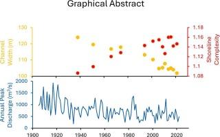
科罗拉多河流域的干旱和水库管理减少了峰值流量,降低了河流侵蚀河岸和清除入侵植被的能力。多项研究已经记录了海峡宽度的减少,但很少有人关注海岸线复杂性的长期趋势,包括岛屿的数量和大小。我们使用了在13个不同年份收集的一系列航空照片和卫星图像来测量犹他州格林河灰色峡谷段的河道宽度和海岸线复杂性的年代际趋势。1938年至2021年间,峰值流量减少了34%,河道宽度减少了18%,这证实了流域其他地方流量减少导致河道宽度减少的观测结果。然而,在同一时期,海岸线的复杂性增加了5.5%,岛屿的数量几乎增加了两倍,这表明岛屿向侵蚀的洪泛平原合并的速度超过了新岛屿的形成和增长。海岸线复杂性的增加发生在1938年至2006年之间。自2006年以来,没有观察到进一步的净增长,这表明在较窄的海峡中,新岛屿形成的空间可能受到限制。已经绘制的水道描绘序列可以量化其他地点的水道宽度的长期变化,可以用来确定我们在格雷峡谷观察到的海岸线复杂性的增加是否也发生在其他地方。
本文章由计算机程序翻译,如有差异,请以英文原文为准。

Contrasting long-term trends in channel width and shoreline complexity

Contrasting long-term trends in channel width and shoreline complexity
Drought and reservoir management in the Colorado River Watershed have decreased peak flows, reducing the ability of rivers to erode their banks and remove encroaching vegetation. Multiple studies have documented the resulting decrease in channel width, but less attention has been paid to long-term trends in shoreline complexity, including the number and size of islands. We used a sequence of aerial photographs and satellite images collected in 13 different years to measure decadal trends in channel width and shoreline complexity for the Gray Canyon segment of the Green River, Utah. Between 1938 and 2021 peak flows decreased by 34 % and channel width decreased by 18 %, confirming observations of decreasing width in response to decreasing flows from elsewhere in the watershed. Over the same period, however, shoreline complexity increased by 5.5 % and the number of islands almost tripled, indicating that merging of islands into the encroaching floodplain was outpaced by formation and growth of new islands. The increase in shoreline complexity occurred between 1938 and 2006. No further net increase has been observed since 2006, suggesting that room for new island formation could now be limited in the narrower channel. Sequences of channel delineations already mapped to quantify long-term changes in channel width at other sites could be used to determine whether the increases in shoreline complexity we observed at Gray Canyon also occur elsewhere.
求助全文
通过发布文献求助,成功后即可免费获取论文全文。 去求助
来源期刊
Geomorphology
Geomorphology 地学-地球科学综合
CiteScore
8.00
自引率
10.30%
发文量
309
审稿时长
3.4 months
期刊介绍: Our journal''s scope includes geomorphic themes of: tectonics and regional structure; glacial processes and landforms; fluvial sequences, Quaternary environmental change and dating; fluvial processes and landforms; mass movement, slopes and periglacial processes; hillslopes and soil erosion; weathering, karst and soils; aeolian processes and landforms, coastal dunes and arid environments; coastal and marine processes, estuaries and lakes; modelling, theoretical and quantitative geomorphology; DEM, GIS and remote sensing methods and applications; hazards, applied and planetary geomorphology; and volcanics.
×
引用
GB/T 7714-2015
复制
MLA
复制
APA
复制
导出至
BibTeX EndNote RefMan NoteFirst NoteExpress
×
提示
您的信息不完整,为了账户安全,请先补充。
现在去补充
×
提示
您因"违规操作"
具体请查看互助需知
我知道了
×
提示
确定
请完成安全验证×
copy
已复制链接
快去分享给好友吧!
我知道了
右上角分享
点击右上角分享
0
联系我们:info@booksci.cn Book学术提供免费学术资源搜索服务,方便国内外学者检索中英文文献。致力于提供最便捷和优质的服务体验。 Copyright © 2023 布克学术 All rights reserved.
京ICP备2023020795号-1
ghs 京公网安备 11010802042870号
Book学术文献互助
Book学术文献互助群
群 号:604180095
Book学术官方微信