由全球定位系统(GPS)观测推断的苏门答腊断层系统(SFS) Ketahun段现今地震间速度和断层滑动率
IF 2.6
3区 地球科学
Q2 GEOCHEMISTRY & GEOPHYSICS
引用次数: 0
摘要
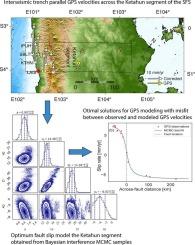
苏门答腊断裂系统(SFS)的克塔浑段是一个独特的构造活跃段,但其滑动速率尚不为人所知。克塔洪板块在1946年和1952年分别经历了两次7.6级和6.8级的大地震。利用全球定位系统(GPS)数据,利用位错弹性模型,利用Metropolis马尔可夫链蒙特卡罗(MCMC)采样器的贝叶斯方法来估计最佳断层参数,从而更好地估计滑移率。然后,我们确定了存储在分段上的累积能量的潜在量。我们使用GAMIT/GLOBK软件处理了2018-2024年间来自GIA、SuGAr和UNIB网络的35个GPS站的原始GPS数据。将GPS日解约束到ITRF-2014框架中,并将GPS速度转换成Sunda块。在模拟海沟平行GPS速度之前,我们尝试校正2007年m8.4 Bengkulu地震造成的粘弹性速度,并考虑到大逆冲耦合对海沟平行GPS速度的影响。在我们的分析中,我们发现粘弹性响应和大推力耦合效应的重要性,提供了更好的滑移率和锁紧深度估计。我们的结果推断,在Ketahun段,估计断层滑动速率为14.5[−1.2,+1.3]mm/yr,锁定深度为14.4[−4.9,+4.8]km。如果每50至200 年发生一次地震,该段可以产生6至7级以上的地震。本文章由计算机程序翻译,如有差异,请以英文原文为准。
Present-day inter-seismic velocities and fault slip rate of Ketahun segment, Sumatran Fault System (SFS) inferred from Global Positioning System (GPS) observations
The Ketahun segment of the Sumatran Fault System (SFS) is distinctive and tectonically active segment, yet the slip rate of the segment is not widely known. The Ketahun segment underwent two major earthquakes of Ms 7.6 in 1946 and Ms 6.8 in 1952, respectively. Using Global Positioning System (GPS) data, we aim to better estimate the slip rates using a dislocation elastic model following a Bayesian approach with Metropolis Markov chain Monte Carlo (MCMC) samplers to estimate optimum fault parameters. Then we determined the potential amount of cumulative energy stored at the segment. We processed raw GPS data from 35 GPS stations, combining from GIA, SuGAr, and UNIB networks during 2018–2024 using GAMIT/GLOBK software. The daily GPS solutions were constrained into the ITRF-2014 frame, and the GPS velocities were translated into Sunda block. Before we model the trench parallel GPS velocities, we attempted to correct the viscoelastic velocities due to the 2007 Mw 8.4 Bengkulu earthquake incorporating the effect of megathrust coupling on the trench parallel GPS velocities. We find the importance of viscoelastic response and megathrust coupling effect in our analysis, providing better slip rate and locking depth estimation. Our result inferred that the estimated fault slip rate is 14.5 [−1.2, +1.3] mm/yr with a locking depth of 14.4 [−4.9, +4.8] km across in the Ketahun segment. The segment is capable of generating a magnitude ∼6 to 7+ if a single earthquake occurs every 50 to 200 years.
求助全文
通过发布文献求助,成功后即可免费获取论文全文。
去求助
来源期刊

Tectonophysics
地学-地球化学与地球物理
CiteScore
4.90
自引率
6.90%
发文量
300
审稿时长
6 months
期刊介绍:
The prime focus of Tectonophysics will be high-impact original research and reviews in the fields of kinematics, structure, composition, and dynamics of the solid arth at all scales. Tectonophysics particularly encourages submission of papers based on the integration of a multitude of geophysical, geological, geochemical, geodynamic, and geotectonic methods
 求助内容:
求助内容: 应助结果提醒方式:


