利用遥感和人工智能模型预测波斯湾的有害藻华
IF 2.9
4区 地球科学
Q2 MARINE & FRESHWATER BIOLOGY
引用次数: 0
摘要
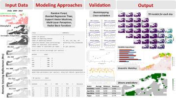
有害藻华(HABs)对整个波斯湾地区的环境和社会经济构成重大威胁,影响海洋生态系统、公众健康和沿海经济。该研究展示了一种先进的预测管道,该管道使用卫星遥感数据和集成人工智能(AI)建模来预测阿巴斯港、格什姆和霍尔木兹沿岸的赤潮事件。利用MODIS-Aqua遥感影像提取了412、443、488、513和555 nm波段的叶绿素-a浓度、海表温度(SST)和遥感反射率(Rrs)等关键环境变量,提供了海洋环境时空变化的综合描述。我们采用了一种物种分布建模方法,该方法集成了五种机器学习(ML)算法——随机森林(RF)、增强回归树(BRT)、支持向量机(SVM)、多层感知器(MLP)和径向基函数(RBF)——以减轻单模型预测的局限性,提高预测的可靠性。我们的建模框架利用了1809个已确认的赤潮存在观测值和13396个系统生成的伪缺失点,并通过在713个每日预测间隔内的自助和交叉验证验证了模型的性能。集合模型通过AUC加权的个体预测聚合而成,实现了平均曲线下面积(AUC)为0.95,峰值真实技能统计(TSS)为0.85。具体而言,2008年11月23日的一项案例研究显示,该模型的灵敏度为96.67%,特异性为74.37%,表明该模型在正确识别HAB事件方面非常熟练。可变重要性图将海温和某些Rrs波段(特别是443和555nm)作为关键预测因子,这与藻类生长的既定驱动因素一致。此外,这种耦合方法不仅可以对水华事件进行高分辨率的时空预测,还可以深入了解有害藻华动态的环境机制,为有效的沿海治理和政策制定提供信息。总的来说,这些发现表明,将遥感数据与集成人工智能方法相结合,可以创建有效的预警系统,并为有针对性的管理实践提供信息,以减少波斯湾赤潮的影响。本文章由计算机程序翻译,如有差异,请以英文原文为准。
Prediction of harmful algal blooms in the Persian Gulf using remote sensing and artificial intelligence modeling
Harmful algal blooms (HABs) represent a significant environmental and socio-economic threat across the Persian Gulf region, impacting marine ecosystems, public health, and coastal economies. This study shows an advanced predictive pipeline that uses satellite remote sensing data with ensemble Artificial intelligence (AI) modeling to forecast HAB events along the coastlines of Bandar Abbas, Qeshm, and Hormuz. Key environmental variables, including chlorophyll-a concentration, sea surface temperature (SST), and remote sensing reflectance (Rrs) at wavelengths of 412, 443, 488, 513, and 555 nm, were extracted from MODIS-Aqua imagery, providing a comprehensive depiction of the spatial and temporal variability in the marine environment. We employed a species distribution modeling approach that integrates an ensemble of five machine learning (ML) algorithms—Random Forest (RF), Boosted Regression Trees (BRT), Support Vector Machines (SVM), Multi-Layer Perceptron (MLP), and Radial Basis Function (RBF)—to mitigate the limitations of single-model predictions and enhance forecast reliability. Our modeling framework utilized 1809 confirmed HAB presence observations alongside 13,396 systematically generated pseudo-absence points, with model performance validated through bootstrapping and cross-validation over 713 daily prediction intervals. The ensemble model, formulated via AUC-weighted aggregation of individual predictions, achieved a robust average Area Under the Curve (AUC) of 0.95 and a peak True Skill Statistic (TSS) of 0.85. Specifically, a case study on November 23, 2008, yielded a sensitivity of 96.67 % and specificity of 74.37 %, highlighting the model's proficiency in correctly identifying HAB events. Variable importance plots pinned SST and certain Rrs bands (particularly at 443 and 555 nm) as key predictors, which concurs with established drivers of algal growth. Further, this coupled method not only yields high-resolution spatial and temporal forecasts of bloom events but also refined insight into environmental mechanisms underlying HAB dynamics, informing effective coastal governance and policy making. Collectively, these findings illustrate the promise of combining remote sensing data with ensemble AI methods to create effective early-warning systems and inform targeted management practices for reducing impacts of HABs in the Persian Gulf.
求助全文
通过发布文献求助,成功后即可免费获取论文全文。
去求助
来源期刊
Journal of Sea Research
地学-海洋学
CiteScore
3.20
自引率
5.00%
发文量
86
审稿时长
6-12 weeks
期刊介绍:
The Journal of Sea Research is an international and multidisciplinary periodical on marine research, with an emphasis on the functioning of marine ecosystems in coastal and shelf seas, including intertidal, estuarine and brackish environments. As several subdisciplines add to this aim, manuscripts are welcome from the fields of marine biology, marine chemistry, marine sedimentology and physical oceanography, provided they add to the understanding of ecosystem processes.
 求助内容:
求助内容: 应助结果提醒方式:


