印度南部Vaigai河流域景观演化与空间异质性的相对控制:区域意义与适用性

IF 8.9 1区 地球科学 Q1 GEOSCIENCES, MULTIDISCIPLINARY
K.J. Juni , M. Ramkumar , B. Venkateshwaran , D. Menier , M.J. Mathew , K. Balasubramani , N.A. Siddiqui
{"title":"印度南部Vaigai河流域景观演化与空间异质性的相对控制:区域意义与适用性","authors":"K.J. Juni ,&nbsp;M. Ramkumar ,&nbsp;B. Venkateshwaran ,&nbsp;D. Menier ,&nbsp;M.J. Mathew ,&nbsp;K. Balasubramani ,&nbsp;N.A. Siddiqui","doi":"10.1016/j.gsf.2025.102128","DOIUrl":null,"url":null,"abstract":"<div><div>Deciphering tectono-climatic-lithological and other controls over landscape evolution at variable spatiotemporal scales is paramount in natural resources management and development. We have systematically documented and analysed selected critical quantitative morphometric data, namely, asymmetry factor, hypsometric integral, hypsometric curve, drainage divide migration and normalised steepness index, in addition to the assessment of longitudinal profiles and knickpoints, for a unique morphological river basin, the Vaigai River Basin, located in southern India. The spatial variability of various controls of geomorphological characteristics of the basin is interpreted using these morphometric parameters and field data. Notable results include, predominance of a concave-up nature of the majority of the sub-basins, occurrence of a distinct convex zone in the upper part and a distinctly concave zone in the lower part of the basin, a range of symmetric to asymmetric topographic nature with very prominent asymmetry in the middle of the basin, highest normalised channel steepness in the northernmost sub-basin and insignificant and lesser steepness in the majority of the basin, evidence of north-easterly migration of drainage divides within the river basin, manifested by sub-basin boundaries and the alignment of the majority of the knickpoints parallel to the NE–SW trending Karur-Kambam-Painavu-Thrissur shear zone. The results cumulatively indicate that the Vaigai River that runs on an antecedent basin continues evolving, principally under the controls of regional Precambrian structures. Nevertheless, the evolution has been episodic and spatially varied. The resurgent tectonic influence is more pronounced in the northern and north-western parts of the basin, while the river capture and drainage divide migration are pronounced in the northeastern part, signifying the collective influence of tectonics and climate. On the contrary, the middle and lower reaches of the basin lack a soil-sediment-weathered zone, signifying the prevalence of an intense erosional phase of the river. This information, together with previously documented catastrophic flooding events and sediment accumulation, categorise the river basin as episodically active, and in a transient phase of evolution. While providing affirmative evidence for the previous regional geomorphological model, the interpretation of the continuum of inherited Precambrian structures in the present study implies that there are subtle spatial differences of lithological-climatological and structural controls within and among each of the sub-basins that need to be considered for any natural resources management at local to regional scales.</div></div>","PeriodicalId":12711,"journal":{"name":"Geoscience frontiers","volume":"16 6","pages":"Article 102128"},"PeriodicalIF":8.9000,"publicationDate":"2025-08-12","publicationTypes":"Journal Article","fieldsOfStudy":null,"isOpenAccess":false,"openAccessPdf":"","citationCount":"0","resultStr":"{\"title\":\"Disentangling relative controls of landscape evolution and spatial heterogeneity in the Vaigai River Basin, southern India: Regional implications and applicability\",\"authors\":\"K.J. Juni ,&nbsp;M. Ramkumar ,&nbsp;B. Venkateshwaran ,&nbsp;D. Menier ,&nbsp;M.J. Mathew ,&nbsp;K. Balasubramani ,&nbsp;N.A. Siddiqui\",\"doi\":\"10.1016/j.gsf.2025.102128\",\"DOIUrl\":null,\"url\":null,\"abstract\":\"<div><div>Deciphering tectono-climatic-lithological and other controls over landscape evolution at variable spatiotemporal scales is paramount in natural resources management and development. We have systematically documented and analysed selected critical quantitative morphometric data, namely, asymmetry factor, hypsometric integral, hypsometric curve, drainage divide migration and normalised steepness index, in addition to the assessment of longitudinal profiles and knickpoints, for a unique morphological river basin, the Vaigai River Basin, located in southern India. The spatial variability of various controls of geomorphological characteristics of the basin is interpreted using these morphometric parameters and field data. Notable results include, predominance of a concave-up nature of the majority of the sub-basins, occurrence of a distinct convex zone in the upper part and a distinctly concave zone in the lower part of the basin, a range of symmetric to asymmetric topographic nature with very prominent asymmetry in the middle of the basin, highest normalised channel steepness in the northernmost sub-basin and insignificant and lesser steepness in the majority of the basin, evidence of north-easterly migration of drainage divides within the river basin, manifested by sub-basin boundaries and the alignment of the majority of the knickpoints parallel to the NE–SW trending Karur-Kambam-Painavu-Thrissur shear zone. The results cumulatively indicate that the Vaigai River that runs on an antecedent basin continues evolving, principally under the controls of regional Precambrian structures. Nevertheless, the evolution has been episodic and spatially varied. The resurgent tectonic influence is more pronounced in the northern and north-western parts of the basin, while the river capture and drainage divide migration are pronounced in the northeastern part, signifying the collective influence of tectonics and climate. On the contrary, the middle and lower reaches of the basin lack a soil-sediment-weathered zone, signifying the prevalence of an intense erosional phase of the river. This information, together with previously documented catastrophic flooding events and sediment accumulation, categorise the river basin as episodically active, and in a transient phase of evolution. While providing affirmative evidence for the previous regional geomorphological model, the interpretation of the continuum of inherited Precambrian structures in the present study implies that there are subtle spatial differences of lithological-climatological and structural controls within and among each of the sub-basins that need to be considered for any natural resources management at local to regional scales.</div></div>\",\"PeriodicalId\":12711,\"journal\":{\"name\":\"Geoscience frontiers\",\"volume\":\"16 6\",\"pages\":\"Article 102128\"},\"PeriodicalIF\":8.9000,\"publicationDate\":\"2025-08-12\",\"publicationTypes\":\"Journal Article\",\"fieldsOfStudy\":null,\"isOpenAccess\":false,\"openAccessPdf\":\"\",\"citationCount\":\"0\",\"resultStr\":null,\"platform\":\"Semanticscholar\",\"paperid\":null,\"PeriodicalName\":\"Geoscience frontiers\",\"FirstCategoryId\":\"89\",\"ListUrlMain\":\"https://www.sciencedirect.com/science/article/pii/S1674987125001331\",\"RegionNum\":1,\"RegionCategory\":\"地球科学\",\"ArticlePicture\":[],\"TitleCN\":null,\"AbstractTextCN\":null,\"PMCID\":null,\"EPubDate\":\"\",\"PubModel\":\"\",\"JCR\":\"Q1\",\"JCRName\":\"GEOSCIENCES, MULTIDISCIPLINARY\",\"Score\":null,\"Total\":0}","platform":"Semanticscholar","paperid":null,"PeriodicalName":"Geoscience frontiers","FirstCategoryId":"89","ListUrlMain":"https://www.sciencedirect.com/science/article/pii/S1674987125001331","RegionNum":1,"RegionCategory":"地球科学","ArticlePicture":[],"TitleCN":null,"AbstractTextCN":null,"PMCID":null,"EPubDate":"","PubModel":"","JCR":"Q1","JCRName":"GEOSCIENCES, MULTIDISCIPLINARY","Score":null,"Total":0}
引用次数: 0

摘要

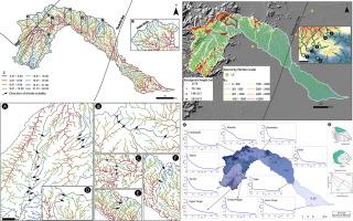
在不同时空尺度上破译构造-气候-岩性和其他对景观演化的控制在自然资源管理和开发中至关重要。我们系统地记录和分析了选择的关键定量形态测量数据,即不对称因子、半对称积分、半对称曲线、分水岭迁移和标准化陡峭度指数,以及纵向剖面和裂缝点的评估,这些数据都是针对印度南部的独特形态河流流域——Vaigai河流域。利用这些地貌测量参数和野外数据,解释了盆地地貌特征的各种控制因素的空间变异性。值得注意的结果包括:大多数子盆地以凹性为主,在盆地的上部出现明显的凸带,在盆地的下部出现明显的凹带,一系列对称到不对称的地形性质,盆地中部的不对称性非常突出,最北端子盆地的归一化河道陡峭度最高,而盆地的大部分陡峭度不明显或较小。流域内水系向东北迁移的证据,主要表现在次流域边界和大部分断裂带平行于北东-西南走向的karur - kamam - painavu - thrissur剪切带。综合研究结果表明,在前寒武纪构造的控制下,以前盆地为基础的瓦盖河在持续演化。然而,这种演变是断断续续的,在空间上是不同的。盆地北部和西北部的复兴构造影响较为明显,而东北部的河流捕获和流域分划迁移较为明显,表明构造和气候的共同影响。相反,盆地中下游缺乏土壤-沉积物-风化带,表明河流普遍存在强烈的侵蚀阶段。这些信息,连同先前记录的灾难性洪水事件和沉积物堆积,将河流流域归类为偶然活跃的,并且处于演化的短暂阶段。在为以前的区域地貌模式提供肯定证据的同时,本研究对继承的前寒武纪构造连续体的解释表明,每个子盆地内部和每个子盆地之间存在微妙的岩石-气候和构造控制的空间差异,这需要在局部到区域尺度上进行任何自然资源管理。
本文章由计算机程序翻译,如有差异,请以英文原文为准。

Disentangling relative controls of landscape evolution and spatial heterogeneity in the Vaigai River Basin, southern India: Regional implications and applicability

Disentangling relative controls of landscape evolution and spatial heterogeneity in the Vaigai River Basin, southern India: Regional implications and applicability
Deciphering tectono-climatic-lithological and other controls over landscape evolution at variable spatiotemporal scales is paramount in natural resources management and development. We have systematically documented and analysed selected critical quantitative morphometric data, namely, asymmetry factor, hypsometric integral, hypsometric curve, drainage divide migration and normalised steepness index, in addition to the assessment of longitudinal profiles and knickpoints, for a unique morphological river basin, the Vaigai River Basin, located in southern India. The spatial variability of various controls of geomorphological characteristics of the basin is interpreted using these morphometric parameters and field data. Notable results include, predominance of a concave-up nature of the majority of the sub-basins, occurrence of a distinct convex zone in the upper part and a distinctly concave zone in the lower part of the basin, a range of symmetric to asymmetric topographic nature with very prominent asymmetry in the middle of the basin, highest normalised channel steepness in the northernmost sub-basin and insignificant and lesser steepness in the majority of the basin, evidence of north-easterly migration of drainage divides within the river basin, manifested by sub-basin boundaries and the alignment of the majority of the knickpoints parallel to the NE–SW trending Karur-Kambam-Painavu-Thrissur shear zone. The results cumulatively indicate that the Vaigai River that runs on an antecedent basin continues evolving, principally under the controls of regional Precambrian structures. Nevertheless, the evolution has been episodic and spatially varied. The resurgent tectonic influence is more pronounced in the northern and north-western parts of the basin, while the river capture and drainage divide migration are pronounced in the northeastern part, signifying the collective influence of tectonics and climate. On the contrary, the middle and lower reaches of the basin lack a soil-sediment-weathered zone, signifying the prevalence of an intense erosional phase of the river. This information, together with previously documented catastrophic flooding events and sediment accumulation, categorise the river basin as episodically active, and in a transient phase of evolution. While providing affirmative evidence for the previous regional geomorphological model, the interpretation of the continuum of inherited Precambrian structures in the present study implies that there are subtle spatial differences of lithological-climatological and structural controls within and among each of the sub-basins that need to be considered for any natural resources management at local to regional scales.
求助全文
通过发布文献求助,成功后即可免费获取论文全文。 去求助
来源期刊
Geoscience frontiers
Geoscience frontiers Earth and Planetary Sciences-General Earth and Planetary Sciences
CiteScore
17.80
自引率
3.40%
发文量
147
审稿时长
35 days
期刊介绍: Geoscience Frontiers (GSF) is the Journal of China University of Geosciences (Beijing) and Peking University. It publishes peer-reviewed research articles and reviews in interdisciplinary fields of Earth and Planetary Sciences. GSF covers various research areas including petrology and geochemistry, lithospheric architecture and mantle dynamics, global tectonics, economic geology and fuel exploration, geophysics, stratigraphy and paleontology, environmental and engineering geology, astrogeology, and the nexus of resources-energy-emissions-climate under Sustainable Development Goals. The journal aims to bridge innovative, provocative, and challenging concepts and models in these fields, providing insights on correlations and evolution.
×
引用
GB/T 7714-2015
复制
MLA
复制
APA
复制
导出至
BibTeX EndNote RefMan NoteFirst NoteExpress
×
提示
您的信息不完整,为了账户安全,请先补充。
现在去补充
×
提示
您因"违规操作"
具体请查看互助需知
我知道了
×
提示
确定
请完成安全验证×
copy
已复制链接
快去分享给好友吧!
我知道了
右上角分享
点击右上角分享
0
联系我们:info@booksci.cn Book学术提供免费学术资源搜索服务,方便国内外学者检索中英文文献。致力于提供最便捷和优质的服务体验。 Copyright © 2023 布克学术 All rights reserved.
京ICP备2023020795号-1
ghs 京公网安备 11010802042870号
Book学术文献互助
Book学术文献互助群
群 号:604180095
Book学术官方微信