从像素到物体:平衡保护区可持续管理的综合指标
IF 7.3
2区 环境科学与生态学
Q1 ECOLOGY
引用次数: 0
摘要
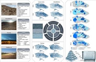
平衡人类活动与环境保护是保护区管理的一个关键挑战。空间分区是保护区管理的基石,在协调保护与发展方面起着至关重要的作用。本研究介绍了一种支持保护、修复、旅游和多边目标的综合土地利用管理战略。该方法将基于像素的优化与人工智能增强的基于对象的评估相结合。利用地理信息系统,我们编制并绘制了一套全面的生物、物理、基础设施和社会经济标准。采用加权线性组合(WLC)和有序加权平均(OWA)两种基于像元的方法对土地利用适宜性进行评价。利用多目标土地分配方法建立决策空间。随后使用一套人工智能模型进行基于目标的土地分配,包括增强回归树(BRT)、人工神经网络(ANN)、分类和回归树(CART)、极端梯度增强(XGBoost)和随机森林(RF)。结果表明,OWA方法在土地适宜性分析中优于WLC方法。当与基于对象的方法集成时,射频模型表现出最高的分配性能,其次是人工神经网络。值得注意的是,RF和MOLA模型的空间一致性最高。这一综合框架强调了将先进的人工智能驱动的基于对象的方法与传统的基于像素的技术相结合,以加强保护区的土地管理的潜力。研究结果为保护区的可持续空间规划提供了可操作的见解,这些保护区的土地利用目标可能是多样化和竞争性的。本文章由计算机程序翻译,如有差异,请以英文原文为准。
From pixels to objects: Integrated indicators for balancing sustainable management in protected areas
Balancing human activities with environmental protection is a critical challenge in managing Protected Areas (PAs). Spatial zoning serves as the cornerstone of PA management and plays a crucial role in harmonizing conservation with development. This study introduces an integrated land-use management strategy that supports conservation, rehabilitation, tourism, and multilateral objectives. The approach combines pixel-based optimization with AI-enhanced object-based evaluation. Using GIS, we compiled and mapped a comprehensive set of biological, physical, infrastructural, and socio-economic criteria. Two pixel-based methods, Weighted Linear Combination (WLC) and Ordered Weighted Averaging (OWA), were applied to assess land-use suitability. A decision space was established using the Multi-Objective Land Allocation (MOLA) method. Object-based land allocation was subsequently performed using a suite of artificial intelligence models, including Boosted Regression Trees (BRT), Artificial Neural Networks (ANN), Classification and Regression Trees (CART), eXtreme Gradient Boosting (XGBoost), and Random Forest (RF). The results showed that the OWA method outperformed WLC in land suitability analysis. When integrated into the object-based approach, the RF model demonstrated the highest allocation performance, followed by ANN. Notably, RF and MOLA models showed the highest spatial agreement. This integrative framework underscores the potential of combining advanced AI-driven object-based methods with conventional pixel-based techniques to strengthen land management in PAs. The findings offer actionable insights for sustainable spatial planning in protected areas where land-use goals may be diverse and competing.
求助全文
通过发布文献求助,成功后即可免费获取论文全文。
去求助
来源期刊

Ecological Informatics
环境科学-生态学
CiteScore
8.30
自引率
11.80%
发文量
346
审稿时长
46 days
期刊介绍:
The journal Ecological Informatics is devoted to the publication of high quality, peer-reviewed articles on all aspects of computational ecology, data science and biogeography. The scope of the journal takes into account the data-intensive nature of ecology, the growing capacity of information technology to access, harness and leverage complex data as well as the critical need for informing sustainable management in view of global environmental and climate change.
The nature of the journal is interdisciplinary at the crossover between ecology and informatics. It focuses on novel concepts and techniques for image- and genome-based monitoring and interpretation, sensor- and multimedia-based data acquisition, internet-based data archiving and sharing, data assimilation, modelling and prediction of ecological data.
 求助内容:
求助内容: 应助结果提醒方式:


