IF 2.7
2区 地球科学
Q2 GEOGRAPHY, PHYSICAL
Palaeogeography, Palaeoclimatology, Palaeoecology
Pub Date : 2025-08-19
DOI:10.1016/j.palaeo.2025.113169
引用次数: 0
摘要
然而,目前的研究主要集中在个别或少数湖泊的实地调查和岸线测年。本研究强调了整个青藏高原最高湖岸线的识别,并研究了海洋同位素第5阶段至全新世期间最大湖泊的范围和储水量变化,这有助于了解过去湖泊变化的特征,并有助于更准确地预测未来湖泊的变化。本研究通过谷歌Earth在TP上确定了最高湖岸线,并在2022年重建了自最大古湖以来在地质历史时期相对于现在湖泊的储水量变化。最后,我们发现在过去的一段时间里,有181个湖泊合并为115个湖泊。结果表明:最大湖期湖泊总面积为60 675 km2,是现代湖泊面积的近2倍,平均水位比现代湖泊高43 m,蓄水量变化2681 km3,是现代湖泊的3倍。变化较大的湖泊主要分布在青藏高原的南部和西部。组合湖群蓄水量变化量为1994 km3,占总变化量的74.38%。结合32个湖泊的年龄资料,发现湖泊最高水位的年龄主要出现在全新世、末次消冰期和海洋同位素阶段(MIS) 3。该研究有助于了解古湖泊变化的空间差异及其演化机制。本文章由计算机程序翻译,如有差异,请以英文原文为准。
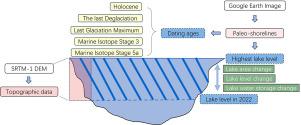
Lake shoreline identification and water storage change estimation of the largest lacustrine period from Marine Isotope Stage 5 to Holocene on the Tibetan Plateau
There are numerous lakes on the Tibetan Plateau (TP), which constitutes a significant part of the ”Water Tower of Asia”, and multiple high lake levels occurred during historical periods. However, current researches primarily focus on field investigations and dating of shorelines for individual or a few lakes. This study emphasized the identification of highest lake shorelines across the entire TP, along with a study of the extent and water storage variations of the largest lakes during Marine Isotope Stage 5 to Holocene, which is conducive to understand the characteristics of lake change in the past and facilitating more accurate prediction of future lake variation. In this study, we identified the highest lake shorelines on the TP by Google Earth, and reconstructed the water storage change since the largest paleo-lake during the geological historical period relative to current lake in 2022. Finally, we found that 181 lakes were merged into 115 lakes in the past period. The results showed that the total area of the lakes during the largest lacustrine period was 60 675 km2, which was nearly twice as large as the modern lakes, and the average water level was 43 m higher than that of the modern, with the water storage change of 2681 km3, which was 3 times of the modern. The lakes with large changes were mainly distributed in the southern and western parts of TP. The water storage change in the combined lake group was 1994 km3, accounting for 74.38% of the total change. Combined with the age data of 32 lakes, it showed that the ages of the highest water level of lakes mostly occurred in Holocene, the Last Deglaciation and the Marine Isotope Stage (MIS) 3. This study will be helpful to understand the spatial differences of paleo-lake changes and its evolution mechanism.
求助全文
通过发布文献求助,成功后即可免费获取论文全文。
去求助
来源期刊
CiteScore
5.90
自引率
10.00%
发文量
398
审稿时长
3.8 months
期刊介绍:
Palaeogeography, Palaeoclimatology, Palaeoecology is an international medium for the publication of high quality and multidisciplinary, original studies and comprehensive reviews in the field of palaeo-environmental geology. The journal aims at bringing together data with global implications from research in the many different disciplines involved in palaeo-environmental investigations.
By cutting across the boundaries of established sciences, it provides an interdisciplinary forum where issues of general interest can be discussed.
 求助内容:
求助内容: 应助结果提醒方式:


