南印度盾的岩石圈结构和演化:来自二维联合势场模拟、地震学和地质年代学数据的约束
IF 7.2
1区 地球科学
Q1 GEOSCIENCES, MULTIDISCIPLINARY
引用次数: 0
摘要
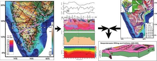
南印度地盾包括Bastar和Dharwar克拉通,南部麻粒岩地形,东高止移动带以及Pranahita Godavari和Cuddapah裂谷盆地。太古宙至元古代岩浆活动相关的多次合并和大火成岩省显著改变了该地区岩石圈,使构造和地质历史难以推断。这就需要通过地球物理资料来圈定岩石圈结构。在本研究中,利用地震和地震学数据约束下的二维联合势场模型来圈定南印度盾区岩石圈结构。约束势场模型显示:1)Cuddapah盆地、南部麻粒岩地和东高塞特活动带地区地壳密度较高,2)Dharwar和Bastar克拉通下方为中地壳低密度层,3)Pranahita Godavari和Cuddapah盆地下方Moho更深,4)Dharwar克拉通下方岩石圈相对较薄;(5)南部麻粒岩—达尔瓦尔克拉通边界区岩石圈相对较深。库达帕盆地和东高山带下高密度厚壳和浅层岩石圈的形成是由2200 Ma和1800 Ma左右的大火成岩省事件和1000 Ma左右的岩石圈交代作用造成的。在Pranahita Godavari地堑下的浅层岩石圈-软流圈边界反映了元古代的裂谷作用和冈瓦纳破裂期间的进一步恢复。南麻粒岩—达瓦尔克拉通边界下的岩石圈—软流圈边界是780 ~ 550 Ma俯冲事件引起的造山作用。推断达瓦尔克拉通地区独特的地壳结构、磁化和浅层岩石圈-软流圈边界是太古宙合并事件的结果,并叠加了2200 Ma和1800 Ma左右元古代大火成岩省事件。本文章由计算机程序翻译,如有差异,请以英文原文为准。
Lithosphere structure and evolution of the Southern Indian Shield: Constraints from 2-D joint potential field modelling, seismological and geochronological data
The Southern Indian Shield comprises the Bastar and Dharwar cratons, the Southern Granulite Terrain, the Eastern Ghat Mobile Belt, and the Pranahita Godavari and Cuddapah rift basins. Multiple amalgamations and large igneous provinces related to magmatism during the Archean to Proterozoic times significantly modified the lithosphere in this region, making it difficult to infer the structure and geological history. This necessitated the delineation of lithosphere structure through geophysical data. In this study, 2D joint potential field modelling constrained by seismic and seismological data is performed to delineate the lithospheric structure below the Southern Indian Shield region. The constrained potential field models reveal: i) Cuddapah Basin, Southern Granulite Terrain, and Eastern Ghats Mobile Belt regions are characterized by higher density crust, ii) a mid-crustal low-density layer below Dharwar and Bastar cratons, iii) deeper Moho below Pranahita Godavari and Cuddapah basins, iv) a comparatively thin lithosphere below Dharwar Craton; and v) relatively deeper lithosphere beneath Southern Granulite Terrain − Dharwar Craton boundary region. The high-density, thicker crust and shallow lithosphere beneath the Cuddapah Basin and the Eastern Ghat Mobile Belt have resulted from large igneous province events at ca 2200 Ma and 1800 Ma, followed by lithospheric metasomatism at ca 1000 Ma. The shallow Lithosphere-Asthenosphere Boundary beneath Pranahita Godavari graben reflects Proterozoic rifting and further reactivation during Gondwana breakup. The deeper Lithosphere-Asthenosphere Boundary beneath the Southern Granulite Terrain-Dharwar Craton boundary is attributed to orogenesis caused by subduction events between 780 Ma and 550 Ma. The distinct crustal structure, magnetisation, and shallow Lithosphere-Asthenosphere Boundary in the Dharwar Craton region are inferred to have resulted from amalgamation events during the Archean, overprinted by Proterozoic large igneous province events at ca 2200 Ma and 1800 Ma.
求助全文
通过发布文献求助,成功后即可免费获取论文全文。
去求助
来源期刊
Gondwana Research
地学-地球科学综合
CiteScore
12.90
自引率
6.60%
发文量
298
审稿时长
65 days
期刊介绍:
Gondwana Research (GR) is an International Journal aimed to promote high quality research publications on all topics related to solid Earth, particularly with reference to the origin and evolution of continents, continental assemblies and their resources. GR is an "all earth science" journal with no restrictions on geological time, terrane or theme and covers a wide spectrum of topics in geosciences such as geology, geomorphology, palaeontology, structure, petrology, geochemistry, stable isotopes, geochronology, economic geology, exploration geology, engineering geology, geophysics, and environmental geology among other themes, and provides an appropriate forum to integrate studies from different disciplines and different terrains. In addition to regular articles and thematic issues, the journal invites high profile state-of-the-art reviews on thrust area topics for its column, ''GR FOCUS''. Focus articles include short biographies and photographs of the authors. Short articles (within ten printed pages) for rapid publication reporting important discoveries or innovative models of global interest will be considered under the category ''GR LETTERS''.
 求助内容:
求助内容: 应助结果提醒方式:


