基于模糊贝叶斯网络的引水工程风险评价模型

IF 6.3 1区 地球科学 Q1 ENGINEERING, CIVIL
Yan Long , Luyao Xu , Xiaohui Lei , Zheng Zhang , Yilin Yang , Yingxia Li
{"title":"基于模糊贝叶斯网络的引水工程风险评价模型","authors":"Yan Long ,&nbsp;Luyao Xu ,&nbsp;Xiaohui Lei ,&nbsp;Zheng Zhang ,&nbsp;Yilin Yang ,&nbsp;Yingxia Li","doi":"10.1016/j.jhydrol.2025.134053","DOIUrl":null,"url":null,"abstract":"<div><div>The water transfer project spans a long distance, passing through various regions, including areas prone to heavy rainfall and floods, geological disaster zones, deep excavation and fill areas, and densely populated regions. It faces multiple risks including sudden pollution, flood overflow, and channel instability. Quickly and accurately identifying and assessing these risks is key to reducing potential losses. However, due to the limitations of available data, as well as its ambiguity, uncertainty, and complexity, existing assessment methods struggle to comprehensively and effectively identify the complex risks of water transfer projects. Therefore, this paper innovatively proposes a Bayesian network model based on fuzzy theory and hedging theory. It refines the risk level quantification through a fuzzy comprehensive evaluation membership function and calculates the likelihood function using hedging theory. The Bayesian network model is structured with risk levels as core nodes, disaster-causing factors as intermediate nodes, and risk accidents as terminal nodes. Finally, the defuzzification is carried out using the centroid method to accurately determine risk levels. The proposed method was applied to simulate typical risk characteristics in the South-to-North Water Diversion Project. Through three representative scenarios, the model’s applicability and risk identification capability under multi-source input conditions were systematically validated. Chi-square tests were performed to assess the statistical significance of each risk factor’s influence. The results demonstrate that the model exhibits high consistency and stability across different scenarios, providing reliable decision support for risk identification and the development of early warning strategies in water diversion projects.</div></div>","PeriodicalId":362,"journal":{"name":"Journal of Hydrology","volume":"662 ","pages":"Article 134053"},"PeriodicalIF":6.3000,"publicationDate":"2025-08-12","publicationTypes":"Journal Article","fieldsOfStudy":null,"isOpenAccess":false,"openAccessPdf":"","citationCount":"0","resultStr":"{\"title\":\"The risk assessment model for water diversion projects based on a fuzzy Bayesian network\",\"authors\":\"Yan Long ,&nbsp;Luyao Xu ,&nbsp;Xiaohui Lei ,&nbsp;Zheng Zhang ,&nbsp;Yilin Yang ,&nbsp;Yingxia Li\",\"doi\":\"10.1016/j.jhydrol.2025.134053\",\"DOIUrl\":null,\"url\":null,\"abstract\":\"<div><div>The water transfer project spans a long distance, passing through various regions, including areas prone to heavy rainfall and floods, geological disaster zones, deep excavation and fill areas, and densely populated regions. It faces multiple risks including sudden pollution, flood overflow, and channel instability. Quickly and accurately identifying and assessing these risks is key to reducing potential losses. However, due to the limitations of available data, as well as its ambiguity, uncertainty, and complexity, existing assessment methods struggle to comprehensively and effectively identify the complex risks of water transfer projects. Therefore, this paper innovatively proposes a Bayesian network model based on fuzzy theory and hedging theory. It refines the risk level quantification through a fuzzy comprehensive evaluation membership function and calculates the likelihood function using hedging theory. The Bayesian network model is structured with risk levels as core nodes, disaster-causing factors as intermediate nodes, and risk accidents as terminal nodes. Finally, the defuzzification is carried out using the centroid method to accurately determine risk levels. The proposed method was applied to simulate typical risk characteristics in the South-to-North Water Diversion Project. Through three representative scenarios, the model’s applicability and risk identification capability under multi-source input conditions were systematically validated. Chi-square tests were performed to assess the statistical significance of each risk factor’s influence. The results demonstrate that the model exhibits high consistency and stability across different scenarios, providing reliable decision support for risk identification and the development of early warning strategies in water diversion projects.</div></div>\",\"PeriodicalId\":362,\"journal\":{\"name\":\"Journal of Hydrology\",\"volume\":\"662 \",\"pages\":\"Article 134053\"},\"PeriodicalIF\":6.3000,\"publicationDate\":\"2025-08-12\",\"publicationTypes\":\"Journal Article\",\"fieldsOfStudy\":null,\"isOpenAccess\":false,\"openAccessPdf\":\"\",\"citationCount\":\"0\",\"resultStr\":null,\"platform\":\"Semanticscholar\",\"paperid\":null,\"PeriodicalName\":\"Journal of Hydrology\",\"FirstCategoryId\":\"89\",\"ListUrlMain\":\"https://www.sciencedirect.com/science/article/pii/S0022169425013915\",\"RegionNum\":1,\"RegionCategory\":\"地球科学\",\"ArticlePicture\":[],\"TitleCN\":null,\"AbstractTextCN\":null,\"PMCID\":null,\"EPubDate\":\"\",\"PubModel\":\"\",\"JCR\":\"Q1\",\"JCRName\":\"ENGINEERING, CIVIL\",\"Score\":null,\"Total\":0}","platform":"Semanticscholar","paperid":null,"PeriodicalName":"Journal of Hydrology","FirstCategoryId":"89","ListUrlMain":"https://www.sciencedirect.com/science/article/pii/S0022169425013915","RegionNum":1,"RegionCategory":"地球科学","ArticlePicture":[],"TitleCN":null,"AbstractTextCN":null,"PMCID":null,"EPubDate":"","PubModel":"","JCR":"Q1","JCRName":"ENGINEERING, CIVIL","Score":null,"Total":0}
引用次数: 0

摘要

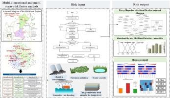
调水工程跨度较长,途经多个地区,包括强降雨和洪涝易发地区、地质灾害地区、深挖填区、人口密集地区等。它面临着突发性污染、洪水泛滥、航道失稳等多重风险。快速准确地识别和评估这些风险是减少潜在损失的关键。然而,由于现有数据的局限性,以及数据的模糊性、不确定性和复杂性,现有的评估方法难以全面有效地识别调水工程的复杂风险。因此,本文创新性地提出了一种基于模糊理论和套期保值理论的贝叶斯网络模型。通过模糊综合评价隶属度函数对风险等级量化进行细化,利用套期保值理论计算似然函数。贝叶斯网络模型以风险等级为核心节点,致灾因素为中间节点,风险事故为终端节点。最后,利用质心法进行去模糊化,准确确定风险等级。将该方法应用于南水北调工程典型风险特征的模拟。通过三个典型场景,系统验证了模型在多源输入条件下的适用性和风险识别能力。采用卡方检验评估各危险因素影响的统计学意义。结果表明,该模型在不同情景下具有较高的一致性和稳定性,为引水工程风险识别和预警策略的制定提供了可靠的决策支持。
本文章由计算机程序翻译,如有差异,请以英文原文为准。

The risk assessment model for water diversion projects based on a fuzzy Bayesian network

The risk assessment model for water diversion projects based on a fuzzy Bayesian network
The water transfer project spans a long distance, passing through various regions, including areas prone to heavy rainfall and floods, geological disaster zones, deep excavation and fill areas, and densely populated regions. It faces multiple risks including sudden pollution, flood overflow, and channel instability. Quickly and accurately identifying and assessing these risks is key to reducing potential losses. However, due to the limitations of available data, as well as its ambiguity, uncertainty, and complexity, existing assessment methods struggle to comprehensively and effectively identify the complex risks of water transfer projects. Therefore, this paper innovatively proposes a Bayesian network model based on fuzzy theory and hedging theory. It refines the risk level quantification through a fuzzy comprehensive evaluation membership function and calculates the likelihood function using hedging theory. The Bayesian network model is structured with risk levels as core nodes, disaster-causing factors as intermediate nodes, and risk accidents as terminal nodes. Finally, the defuzzification is carried out using the centroid method to accurately determine risk levels. The proposed method was applied to simulate typical risk characteristics in the South-to-North Water Diversion Project. Through three representative scenarios, the model’s applicability and risk identification capability under multi-source input conditions were systematically validated. Chi-square tests were performed to assess the statistical significance of each risk factor’s influence. The results demonstrate that the model exhibits high consistency and stability across different scenarios, providing reliable decision support for risk identification and the development of early warning strategies in water diversion projects.
求助全文
通过发布文献求助,成功后即可免费获取论文全文。 去求助
来源期刊
Journal of Hydrology
Journal of Hydrology 地学-地球科学综合
CiteScore
11.00
自引率
12.50%
发文量
1309
审稿时长
7.5 months
期刊介绍: The Journal of Hydrology publishes original research papers and comprehensive reviews in all the subfields of the hydrological sciences including water based management and policy issues that impact on economics and society. These comprise, but are not limited to the physical, chemical, biogeochemical, stochastic and systems aspects of surface and groundwater hydrology, hydrometeorology and hydrogeology. Relevant topics incorporating the insights and methodologies of disciplines such as climatology, water resource systems, hydraulics, agrohydrology, geomorphology, soil science, instrumentation and remote sensing, civil and environmental engineering are included. Social science perspectives on hydrological problems such as resource and ecological economics, environmental sociology, psychology and behavioural science, management and policy analysis are also invited. Multi-and interdisciplinary analyses of hydrological problems are within scope. The science published in the Journal of Hydrology is relevant to catchment scales rather than exclusively to a local scale or site.
×
引用
GB/T 7714-2015
复制
MLA
复制
APA
复制
导出至
BibTeX EndNote RefMan NoteFirst NoteExpress
×
提示
您的信息不完整,为了账户安全,请先补充。
现在去补充
×
提示
您因"违规操作"
具体请查看互助需知
我知道了
×
提示
确定
请完成安全验证×
copy
已复制链接
快去分享给好友吧!
我知道了
右上角分享
点击右上角分享
0
联系我们:info@booksci.cn Book学术提供免费学术资源搜索服务,方便国内外学者检索中英文文献。致力于提供最便捷和优质的服务体验。 Copyright © 2023 布克学术 All rights reserved.
京ICP备2023020795号-1
ghs 京公网安备 11010802042870号
Book学术文献互助
Book学术文献互助群
群 号:604180095
Book学术官方微信