Vitasha Adha Chaerul , I Gede Putu Fadjar Soerya Djaja , Prihandhanu Mukti Pratomo , Supriyadi , Elfitra Desifatma , Anggie Susilawati , Dini Andriani , Harry Mahardika , Eleonora Agustine , Wahyu Srigutomo
{"title":"利用瞬变电磁法在印度尼西亚西爪哇加鲁特的Santolo海滩识别沿海地区的海水入侵","authors":"Vitasha Adha Chaerul , I Gede Putu Fadjar Soerya Djaja , Prihandhanu Mukti Pratomo , Supriyadi , Elfitra Desifatma , Anggie Susilawati , Dini Andriani , Harry Mahardika , Eleonora Agustine , Wahyu Srigutomo","doi":"10.1016/j.geogeo.2025.100440","DOIUrl":null,"url":null,"abstract":"<div><div>Seawater intrusion contaminates freshwater in coastal areas, disrupting the environment and posing health risks due to high chloride content. Monitoring and mapping the seawater-freshwater interface is essential for evaluating and mitigating the environmental damage caused by this phenomenon. A widely used geophysical technique for mapping is the transient electromagnetic (TEM) method, which detects seawater intrusion by leveraging the significant resistivity differences between saline water, freshwater, and other geological layers.</div><div>This study utilized 21 TEM sounding points at Santolo Beach, Garut, West Java, Indonesia. The data were processed through an iterative inversion procedure using a smoothness constraint scheme. Interpretation of the transient magnetic field across all sounding points revealed a resistivity structure comprising three main layers: (1) a surface layer with high resistivity (>50 Ωm) extending to a depth of 15 m and thinning as it moves away from the coastline; (2) a middle layer with moderate resistivity (5–50 Ωm), ranging from 15 m to 40 m and thickening inland; and (3) a conductive layer, identified as seawater intrusion, with low resistivity (<5 Ωm), situated >40 m deep and deepening farther from the coastline. Additionally, water quality at several TEM sounding points was assessed using parameters such as total dissolved solids (TDS), electrical conductivity (EC), pH, and water temperature. The findings indicate that surface water in the area, obtained from wells and swamps, meets the required quality standards for potable water.</div></div>","PeriodicalId":100582,"journal":{"name":"Geosystems and Geoenvironment","volume":"5 1","pages":"Article 100440"},"PeriodicalIF":0.0000,"publicationDate":"2025-08-05","publicationTypes":"Journal Article","fieldsOfStudy":null,"isOpenAccess":false,"openAccessPdf":"","citationCount":"0","resultStr":"{\"title\":\"Identifying seawater intrusion in coastal areas using the transient electromagnetic method at Santolo Beach, Garut, West Java, Indonesia\",\"authors\":\"Vitasha Adha Chaerul , I Gede Putu Fadjar Soerya Djaja , Prihandhanu Mukti Pratomo , Supriyadi , Elfitra Desifatma , Anggie Susilawati , Dini Andriani , Harry Mahardika , Eleonora Agustine , Wahyu Srigutomo\",\"doi\":\"10.1016/j.geogeo.2025.100440\",\"DOIUrl\":null,\"url\":null,\"abstract\":\"<div><div>Seawater intrusion contaminates freshwater in coastal areas, disrupting the environment and posing health risks due to high chloride content. Monitoring and mapping the seawater-freshwater interface is essential for evaluating and mitigating the environmental damage caused by this phenomenon. A widely used geophysical technique for mapping is the transient electromagnetic (TEM) method, which detects seawater intrusion by leveraging the significant resistivity differences between saline water, freshwater, and other geological layers.</div><div>This study utilized 21 TEM sounding points at Santolo Beach, Garut, West Java, Indonesia. The data were processed through an iterative inversion procedure using a smoothness constraint scheme. Interpretation of the transient magnetic field across all sounding points revealed a resistivity structure comprising three main layers: (1) a surface layer with high resistivity (>50 Ωm) extending to a depth of 15 m and thinning as it moves away from the coastline; (2) a middle layer with moderate resistivity (5–50 Ωm), ranging from 15 m to 40 m and thickening inland; and (3) a conductive layer, identified as seawater intrusion, with low resistivity (<5 Ωm), situated >40 m deep and deepening farther from the coastline. Additionally, water quality at several TEM sounding points was assessed using parameters such as total dissolved solids (TDS), electrical conductivity (EC), pH, and water temperature. The findings indicate that surface water in the area, obtained from wells and swamps, meets the required quality standards for potable water.</div></div>\",\"PeriodicalId\":100582,\"journal\":{\"name\":\"Geosystems and Geoenvironment\",\"volume\":\"5 1\",\"pages\":\"Article 100440\"},\"PeriodicalIF\":0.0000,\"publicationDate\":\"2025-08-05\",\"publicationTypes\":\"Journal Article\",\"fieldsOfStudy\":null,\"isOpenAccess\":false,\"openAccessPdf\":\"\",\"citationCount\":\"0\",\"resultStr\":null,\"platform\":\"Semanticscholar\",\"paperid\":null,\"PeriodicalName\":\"Geosystems and Geoenvironment\",\"FirstCategoryId\":\"1085\",\"ListUrlMain\":\"https://www.sciencedirect.com/science/article/pii/S2772883825000883\",\"RegionNum\":0,\"RegionCategory\":null,\"ArticlePicture\":[],\"TitleCN\":null,\"AbstractTextCN\":null,\"PMCID\":null,\"EPubDate\":\"\",\"PubModel\":\"\",\"JCR\":\"\",\"JCRName\":\"\",\"Score\":null,\"Total\":0}","platform":"Semanticscholar","paperid":null,"PeriodicalName":"Geosystems and Geoenvironment","FirstCategoryId":"1085","ListUrlMain":"https://www.sciencedirect.com/science/article/pii/S2772883825000883","RegionNum":0,"RegionCategory":null,"ArticlePicture":[],"TitleCN":null,"AbstractTextCN":null,"PMCID":null,"EPubDate":"","PubModel":"","JCR":"","JCRName":"","Score":null,"Total":0}
Identifying seawater intrusion in coastal areas using the transient electromagnetic method at Santolo Beach, Garut, West Java, Indonesia
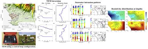
Seawater intrusion contaminates freshwater in coastal areas, disrupting the environment and posing health risks due to high chloride content. Monitoring and mapping the seawater-freshwater interface is essential for evaluating and mitigating the environmental damage caused by this phenomenon. A widely used geophysical technique for mapping is the transient electromagnetic (TEM) method, which detects seawater intrusion by leveraging the significant resistivity differences between saline water, freshwater, and other geological layers.
This study utilized 21 TEM sounding points at Santolo Beach, Garut, West Java, Indonesia. The data were processed through an iterative inversion procedure using a smoothness constraint scheme. Interpretation of the transient magnetic field across all sounding points revealed a resistivity structure comprising three main layers: (1) a surface layer with high resistivity (>50 Ωm) extending to a depth of 15 m and thinning as it moves away from the coastline; (2) a middle layer with moderate resistivity (5–50 Ωm), ranging from 15 m to 40 m and thickening inland; and (3) a conductive layer, identified as seawater intrusion, with low resistivity (<5 Ωm), situated >40 m deep and deepening farther from the coastline. Additionally, water quality at several TEM sounding points was assessed using parameters such as total dissolved solids (TDS), electrical conductivity (EC), pH, and water temperature. The findings indicate that surface water in the area, obtained from wells and swamps, meets the required quality standards for potable water.

 求助内容:
求助内容: 应助结果提醒方式:


