美国国家航空航天局模拟土壤湿度数据,作为饲料作物保险和灾害保护计划的指数:以俄克拉荷马州为例

IF 5.7 1区 农林科学 Q1 AGRONOMY
Ephraim D. Muyombo , B. Wade Brorsen , Erik S. Krueger , Tyson E. Ochsner , Andrew J. Van Leuven
{"title":"美国国家航空航天局模拟土壤湿度数据,作为饲料作物保险和灾害保护计划的指数:以俄克拉荷马州为例","authors":"Ephraim D. Muyombo ,&nbsp;B. Wade Brorsen ,&nbsp;Erik S. Krueger ,&nbsp;Tyson E. Ochsner ,&nbsp;Andrew J. Van Leuven","doi":"10.1016/j.agrformet.2025.110772","DOIUrl":null,"url":null,"abstract":"<div><div>Due to the lack of measured nationwide forage yield data, U.S. crop insurance and disaster programs for forage producers base payments on an index intended to correlate with forage yields. This study explores the feasibility of using National Aeronautics and Space Administration (NASA) soil moisture data to create an index for drought insurance and disaster programs. Hay yields in Oklahoma were used as the measure of forage yields due to the availability of data. We evaluated the relationship between those yields and soil moisture data from NASA’s Famine Early Warning Systems Network Land Data Assimilation System (FLDAS) and the Oklahoma Mesonet. We also consider forage yield relationships with the United States Drought Monitor (USDM), rainfall, in-situ soil moisture from the Oklahoma Mesonet, and NASA’s North American Land Data Assimilation System (NLDAS). The two main objectives are to (1) to determine the similarities and differences between FLDAS modeled soil moisture measurements and the in-situ soil moisture measurements obtained from the Oklahoma Mesonet, and (2) to quantify the accuracy of soil moisture measures as well as rainfall and the USDM in predicting county hay yields.</div><div>High correlations between FLDAS and Oklahoma Mesonet volumetric water content (VWC) were observed in central and western Oklahoma. Correlations were lower in eastern Oklahoma, urban areas, and irrigated regions.</div><div>Among the datasets considered, FLDAS VWC was consistently the best predictor of Oklahoma hay yields when using June and July drought measures. Linear regression models reveal that FLDAS Fraction of Available Water (FAW) (R² = 0.40), Mesonet FAW (R² = 0.40), 5-cm FLDAS VWC (R² = 0.43), 25-cm FLDAS VWC (R² = 0.43), NLDAS (R² = 0.39), USDM (R² = 0.28), and rainfall (R² = 0.30) were all significant predictors of hay yield anomalies. The ranking of the predictors remained the same when using quadratic or segmented regression models. FLDAS VWC is available in the continental U.S. at a 12 km resolution, making it a feasible alternative indicator for drought relief programs.</div></div>","PeriodicalId":50839,"journal":{"name":"Agricultural and Forest Meteorology","volume":"373 ","pages":"Article 110772"},"PeriodicalIF":5.7000,"publicationDate":"2025-08-12","publicationTypes":"Journal Article","fieldsOfStudy":null,"isOpenAccess":false,"openAccessPdf":"","citationCount":"0","resultStr":"{\"title\":\"NASA’s modeled soil moisture data as an index for forage crop insurance and disaster protection programs: The case of Oklahoma\",\"authors\":\"Ephraim D. Muyombo ,&nbsp;B. Wade Brorsen ,&nbsp;Erik S. Krueger ,&nbsp;Tyson E. Ochsner ,&nbsp;Andrew J. Van Leuven\",\"doi\":\"10.1016/j.agrformet.2025.110772\",\"DOIUrl\":null,\"url\":null,\"abstract\":\"<div><div>Due to the lack of measured nationwide forage yield data, U.S. crop insurance and disaster programs for forage producers base payments on an index intended to correlate with forage yields. This study explores the feasibility of using National Aeronautics and Space Administration (NASA) soil moisture data to create an index for drought insurance and disaster programs. Hay yields in Oklahoma were used as the measure of forage yields due to the availability of data. We evaluated the relationship between those yields and soil moisture data from NASA’s Famine Early Warning Systems Network Land Data Assimilation System (FLDAS) and the Oklahoma Mesonet. We also consider forage yield relationships with the United States Drought Monitor (USDM), rainfall, in-situ soil moisture from the Oklahoma Mesonet, and NASA’s North American Land Data Assimilation System (NLDAS). The two main objectives are to (1) to determine the similarities and differences between FLDAS modeled soil moisture measurements and the in-situ soil moisture measurements obtained from the Oklahoma Mesonet, and (2) to quantify the accuracy of soil moisture measures as well as rainfall and the USDM in predicting county hay yields.</div><div>High correlations between FLDAS and Oklahoma Mesonet volumetric water content (VWC) were observed in central and western Oklahoma. Correlations were lower in eastern Oklahoma, urban areas, and irrigated regions.</div><div>Among the datasets considered, FLDAS VWC was consistently the best predictor of Oklahoma hay yields when using June and July drought measures. Linear regression models reveal that FLDAS Fraction of Available Water (FAW) (R² = 0.40), Mesonet FAW (R² = 0.40), 5-cm FLDAS VWC (R² = 0.43), 25-cm FLDAS VWC (R² = 0.43), NLDAS (R² = 0.39), USDM (R² = 0.28), and rainfall (R² = 0.30) were all significant predictors of hay yield anomalies. The ranking of the predictors remained the same when using quadratic or segmented regression models. FLDAS VWC is available in the continental U.S. at a 12 km resolution, making it a feasible alternative indicator for drought relief programs.</div></div>\",\"PeriodicalId\":50839,\"journal\":{\"name\":\"Agricultural and Forest Meteorology\",\"volume\":\"373 \",\"pages\":\"Article 110772\"},\"PeriodicalIF\":5.7000,\"publicationDate\":\"2025-08-12\",\"publicationTypes\":\"Journal Article\",\"fieldsOfStudy\":null,\"isOpenAccess\":false,\"openAccessPdf\":\"\",\"citationCount\":\"0\",\"resultStr\":null,\"platform\":\"Semanticscholar\",\"paperid\":null,\"PeriodicalName\":\"Agricultural and Forest Meteorology\",\"FirstCategoryId\":\"97\",\"ListUrlMain\":\"https://www.sciencedirect.com/science/article/pii/S0168192325003910\",\"RegionNum\":1,\"RegionCategory\":\"农林科学\",\"ArticlePicture\":[],\"TitleCN\":null,\"AbstractTextCN\":null,\"PMCID\":null,\"EPubDate\":\"\",\"PubModel\":\"\",\"JCR\":\"Q1\",\"JCRName\":\"AGRONOMY\",\"Score\":null,\"Total\":0}","platform":"Semanticscholar","paperid":null,"PeriodicalName":"Agricultural and Forest Meteorology","FirstCategoryId":"97","ListUrlMain":"https://www.sciencedirect.com/science/article/pii/S0168192325003910","RegionNum":1,"RegionCategory":"农林科学","ArticlePicture":[],"TitleCN":null,"AbstractTextCN":null,"PMCID":null,"EPubDate":"","PubModel":"","JCR":"Q1","JCRName":"AGRONOMY","Score":null,"Total":0}
引用次数: 0

摘要

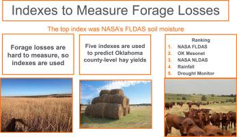
由于缺乏全国性的饲料产量数据,美国的作物保险和灾害计划为饲料生产商提供了一个与饲料产量相关的指数。本研究探讨了使用美国国家航空航天局(NASA)土壤湿度数据为干旱保险和灾害计划创建指数的可行性。由于数据的可用性,俄克拉荷马州的干草产量被用作饲料产量的衡量标准。我们评估了这些产量与来自美国宇航局饥荒预警系统网络土地数据同化系统(FLDAS)和俄克拉荷马州Mesonet的土壤湿度数据之间的关系。我们还考虑了牧草产量与美国干旱监测(USDM)、降雨量、俄克拉荷马州Mesonet的原位土壤湿度以及美国宇航局北美土地数据同化系统(NLDAS)之间的关系。两个主要目标是:(1)确定FLDAS模型土壤湿度测量值与俄克拉荷马州Mesonet获得的原位土壤湿度测量值之间的异同;(2)量化土壤湿度测量值、降雨量和USDM在预测县干草产量方面的准确性。在俄克拉何马州中部和西部,FLDAS与俄克拉何马Mesonet体积含水量(VWC)呈高度相关。俄克拉何马州东部、城市地区和灌溉区的相关性较低。在考虑的数据集中,当使用6月和7月的干旱措施时,FLDAS VWC一直是俄克拉荷马州干草产量的最佳预测器。线性回归模型显示,FLDAS有效水分分数(FAW) (R²= 0.40)、Mesonet FAW (R²= 0.40)、5 cm FLDAS VWC (R²= 0.43)、25 cm FLDAS VWC (R²= 0.43)、NLDAS (R²= 0.39)、USDM (R²= 0.28)和降雨量(R²= 0.30)均是干草产量异常的显著预测因子。当使用二次或分段回归模型时,预测因子的排名保持不变。FLDAS VWC在美国大陆以12公里的分辨率可用,使其成为干旱救济计划的可行替代指标。
本文章由计算机程序翻译,如有差异,请以英文原文为准。

NASA’s modeled soil moisture data as an index for forage crop insurance and disaster protection programs: The case of Oklahoma

NASA’s modeled soil moisture data as an index for forage crop insurance and disaster protection programs: The case of Oklahoma

NASA’s modeled soil moisture data as an index for forage crop insurance and disaster protection programs: The case of Oklahoma
Due to the lack of measured nationwide forage yield data, U.S. crop insurance and disaster programs for forage producers base payments on an index intended to correlate with forage yields. This study explores the feasibility of using National Aeronautics and Space Administration (NASA) soil moisture data to create an index for drought insurance and disaster programs. Hay yields in Oklahoma were used as the measure of forage yields due to the availability of data. We evaluated the relationship between those yields and soil moisture data from NASA’s Famine Early Warning Systems Network Land Data Assimilation System (FLDAS) and the Oklahoma Mesonet. We also consider forage yield relationships with the United States Drought Monitor (USDM), rainfall, in-situ soil moisture from the Oklahoma Mesonet, and NASA’s North American Land Data Assimilation System (NLDAS). The two main objectives are to (1) to determine the similarities and differences between FLDAS modeled soil moisture measurements and the in-situ soil moisture measurements obtained from the Oklahoma Mesonet, and (2) to quantify the accuracy of soil moisture measures as well as rainfall and the USDM in predicting county hay yields.
High correlations between FLDAS and Oklahoma Mesonet volumetric water content (VWC) were observed in central and western Oklahoma. Correlations were lower in eastern Oklahoma, urban areas, and irrigated regions.
Among the datasets considered, FLDAS VWC was consistently the best predictor of Oklahoma hay yields when using June and July drought measures. Linear regression models reveal that FLDAS Fraction of Available Water (FAW) (R² = 0.40), Mesonet FAW (R² = 0.40), 5-cm FLDAS VWC (R² = 0.43), 25-cm FLDAS VWC (R² = 0.43), NLDAS (R² = 0.39), USDM (R² = 0.28), and rainfall (R² = 0.30) were all significant predictors of hay yield anomalies. The ranking of the predictors remained the same when using quadratic or segmented regression models. FLDAS VWC is available in the continental U.S. at a 12 km resolution, making it a feasible alternative indicator for drought relief programs.
求助全文
通过发布文献求助,成功后即可免费获取论文全文。 去求助
来源期刊
CiteScore
10.30
自引率
9.70%
发文量
415
审稿时长
69 days
期刊介绍: Agricultural and Forest Meteorology is an international journal for the publication of original articles and reviews on the inter-relationship between meteorology, agriculture, forestry, and natural ecosystems. Emphasis is on basic and applied scientific research relevant to practical problems in the field of plant and soil sciences, ecology and biogeochemistry as affected by weather as well as climate variability and change. Theoretical models should be tested against experimental data. Articles must appeal to an international audience. Special issues devoted to single topics are also published. Typical topics include canopy micrometeorology (e.g. canopy radiation transfer, turbulence near the ground, evapotranspiration, energy balance, fluxes of trace gases), micrometeorological instrumentation (e.g., sensors for trace gases, flux measurement instruments, radiation measurement techniques), aerobiology (e.g. the dispersion of pollen, spores, insects and pesticides), biometeorology (e.g. the effect of weather and climate on plant distribution, crop yield, water-use efficiency, and plant phenology), forest-fire/weather interactions, and feedbacks from vegetation to weather and the climate system.
×
引用
GB/T 7714-2015
复制
MLA
复制
APA
复制
导出至
BibTeX EndNote RefMan NoteFirst NoteExpress
×
提示
您的信息不完整,为了账户安全,请先补充。
现在去补充
×
提示
您因"违规操作"
具体请查看互助需知
我知道了
×
提示
确定
请完成安全验证×
copy
已复制链接
快去分享给好友吧!
我知道了
右上角分享
点击右上角分享
0
联系我们:info@booksci.cn Book学术提供免费学术资源搜索服务,方便国内外学者检索中英文文献。致力于提供最便捷和优质的服务体验。 Copyright © 2023 布克学术 All rights reserved.
京ICP备2023020795号-1
ghs 京公网安备 11010802042870号
Book学术文献互助
Book学术文献互助群
群 号:604180095
Book学术官方微信