S. Pouyan, M. Zare, C. Samimi, M. R. Ekhtesasi, M. H. Mokhtari
{"title":"机器学习方法在沙漠地貌相区划中的应用","authors":"S. Pouyan, M. Zare, C. Samimi, M. R. Ekhtesasi, M. H. Mokhtari","doi":"10.1007/s13762-025-06621-z","DOIUrl":null,"url":null,"abstract":"<div><p>Identifying and managing geomorphological facies are fundamental aspects of geomorphological investigations. Remote sensing data is a widely used method for recognizing geomorphological facies. However, classifying desert facies using multispectral images is challenging due to the spectral similarities among them. This study focuses on the Yazd-Ardakan Plain in Central Iran, which features diverse arid land geomorphological facies, including clay plains, pavements, sand dunes, rocks, and vegetation. The classification of these facies was performed using random forest and support vector machine algorithms. Due to the spectral similarity of facies in this desert region, auxiliary data such as land surface temperature, normalized difference vegetation index, brightness temperature, and albedo were incorporated to enhance classification performance. Landsat 8 images and ground truth data were utilized, with 70% of the data allocated for training and 30% for testing. Results indicated that the overall accuracy of the support vector machine and random forest algorithms was 83.89% and 83.22%, respectively, with Kappa coefficients of 0.80 and 0.79. Both algorithms performed similarly in identifying geomorphological facies using spectral bands. However, by incorporating both spectral and auxiliary data, the Kappa coefficient and overall accuracy increased to 0.92 and 94.18% for the support vector machine algorithm and to 0.91 and 93.29% for the random forest algorithm. In conclusion, applying the random forest and support vector machine algorithms with auxiliary data led to more accurate geomorphological facies zoning, overcoming challenges posed by spectral similarities. This approach can be extended to other desert environments, providing a reliable methodology for improving landform classification and supporting natural resource management efforts.</p></div>","PeriodicalId":589,"journal":{"name":"International Journal of Environmental Science and Technology","volume":"22 13","pages":"12231 - 12244"},"PeriodicalIF":3.4000,"publicationDate":"2025-07-08","publicationTypes":"Journal Article","fieldsOfStudy":null,"isOpenAccess":false,"openAccessPdf":"","citationCount":"0","resultStr":"{\"title\":\"Application of machine learning approach in zoning of desert geomorphological facies\",\"authors\":\"S. Pouyan, M. Zare, C. Samimi, M. R. Ekhtesasi, M. H. Mokhtari\",\"doi\":\"10.1007/s13762-025-06621-z\",\"DOIUrl\":null,\"url\":null,\"abstract\":\"<div><p>Identifying and managing geomorphological facies are fundamental aspects of geomorphological investigations. Remote sensing data is a widely used method for recognizing geomorphological facies. However, classifying desert facies using multispectral images is challenging due to the spectral similarities among them. This study focuses on the Yazd-Ardakan Plain in Central Iran, which features diverse arid land geomorphological facies, including clay plains, pavements, sand dunes, rocks, and vegetation. The classification of these facies was performed using random forest and support vector machine algorithms. Due to the spectral similarity of facies in this desert region, auxiliary data such as land surface temperature, normalized difference vegetation index, brightness temperature, and albedo were incorporated to enhance classification performance. Landsat 8 images and ground truth data were utilized, with 70% of the data allocated for training and 30% for testing. Results indicated that the overall accuracy of the support vector machine and random forest algorithms was 83.89% and 83.22%, respectively, with Kappa coefficients of 0.80 and 0.79. Both algorithms performed similarly in identifying geomorphological facies using spectral bands. However, by incorporating both spectral and auxiliary data, the Kappa coefficient and overall accuracy increased to 0.92 and 94.18% for the support vector machine algorithm and to 0.91 and 93.29% for the random forest algorithm. In conclusion, applying the random forest and support vector machine algorithms with auxiliary data led to more accurate geomorphological facies zoning, overcoming challenges posed by spectral similarities. This approach can be extended to other desert environments, providing a reliable methodology for improving landform classification and supporting natural resource management efforts.</p></div>\",\"PeriodicalId\":589,\"journal\":{\"name\":\"International Journal of Environmental Science and Technology\",\"volume\":\"22 13\",\"pages\":\"12231 - 12244\"},\"PeriodicalIF\":3.4000,\"publicationDate\":\"2025-07-08\",\"publicationTypes\":\"Journal Article\",\"fieldsOfStudy\":null,\"isOpenAccess\":false,\"openAccessPdf\":\"\",\"citationCount\":\"0\",\"resultStr\":null,\"platform\":\"Semanticscholar\",\"paperid\":null,\"PeriodicalName\":\"International Journal of Environmental Science and Technology\",\"FirstCategoryId\":\"93\",\"ListUrlMain\":\"https://link.springer.com/article/10.1007/s13762-025-06621-z\",\"RegionNum\":4,\"RegionCategory\":\"环境科学与生态学\",\"ArticlePicture\":[],\"TitleCN\":null,\"AbstractTextCN\":null,\"PMCID\":null,\"EPubDate\":\"\",\"PubModel\":\"\",\"JCR\":\"Q2\",\"JCRName\":\"ENVIRONMENTAL SCIENCES\",\"Score\":null,\"Total\":0}","platform":"Semanticscholar","paperid":null,"PeriodicalName":"International Journal of Environmental Science and Technology","FirstCategoryId":"93","ListUrlMain":"https://link.springer.com/article/10.1007/s13762-025-06621-z","RegionNum":4,"RegionCategory":"环境科学与生态学","ArticlePicture":[],"TitleCN":null,"AbstractTextCN":null,"PMCID":null,"EPubDate":"","PubModel":"","JCR":"Q2","JCRName":"ENVIRONMENTAL SCIENCES","Score":null,"Total":0}
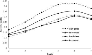
Application of machine learning approach in zoning of desert geomorphological facies
Identifying and managing geomorphological facies are fundamental aspects of geomorphological investigations. Remote sensing data is a widely used method for recognizing geomorphological facies. However, classifying desert facies using multispectral images is challenging due to the spectral similarities among them. This study focuses on the Yazd-Ardakan Plain in Central Iran, which features diverse arid land geomorphological facies, including clay plains, pavements, sand dunes, rocks, and vegetation. The classification of these facies was performed using random forest and support vector machine algorithms. Due to the spectral similarity of facies in this desert region, auxiliary data such as land surface temperature, normalized difference vegetation index, brightness temperature, and albedo were incorporated to enhance classification performance. Landsat 8 images and ground truth data were utilized, with 70% of the data allocated for training and 30% for testing. Results indicated that the overall accuracy of the support vector machine and random forest algorithms was 83.89% and 83.22%, respectively, with Kappa coefficients of 0.80 and 0.79. Both algorithms performed similarly in identifying geomorphological facies using spectral bands. However, by incorporating both spectral and auxiliary data, the Kappa coefficient and overall accuracy increased to 0.92 and 94.18% for the support vector machine algorithm and to 0.91 and 93.29% for the random forest algorithm. In conclusion, applying the random forest and support vector machine algorithms with auxiliary data led to more accurate geomorphological facies zoning, overcoming challenges posed by spectral similarities. This approach can be extended to other desert environments, providing a reliable methodology for improving landform classification and supporting natural resource management efforts.
期刊介绍:
International Journal of Environmental Science and Technology (IJEST) is an international scholarly refereed research journal which aims to promote the theory and practice of environmental science and technology, innovation, engineering and management.
A broad outline of the journal''s scope includes: peer reviewed original research articles, case and technical reports, reviews and analyses papers, short communications and notes to the editor, in interdisciplinary information on the practice and status of research in environmental science and technology, both natural and man made.
The main aspects of research areas include, but are not exclusive to; environmental chemistry and biology, environments pollution control and abatement technology, transport and fate of pollutants in the environment, concentrations and dispersion of wastes in air, water, and soil, point and non-point sources pollution, heavy metals and organic compounds in the environment, atmospheric pollutants and trace gases, solid and hazardous waste management; soil biodegradation and bioremediation of contaminated sites; environmental impact assessment, industrial ecology, ecological and human risk assessment; improved energy management and auditing efficiency and environmental standards and criteria.


 求助内容:
求助内容: 应助结果提醒方式:


