具有横向水文流动的全球湿度指数。
IF 48.5
1区 综合性期刊
Q1 MULTIDISCIPLINARY SCIENCES
引用次数: 0
摘要
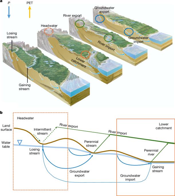
干旱指数被广泛用于指示陆地上的水分可用性。平衡气候供水(降水,P)和需求(潜在蒸散,PET),它通常表示为P/PET比率1或湿度指数。水也通过河流和地下水横向流动,从丘陵流到山谷,从高山流到平原,补贴接收的低地。在这里,我们证明了这种横向补贴减少了接收低地的干旱。我们首先用全球水文模型估算了30个″全球网格的地表水和地下水每月补贴(qrat)。然后用P/PET计算常规全球湿度指数(GHI),用(P + qat)/PET计算新的全球湿度指数(GHI)。后者被称为GHI_topo,反映陆地地形,在水文汇聚的低地较高。它还表现出延迟和潮湿的季节性(相对于P),因为延迟和扩散的laat到达接收低地。这种由气候和地形引起的时空特征,使GHI_topo成为下梯度社会和生态系统中当地可用水量的更现实的指标,使干旱地区和时间的生活成为可能。全球GHI topo≥1(供应满足或超过需求)的陆地面积比GHI≥1的陆地面积大33%,在干旱和季节干旱气候中要高得多。本文章由计算机程序翻译,如有差异,请以英文原文为准。
A global humidity index with lateral hydrologic flows
The aridity index is widely used to indicate water availability on land. Balancing climatic water supply (precipitation, P) against demand (potential evapotranspiration, PET), it is often expressed as the P/PET ratio1 or humidity index. Water also flows laterally by rivers and groundwater, from hills to valleys and from mountains to plains, subsidizing the receiving lowlands2. Here, we show that this lateral subsidy reduces aridity in the receiving lowlands. We first estimate monthly subsidies (Qlat) by surface and groundwater at 30″ global grids with a global hydrology model. We then calculate the conventional global humidity index (GHI) as P/PET and a new GHI including Qlat as (P + Qlat)/PET. Termed GHI_topo, the latter reflects land topography, higher in hydrologically convergent lowlands. It also exhibits a delayed and dampened seasonality (relative to P) owing to delayed and diffused Qlat arrival at the receiving lowlands. Such spatiotemporal features of Qlat, arising from both the climate and the terrain, make GHI_topo a more realistic indicator of local water availability in downgradient societies and ecosystems, enabling life in arid locations and times. Global land area with GHI_topo ≥ 1 (supply meets or exceeds demand) is 33% greater than GHI ≥ 1 and far higher in arid and season-arid climates. Estimating lateral subsidies by river and groundwater using a global hydrology model and incorporating them into the conventional global humidity index reduces aridity in the receiving lowlands and better explains ecosystem patterns.
求助全文
通过发布文献求助,成功后即可免费获取论文全文。
去求助
来源期刊
Nature
综合性期刊-综合性期刊
CiteScore
90.00
自引率
1.20%
发文量
3652
审稿时长
3 months
期刊介绍:
Nature is a prestigious international journal that publishes peer-reviewed research in various scientific and technological fields. The selection of articles is based on criteria such as originality, importance, interdisciplinary relevance, timeliness, accessibility, elegance, and surprising conclusions. In addition to showcasing significant scientific advances, Nature delivers rapid, authoritative, insightful news, and interpretation of current and upcoming trends impacting science, scientists, and the broader public. The journal serves a dual purpose: firstly, to promptly share noteworthy scientific advances and foster discussions among scientists, and secondly, to ensure the swift dissemination of scientific results globally, emphasizing their significance for knowledge, culture, and daily life.
 求助内容:
求助内容: 应助结果提醒方式:


