Sebastian Apers, Alexander R. Cobb, Gabriëlle J. M. De Lannoy, Michel Bechtold
{"title":"基于卫星的降雨表征热带泥炭地水文响应:以文莱为例研究","authors":"Sebastian Apers, Alexander R. Cobb, Gabriëlle J. M. De Lannoy, Michel Bechtold","doi":"10.1002/hyp.70209","DOIUrl":null,"url":null,"abstract":"<p>Peat hydraulic properties play a crucial role in regulating tropical peatland hydrology and are therefore critical parameters in peatland-specific hydrological models. Peat hydraulic and discharge parameters can be estimated by analysing time series of in situ water levels and precipitation, along with topographic data. However, in situ precipitation data are typically not available near water level measurements in densely vegetated and remote tropical peatlands. Gridded satellite precipitation products provide an alternative, but are coarse and highly uncertain. Here, we present a method for the hydrological parameterisation of water level dynamics using satellite-based precipitation, while accounting for representativeness errors in the precipitation data. First, we adapt the water level rise and recession analysis from Cobb and Harvey (<i>Water Resources Research</i>, 55 (11), 9351–9377; 2019) for use with Integrated Multi-satellitE Retrievals for Global Precipitation Measurement (IMERG) precipitation estimates. Applied to a tropical peatland in Brunei, the adapted rise and recession analysis reduces: (i) the average error in water level rise in response to rainfall and (ii) the average daily recession overestimation. In addition, we quantify the sensitivity of our adapted rise analysis to precipitation errors using an ensemble of precipitation time series with multiplicative errors. Second, the adapted master rise and recession curves are used to fit soil hydraulic and discharge function parameters within the peatland-specific module of the NASA Catchment Land Surface Model. Our analysis enables the retrieval of accurate hydrological parameters for our case study using IMERG data, and can be transferred to other peatlands and satellite-based precipitation products. It also highlights the importance in tropical peatland hydrology of cloud-scale forcing that is not resolved in existing satellite-based precipitation products.</p>","PeriodicalId":13189,"journal":{"name":"Hydrological Processes","volume":"39 8","pages":""},"PeriodicalIF":2.9000,"publicationDate":"2025-08-04","publicationTypes":"Journal Article","fieldsOfStudy":null,"isOpenAccess":false,"openAccessPdf":"https://onlinelibrary.wiley.com/doi/epdf/10.1002/hyp.70209","citationCount":"0","resultStr":"{\"title\":\"Characterising Tropical Peatland Hydrological Response With Satellite-Based Rainfall: A Case Study in Brunei\",\"authors\":\"Sebastian Apers, Alexander R. Cobb, Gabriëlle J. M. De Lannoy, Michel Bechtold\",\"doi\":\"10.1002/hyp.70209\",\"DOIUrl\":null,\"url\":null,\"abstract\":\"<p>Peat hydraulic properties play a crucial role in regulating tropical peatland hydrology and are therefore critical parameters in peatland-specific hydrological models. Peat hydraulic and discharge parameters can be estimated by analysing time series of in situ water levels and precipitation, along with topographic data. However, in situ precipitation data are typically not available near water level measurements in densely vegetated and remote tropical peatlands. Gridded satellite precipitation products provide an alternative, but are coarse and highly uncertain. Here, we present a method for the hydrological parameterisation of water level dynamics using satellite-based precipitation, while accounting for representativeness errors in the precipitation data. First, we adapt the water level rise and recession analysis from Cobb and Harvey (<i>Water Resources Research</i>, 55 (11), 9351–9377; 2019) for use with Integrated Multi-satellitE Retrievals for Global Precipitation Measurement (IMERG) precipitation estimates. Applied to a tropical peatland in Brunei, the adapted rise and recession analysis reduces: (i) the average error in water level rise in response to rainfall and (ii) the average daily recession overestimation. In addition, we quantify the sensitivity of our adapted rise analysis to precipitation errors using an ensemble of precipitation time series with multiplicative errors. Second, the adapted master rise and recession curves are used to fit soil hydraulic and discharge function parameters within the peatland-specific module of the NASA Catchment Land Surface Model. Our analysis enables the retrieval of accurate hydrological parameters for our case study using IMERG data, and can be transferred to other peatlands and satellite-based precipitation products. It also highlights the importance in tropical peatland hydrology of cloud-scale forcing that is not resolved in existing satellite-based precipitation products.</p>\",\"PeriodicalId\":13189,\"journal\":{\"name\":\"Hydrological Processes\",\"volume\":\"39 8\",\"pages\":\"\"},\"PeriodicalIF\":2.9000,\"publicationDate\":\"2025-08-04\",\"publicationTypes\":\"Journal Article\",\"fieldsOfStudy\":null,\"isOpenAccess\":false,\"openAccessPdf\":\"https://onlinelibrary.wiley.com/doi/epdf/10.1002/hyp.70209\",\"citationCount\":\"0\",\"resultStr\":null,\"platform\":\"Semanticscholar\",\"paperid\":null,\"PeriodicalName\":\"Hydrological Processes\",\"FirstCategoryId\":\"89\",\"ListUrlMain\":\"https://onlinelibrary.wiley.com/doi/10.1002/hyp.70209\",\"RegionNum\":3,\"RegionCategory\":\"地球科学\",\"ArticlePicture\":[],\"TitleCN\":null,\"AbstractTextCN\":null,\"PMCID\":null,\"EPubDate\":\"\",\"PubModel\":\"\",\"JCR\":\"Q1\",\"JCRName\":\"Environmental Science\",\"Score\":null,\"Total\":0}","platform":"Semanticscholar","paperid":null,"PeriodicalName":"Hydrological Processes","FirstCategoryId":"89","ListUrlMain":"https://onlinelibrary.wiley.com/doi/10.1002/hyp.70209","RegionNum":3,"RegionCategory":"地球科学","ArticlePicture":[],"TitleCN":null,"AbstractTextCN":null,"PMCID":null,"EPubDate":"","PubModel":"","JCR":"Q1","JCRName":"Environmental Science","Score":null,"Total":0}
Characterising Tropical Peatland Hydrological Response With Satellite-Based Rainfall: A Case Study in Brunei
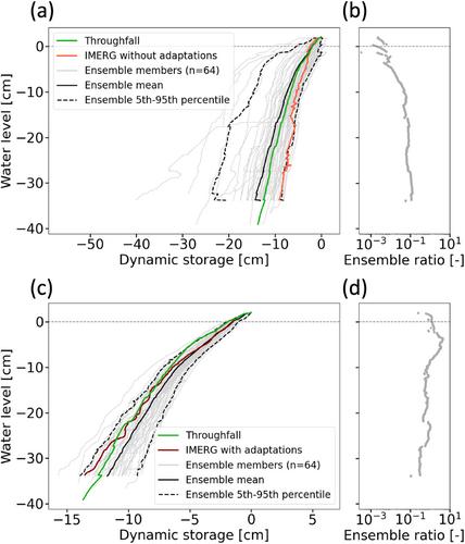
Peat hydraulic properties play a crucial role in regulating tropical peatland hydrology and are therefore critical parameters in peatland-specific hydrological models. Peat hydraulic and discharge parameters can be estimated by analysing time series of in situ water levels and precipitation, along with topographic data. However, in situ precipitation data are typically not available near water level measurements in densely vegetated and remote tropical peatlands. Gridded satellite precipitation products provide an alternative, but are coarse and highly uncertain. Here, we present a method for the hydrological parameterisation of water level dynamics using satellite-based precipitation, while accounting for representativeness errors in the precipitation data. First, we adapt the water level rise and recession analysis from Cobb and Harvey (Water Resources Research, 55 (11), 9351–9377; 2019) for use with Integrated Multi-satellitE Retrievals for Global Precipitation Measurement (IMERG) precipitation estimates. Applied to a tropical peatland in Brunei, the adapted rise and recession analysis reduces: (i) the average error in water level rise in response to rainfall and (ii) the average daily recession overestimation. In addition, we quantify the sensitivity of our adapted rise analysis to precipitation errors using an ensemble of precipitation time series with multiplicative errors. Second, the adapted master rise and recession curves are used to fit soil hydraulic and discharge function parameters within the peatland-specific module of the NASA Catchment Land Surface Model. Our analysis enables the retrieval of accurate hydrological parameters for our case study using IMERG data, and can be transferred to other peatlands and satellite-based precipitation products. It also highlights the importance in tropical peatland hydrology of cloud-scale forcing that is not resolved in existing satellite-based precipitation products.
期刊介绍:
Hydrological Processes is an international journal that publishes original scientific papers advancing understanding of the mechanisms underlying the movement and storage of water in the environment, and the interaction of water with geological, biogeochemical, atmospheric and ecological systems. Not all papers related to water resources are appropriate for submission to this journal; rather we seek papers that clearly articulate the role(s) of hydrological processes.

 求助内容:
求助内容: 应助结果提醒方式:


