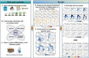
基于灾害过程的东北水稻冻害实时风险评估

IF 5.5 1区 农林科学 Q1 AGRONOMY
Bilige Sudu , Sicheng Wei , Suri Guga , Cha Ersi , Ying Guo , Feng Zhi , Teri Gele , Zhenhua Dong , Mula Na , Zhijun Tong , Xingpeng Liu , Jiquan Zhang
{"title":"基于灾害过程的东北水稻冻害实时风险评估","authors":"Bilige Sudu ,&nbsp;Sicheng Wei ,&nbsp;Suri Guga ,&nbsp;Cha Ersi ,&nbsp;Ying Guo ,&nbsp;Feng Zhi ,&nbsp;Teri Gele ,&nbsp;Zhenhua Dong ,&nbsp;Mula Na ,&nbsp;Zhijun Tong ,&nbsp;Xingpeng Liu ,&nbsp;Jiquan Zhang","doi":"10.1016/j.eja.2025.127802","DOIUrl":null,"url":null,"abstract":"<div><div>Although global warming has reduced the frequency of large-scale severe chilling injury in Northeast China, such risks have not been eliminated. Regional and periodic chilling injury events still occur frequently and are even showing signs of increasing intensity. To enhance the capability of chilling injury identification and early warning, this study constructed a cumulative intensity index based on the daily accumulation process. Meteorological data from Northeast China (1991–2020) were used to analyze the spatiotemporal differentiation characteristics of rice chilling injuries. It also integrates sun-induced chlorophyll fluorescence (SIF) to assess crop adaptability. Furthermore, random forest (RF), the DSSAT crop model, and the analytic hierarchy process (AHP) were employed to incorporate a natural disaster risk index and develop a real-time risk assessment model for the rice chilling injury. The model was validated using three chilling events from 2002, 2017, and 2020. Results showed that during the tillering and booting stages, SIF is significantly negatively correlated with the cumulative intensity index, indicating that SIF had strong potential as an early remote sensing indicator for chilling injury. Through retrospective real-time risk assessments of three representative historical chilling injury events, we found that high-latitude rice growing areas are more vulnerable to chilling stress. For instance, during the 2002 chilling event, the proportion of moderate-risk areas rose to 49 %, while high-risk areas reached 17 %. This spatial distribution pattern reflects historical disaster trends and supports farmers and agricultural agencies in assessing chilling injury risk, enabling timely preventive measures and contributing to national food security.</div></div>","PeriodicalId":51045,"journal":{"name":"European Journal of Agronomy","volume":"171 ","pages":"Article 127802"},"PeriodicalIF":5.5000,"publicationDate":"2025-08-05","publicationTypes":"Journal Article","fieldsOfStudy":null,"isOpenAccess":false,"openAccessPdf":"","citationCount":"0","resultStr":"{\"title\":\"Real-time risk assessment of rice chilling injury based on disaster processes in Northeast China\",\"authors\":\"Bilige Sudu ,&nbsp;Sicheng Wei ,&nbsp;Suri Guga ,&nbsp;Cha Ersi ,&nbsp;Ying Guo ,&nbsp;Feng Zhi ,&nbsp;Teri Gele ,&nbsp;Zhenhua Dong ,&nbsp;Mula Na ,&nbsp;Zhijun Tong ,&nbsp;Xingpeng Liu ,&nbsp;Jiquan Zhang\",\"doi\":\"10.1016/j.eja.2025.127802\",\"DOIUrl\":null,\"url\":null,\"abstract\":\"<div><div>Although global warming has reduced the frequency of large-scale severe chilling injury in Northeast China, such risks have not been eliminated. Regional and periodic chilling injury events still occur frequently and are even showing signs of increasing intensity. To enhance the capability of chilling injury identification and early warning, this study constructed a cumulative intensity index based on the daily accumulation process. Meteorological data from Northeast China (1991–2020) were used to analyze the spatiotemporal differentiation characteristics of rice chilling injuries. It also integrates sun-induced chlorophyll fluorescence (SIF) to assess crop adaptability. Furthermore, random forest (RF), the DSSAT crop model, and the analytic hierarchy process (AHP) were employed to incorporate a natural disaster risk index and develop a real-time risk assessment model for the rice chilling injury. The model was validated using three chilling events from 2002, 2017, and 2020. Results showed that during the tillering and booting stages, SIF is significantly negatively correlated with the cumulative intensity index, indicating that SIF had strong potential as an early remote sensing indicator for chilling injury. Through retrospective real-time risk assessments of three representative historical chilling injury events, we found that high-latitude rice growing areas are more vulnerable to chilling stress. For instance, during the 2002 chilling event, the proportion of moderate-risk areas rose to 49 %, while high-risk areas reached 17 %. This spatial distribution pattern reflects historical disaster trends and supports farmers and agricultural agencies in assessing chilling injury risk, enabling timely preventive measures and contributing to national food security.</div></div>\",\"PeriodicalId\":51045,\"journal\":{\"name\":\"European Journal of Agronomy\",\"volume\":\"171 \",\"pages\":\"Article 127802\"},\"PeriodicalIF\":5.5000,\"publicationDate\":\"2025-08-05\",\"publicationTypes\":\"Journal Article\",\"fieldsOfStudy\":null,\"isOpenAccess\":false,\"openAccessPdf\":\"\",\"citationCount\":\"0\",\"resultStr\":null,\"platform\":\"Semanticscholar\",\"paperid\":null,\"PeriodicalName\":\"European Journal of Agronomy\",\"FirstCategoryId\":\"97\",\"ListUrlMain\":\"https://www.sciencedirect.com/science/article/pii/S1161030125002989\",\"RegionNum\":1,\"RegionCategory\":\"农林科学\",\"ArticlePicture\":[],\"TitleCN\":null,\"AbstractTextCN\":null,\"PMCID\":null,\"EPubDate\":\"\",\"PubModel\":\"\",\"JCR\":\"Q1\",\"JCRName\":\"AGRONOMY\",\"Score\":null,\"Total\":0}","platform":"Semanticscholar","paperid":null,"PeriodicalName":"European Journal of Agronomy","FirstCategoryId":"97","ListUrlMain":"https://www.sciencedirect.com/science/article/pii/S1161030125002989","RegionNum":1,"RegionCategory":"农林科学","ArticlePicture":[],"TitleCN":null,"AbstractTextCN":null,"PMCID":null,"EPubDate":"","PubModel":"","JCR":"Q1","JCRName":"AGRONOMY","Score":null,"Total":0}
引用次数: 0

摘要

尽管全球变暖降低了东北地区大规模严重冻害发生的频率,但这种风险并未完全消除。区域性和周期性的寒害事件仍然频繁发生,甚至显示出强度增加的迹象。为了提高冷害识别和预警能力,本研究构建了基于日积累过程的累积强度指数。利用东北地区1991-2020年气象资料,分析了水稻冷害的时空分异特征。它还集成了太阳诱导的叶绿素荧光(SIF)来评估作物的适应性。在此基础上,采用随机森林(RF)、DSSAT作物模型和层次分析法(AHP)结合自然灾害风险指数,建立了水稻冷害实时风险评估模型。该模型使用2002年、2017年和2020年的三次令人不寒而栗的事件进行了验证。结果表明,分蘖期和孕穗期SIF与累积强度指数呈显著负相关,表明SIF具有很强的寒害早期遥感指标潜力。通过对三个具有代表性的历史冷害事件的回顾性实时风险评估,我们发现高纬度水稻产区更容易受到冷害胁迫。例如,在2002年寒潮期间,中等风险地区的比例上升到49% %,而高风险地区的比例达到17% %。这一空间分布格局反映了历史灾害趋势,有助于农民和农业机构评估冻害风险,及时采取预防措施,促进国家粮食安全。
本文章由计算机程序翻译,如有差异,请以英文原文为准。

Real-time risk assessment of rice chilling injury based on disaster processes in Northeast China

Real-time risk assessment of rice chilling injury based on disaster processes in Northeast China
Although global warming has reduced the frequency of large-scale severe chilling injury in Northeast China, such risks have not been eliminated. Regional and periodic chilling injury events still occur frequently and are even showing signs of increasing intensity. To enhance the capability of chilling injury identification and early warning, this study constructed a cumulative intensity index based on the daily accumulation process. Meteorological data from Northeast China (1991–2020) were used to analyze the spatiotemporal differentiation characteristics of rice chilling injuries. It also integrates sun-induced chlorophyll fluorescence (SIF) to assess crop adaptability. Furthermore, random forest (RF), the DSSAT crop model, and the analytic hierarchy process (AHP) were employed to incorporate a natural disaster risk index and develop a real-time risk assessment model for the rice chilling injury. The model was validated using three chilling events from 2002, 2017, and 2020. Results showed that during the tillering and booting stages, SIF is significantly negatively correlated with the cumulative intensity index, indicating that SIF had strong potential as an early remote sensing indicator for chilling injury. Through retrospective real-time risk assessments of three representative historical chilling injury events, we found that high-latitude rice growing areas are more vulnerable to chilling stress. For instance, during the 2002 chilling event, the proportion of moderate-risk areas rose to 49 %, while high-risk areas reached 17 %. This spatial distribution pattern reflects historical disaster trends and supports farmers and agricultural agencies in assessing chilling injury risk, enabling timely preventive measures and contributing to national food security.
求助全文
通过发布文献求助,成功后即可免费获取论文全文。 去求助
来源期刊
European Journal of Agronomy
European Journal of Agronomy 农林科学-农艺学
CiteScore
8.30
自引率
7.70%
发文量
187
审稿时长
4.5 months
期刊介绍: The European Journal of Agronomy, the official journal of the European Society for Agronomy, publishes original research papers reporting experimental and theoretical contributions to field-based agronomy and crop science. The journal will consider research at the field level for agricultural, horticultural and tree crops, that uses comprehensive and explanatory approaches. The EJA covers the following topics: crop physiology crop production and management including irrigation, fertilization and soil management agroclimatology and modelling plant-soil relationships crop quality and post-harvest physiology farming and cropping systems agroecosystems and the environment crop-weed interactions and management organic farming horticultural crops papers from the European Society for Agronomy bi-annual meetings In determining the suitability of submitted articles for publication, particular scrutiny is placed on the degree of novelty and significance of the research and the extent to which it adds to existing knowledge in agronomy.
×
引用
GB/T 7714-2015
复制
MLA
复制
APA
复制
导出至
BibTeX EndNote RefMan NoteFirst NoteExpress
×
提示
您的信息不完整,为了账户安全,请先补充。
现在去补充
×
提示
您因"违规操作"
具体请查看互助需知
我知道了
×
提示
确定
请完成安全验证×
copy
已复制链接
快去分享给好友吧!
我知道了
右上角分享
点击右上角分享
0
联系我们:info@booksci.cn Book学术提供免费学术资源搜索服务,方便国内外学者检索中英文文献。致力于提供最便捷和优质的服务体验。 Copyright © 2023 布克学术 All rights reserved.
京ICP备2023020795号-1
ghs 京公网安备 11010802042870号
Book学术文献互助
Book学术文献互助群
群 号:604180095
Book学术官方微信