复合指纹图谱揭示的风暴水文变化时空源贡献
IF 5
2区 地球科学
Q1 WATER RESOURCES
引用次数: 0
摘要
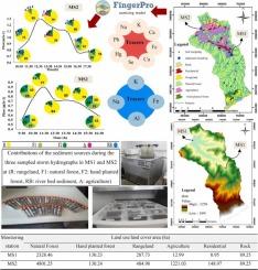
Kasilian流域位于马赞达兰省东部,面积为67.22 km2。研究重点研究降雨过程中沉积物来源的时空变化。为此,从各种土地用途中收集源样本,包括牧场、天然林、人工种植林和农业,以及河床。在MS1(流域中部)和MS2(流域出水口)两个监测站的3次降雨期间,每隔60分钟对悬浮泥沙进行采样。测定源、沉积物样品中59种地球化学元素的浓度,利用R软件中的FingerPro软件包进行统计检验,选择复合指纹图谱。新的水文见解RegionThe研究发现,牧场的贡献,自然森林,手工制作的森林,和河床MS1 46 %,24 %,19 %,和11 %,分别在一份,贡献72 %,7 % 4 %,14 %,3 %农业土地。此外,事件内变化表明,在MS1,在水文曲线高峰,牧场贡献最大,而在上升和下降阶段,牧场和天然林都占主导地位。在MS2,牧场在所有水文相中贡献最大。这些发现为管理者制定管理方案提供了有价值的信息。本文章由计算机程序翻译,如有差异,请以英文原文为准。
Variable spatio-temporal source contributions during storm hydrographs revealed by composite fingerprinting
Study Region
The Kasilian watershed with an area of 67.22 km2 is located in the eastern part of Mazandaran province.
Study Focus
This study investigated the spatio-temporal variations in sediment sources during rainfall events. For this purpose, source samples were collected from various land uses, including rangeland, natural forest, hand-planted forest, and agriculture, as well as from the river bed. Suspended sediment sampling was conducted at 60-minute intervals during three rainfall events at two monitoring stations: MS1 (mid-watershed) and MS2 (watershed outlet). The concentration of 59 geochemical elements in source and sediment samples was measured, and composite fingerprints were selected using statistical tests in the FingerPro package in R software.
New Hydrological Insights for the Region
The study found that the contributions of rangelands, natural forests, hand-planted forests, and the river bed at MS1 were 46 %, 24 %, 19 %, and 11 %, respectively, while at MS2, the contributions were 72 %, 7 %, 4 %, 14 %, and 3 % for agricultural lands. Additionally, intra-event variations showed that at MS1, rangelands contributed the most at the hydrograph peak, whereas during the rising and falling limbs, both rangelands and natural forests were dominant. At MS2, rangelands had the highest contribution throughout all hydrograph phases. These findings provide valuable information for managers in developing management programs.
求助全文
通过发布文献求助,成功后即可免费获取论文全文。
去求助
来源期刊

Journal of Hydrology-Regional Studies
Earth and Planetary Sciences-Earth and Planetary Sciences (miscellaneous)
CiteScore
6.70
自引率
8.50%
发文量
284
审稿时长
60 days
期刊介绍:
Journal of Hydrology: Regional Studies publishes original research papers enhancing the science of hydrology and aiming at region-specific problems, past and future conditions, analysis, review and solutions. The journal particularly welcomes research papers that deliver new insights into region-specific hydrological processes and responses to changing conditions, as well as contributions that incorporate interdisciplinarity and translational science.
 求助内容:
求助内容: 应助结果提醒方式:


