Seyed Vahid Razavi-Termeh , Abolghasem Sadeghi-Niaraki , Farman Ali , Saied Pirasteh , Soo-Mi Choi
{"title":"基于元启发式算法的深度表学习优化增强地表沉降敏感性制图","authors":"Seyed Vahid Razavi-Termeh , Abolghasem Sadeghi-Niaraki , Farman Ali , Saied Pirasteh , Soo-Mi Choi","doi":"10.1016/j.gr.2025.07.002","DOIUrl":null,"url":null,"abstract":"<div><div>Land subsidence, a gradual sinking of the Earth’s surface, poses significant threats to urban and rural landscapes, leading to severe environmental, social, and economic consequences. Land subsidence monitoring and susceptibility mapping are important for urban planning and geohazard assessment. Previous research on Land Subsidence Susceptibility Modeling (LLSM) often relied on field survey data and traditional deep learning methods and lacked optimal hyperparameter tuning. To address these gaps, this study employed a Deep Tabular Learning algorithm, specifically TabNet (Attention interpretable tabular learning), optimized using three metaheuristic algorithms: Particle Swarm Optimization (PSO), Cuckoo Search (CS), and Whale Optimization Algorithm (WOA) and land subsidence detection in Kurdistan Province, Iran, from 2015 to 2022, utilizing Interferometric Synthetic Aperture Radar (InSAR) time analysis. The spatial database for modeling integrated land subsidence occurrence areas was derived from InSAR data with 15 critical criteria, including topographic, climatic, geological, and land-cover information. The modeling results and susceptibility maps revealed that the TabNet-CS model exhibited the highest accuracy in predicting land subsidence susceptibility, with a Root Mean Square Error (RMSE) of 0.223, Mean Absolute Error (MAE) of 0.125, and Area Under the Curve (AUC) of 0.956. The TabNet-PSO model demonstrated good performance, with RMSE = 0.241, MAE = 0.143, and AUC = 0.941. The TabNet-WOA model also showed promising results with RMSE = 0.255, MAE = 0.154, and AUC = 0.931. Finally, the standalone TabNet model yielded comparatively lower accuracy with RMSE = 0.297, MAE = 0.199, and AUC = 0.92. Integrating metaheuristic algorithms (CS, PSO, and WOA) improved the accuracy of the TabNet model by 3.6, 2.1, and 1.2 %, respectively.</div></div>","PeriodicalId":12761,"journal":{"name":"Gondwana Research","volume":"148 ","pages":"Pages 53-76"},"PeriodicalIF":7.2000,"publicationDate":"2025-07-27","publicationTypes":"Journal Article","fieldsOfStudy":null,"isOpenAccess":false,"openAccessPdf":"","citationCount":"0","resultStr":"{\"title\":\"Enhancing land subsidence susceptibility mapping using deep tabular learning optimization with metaheuristic algorithms\",\"authors\":\"Seyed Vahid Razavi-Termeh , Abolghasem Sadeghi-Niaraki , Farman Ali , Saied Pirasteh , Soo-Mi Choi\",\"doi\":\"10.1016/j.gr.2025.07.002\",\"DOIUrl\":null,\"url\":null,\"abstract\":\"<div><div>Land subsidence, a gradual sinking of the Earth’s surface, poses significant threats to urban and rural landscapes, leading to severe environmental, social, and economic consequences. Land subsidence monitoring and susceptibility mapping are important for urban planning and geohazard assessment. Previous research on Land Subsidence Susceptibility Modeling (LLSM) often relied on field survey data and traditional deep learning methods and lacked optimal hyperparameter tuning. To address these gaps, this study employed a Deep Tabular Learning algorithm, specifically TabNet (Attention interpretable tabular learning), optimized using three metaheuristic algorithms: Particle Swarm Optimization (PSO), Cuckoo Search (CS), and Whale Optimization Algorithm (WOA) and land subsidence detection in Kurdistan Province, Iran, from 2015 to 2022, utilizing Interferometric Synthetic Aperture Radar (InSAR) time analysis. The spatial database for modeling integrated land subsidence occurrence areas was derived from InSAR data with 15 critical criteria, including topographic, climatic, geological, and land-cover information. The modeling results and susceptibility maps revealed that the TabNet-CS model exhibited the highest accuracy in predicting land subsidence susceptibility, with a Root Mean Square Error (RMSE) of 0.223, Mean Absolute Error (MAE) of 0.125, and Area Under the Curve (AUC) of 0.956. The TabNet-PSO model demonstrated good performance, with RMSE = 0.241, MAE = 0.143, and AUC = 0.941. The TabNet-WOA model also showed promising results with RMSE = 0.255, MAE = 0.154, and AUC = 0.931. Finally, the standalone TabNet model yielded comparatively lower accuracy with RMSE = 0.297, MAE = 0.199, and AUC = 0.92. Integrating metaheuristic algorithms (CS, PSO, and WOA) improved the accuracy of the TabNet model by 3.6, 2.1, and 1.2 %, respectively.</div></div>\",\"PeriodicalId\":12761,\"journal\":{\"name\":\"Gondwana Research\",\"volume\":\"148 \",\"pages\":\"Pages 53-76\"},\"PeriodicalIF\":7.2000,\"publicationDate\":\"2025-07-27\",\"publicationTypes\":\"Journal Article\",\"fieldsOfStudy\":null,\"isOpenAccess\":false,\"openAccessPdf\":\"\",\"citationCount\":\"0\",\"resultStr\":null,\"platform\":\"Semanticscholar\",\"paperid\":null,\"PeriodicalName\":\"Gondwana Research\",\"FirstCategoryId\":\"89\",\"ListUrlMain\":\"https://www.sciencedirect.com/science/article/pii/S1342937X25002229\",\"RegionNum\":1,\"RegionCategory\":\"地球科学\",\"ArticlePicture\":[],\"TitleCN\":null,\"AbstractTextCN\":null,\"PMCID\":null,\"EPubDate\":\"\",\"PubModel\":\"\",\"JCR\":\"Q1\",\"JCRName\":\"GEOSCIENCES, MULTIDISCIPLINARY\",\"Score\":null,\"Total\":0}","platform":"Semanticscholar","paperid":null,"PeriodicalName":"Gondwana Research","FirstCategoryId":"89","ListUrlMain":"https://www.sciencedirect.com/science/article/pii/S1342937X25002229","RegionNum":1,"RegionCategory":"地球科学","ArticlePicture":[],"TitleCN":null,"AbstractTextCN":null,"PMCID":null,"EPubDate":"","PubModel":"","JCR":"Q1","JCRName":"GEOSCIENCES, MULTIDISCIPLINARY","Score":null,"Total":0}
引用次数: 0
摘要
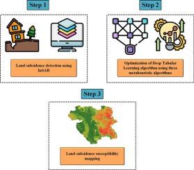
地面沉降,即地球表面的逐渐下沉,对城市和农村景观构成了重大威胁,导致了严重的环境、社会和经济后果。地面沉降监测和易感度制图对城市规划和地质灾害评价具有重要意义。以往的地面沉降敏感性建模(LLSM)研究往往依赖于实地调查数据和传统的深度学习方法,缺乏最优的超参数整定。为了解决这些差距,本研究采用了深度表学习算法,特别是TabNet(注意可解释表学习),并使用三种元启发式算法:粒子群优化(PSO)、布谷鸟搜索(CS)和鲸鱼优化算法(WOA)进行优化,并利用干涉合成孔径雷达(InSAR)时间分析,于2015年至2022年在伊朗库尔德斯坦省进行了地面沉降检测。综合地面沉降发生区域建模的空间数据库是基于InSAR数据的15个关键标准,包括地形、气候、地质和土地覆盖信息。结果表明,TabNet-CS模型对地表沉降敏感性的预测精度最高,均方根误差(RMSE)为0.223,平均绝对误差(MAE)为0.125,曲线下面积(AUC)为0.956。TabNet-PSO模型表现出较好的性能,RMSE = 0.241, MAE = 0.143, AUC = 0.941。TabNet-WOA模型的RMSE = 0.255, MAE = 0.154, AUC = 0.931。最后,独立TabNet模型的准确率相对较低,RMSE = 0.297, MAE = 0.199, AUC = 0.92。整合元启发式算法(CS, PSO和WOA)分别将TabNet模型的准确性提高了3.6%,2.1%和1.2%。
Enhancing land subsidence susceptibility mapping using deep tabular learning optimization with metaheuristic algorithms
Land subsidence, a gradual sinking of the Earth’s surface, poses significant threats to urban and rural landscapes, leading to severe environmental, social, and economic consequences. Land subsidence monitoring and susceptibility mapping are important for urban planning and geohazard assessment. Previous research on Land Subsidence Susceptibility Modeling (LLSM) often relied on field survey data and traditional deep learning methods and lacked optimal hyperparameter tuning. To address these gaps, this study employed a Deep Tabular Learning algorithm, specifically TabNet (Attention interpretable tabular learning), optimized using three metaheuristic algorithms: Particle Swarm Optimization (PSO), Cuckoo Search (CS), and Whale Optimization Algorithm (WOA) and land subsidence detection in Kurdistan Province, Iran, from 2015 to 2022, utilizing Interferometric Synthetic Aperture Radar (InSAR) time analysis. The spatial database for modeling integrated land subsidence occurrence areas was derived from InSAR data with 15 critical criteria, including topographic, climatic, geological, and land-cover information. The modeling results and susceptibility maps revealed that the TabNet-CS model exhibited the highest accuracy in predicting land subsidence susceptibility, with a Root Mean Square Error (RMSE) of 0.223, Mean Absolute Error (MAE) of 0.125, and Area Under the Curve (AUC) of 0.956. The TabNet-PSO model demonstrated good performance, with RMSE = 0.241, MAE = 0.143, and AUC = 0.941. The TabNet-WOA model also showed promising results with RMSE = 0.255, MAE = 0.154, and AUC = 0.931. Finally, the standalone TabNet model yielded comparatively lower accuracy with RMSE = 0.297, MAE = 0.199, and AUC = 0.92. Integrating metaheuristic algorithms (CS, PSO, and WOA) improved the accuracy of the TabNet model by 3.6, 2.1, and 1.2 %, respectively.
期刊介绍:
Gondwana Research (GR) is an International Journal aimed to promote high quality research publications on all topics related to solid Earth, particularly with reference to the origin and evolution of continents, continental assemblies and their resources. GR is an "all earth science" journal with no restrictions on geological time, terrane or theme and covers a wide spectrum of topics in geosciences such as geology, geomorphology, palaeontology, structure, petrology, geochemistry, stable isotopes, geochronology, economic geology, exploration geology, engineering geology, geophysics, and environmental geology among other themes, and provides an appropriate forum to integrate studies from different disciplines and different terrains. In addition to regular articles and thematic issues, the journal invites high profile state-of-the-art reviews on thrust area topics for its column, ''GR FOCUS''. Focus articles include short biographies and photographs of the authors. Short articles (within ten printed pages) for rapid publication reporting important discoveries or innovative models of global interest will be considered under the category ''GR LETTERS''.