{"title":"郊区地区黑碳和PM2.5排放估算方法研究。以智利圣地亚哥为例","authors":"Jessika Rodríguez , Héctor Jorquera","doi":"10.1016/j.apr.2025.102674","DOIUrl":null,"url":null,"abstract":"<div><div>This work presents a methodology that combines CALPUFF dispersion model with novel estimates of local concentrations of black carbon and PM<sub>2.5</sub> coming from fossil fuel (BC<sub>ff</sub>, PM<sub>2.5ff</sub>) and wood burning (BC<sub>wb</sub>, PM<sub>2.5wb</sub>), to improve local emission estimates without the need to specify boundary conditions. We have applied this methodology in three suburbs of Santiago, Chile — Colina, Melipilla and San José de Maipo (SJM) — during the cold season of 2021. For PM<sub>2.5wb</sub>, local emission rates were estimated at 74.8 ton year<sup>−1</sup> for Colina, 93.3 ton year<sup>−1</sup> for Melipilla, and 24.3 ton year<sup>−1</sup> for SJM, which correspond to 0.5, 0.4, and 0.3 times the 2012 inventory, respectively. For BC<sub>ff</sub>, the estimated emission rates were 2.2 ton month<sup>−1</sup> in Colina, 0.2 ton month<sup>−1</sup> in Melipilla, and 0.2 ton month<sup>−1</sup> in SJM, which represent 5.2, 0.7, and 2.8 times the respective values at each site according to the 2017 inventory. For both BC<sub>wb</sub> and BC<sub>ff</sub>, the peaks in local emissions corresponded to times of the day with higher levels of residential combustion and traffic activity. Dispersion modeling of BC<sub>ff</sub> from Zone B (the studied suburbs) to Zone A (Greater Santiago) showed that the highest contributions occurred in July 2021 in the wee hours. Dispersion modeling of PM<sub>2.5wb</sub>, PM<sub>2.5ff</sub>, BC<sub>wb</sub> and BC<sub>ff</sub> from Zone A to Zone B and wind trajectory analysis suggest that non-local contributions reaching the studied suburbs originate not only from Santiago but also from nearby and distant localities. This novel methodology may be applied to any suburban area.</div></div>","PeriodicalId":8604,"journal":{"name":"Atmospheric Pollution Research","volume":"16 12","pages":"Article 102674"},"PeriodicalIF":3.5000,"publicationDate":"2025-07-23","publicationTypes":"Journal Article","fieldsOfStudy":null,"isOpenAccess":false,"openAccessPdf":"","citationCount":"0","resultStr":"{\"title\":\"A methodology for estimation of local black carbon and PM2.5 emissions in suburban zones. Case study of Santiago, Chile\",\"authors\":\"Jessika Rodríguez , Héctor Jorquera\",\"doi\":\"10.1016/j.apr.2025.102674\",\"DOIUrl\":null,\"url\":null,\"abstract\":\"<div><div>This work presents a methodology that combines CALPUFF dispersion model with novel estimates of local concentrations of black carbon and PM<sub>2.5</sub> coming from fossil fuel (BC<sub>ff</sub>, PM<sub>2.5ff</sub>) and wood burning (BC<sub>wb</sub>, PM<sub>2.5wb</sub>), to improve local emission estimates without the need to specify boundary conditions. We have applied this methodology in three suburbs of Santiago, Chile — Colina, Melipilla and San José de Maipo (SJM) — during the cold season of 2021. For PM<sub>2.5wb</sub>, local emission rates were estimated at 74.8 ton year<sup>−1</sup> for Colina, 93.3 ton year<sup>−1</sup> for Melipilla, and 24.3 ton year<sup>−1</sup> for SJM, which correspond to 0.5, 0.4, and 0.3 times the 2012 inventory, respectively. For BC<sub>ff</sub>, the estimated emission rates were 2.2 ton month<sup>−1</sup> in Colina, 0.2 ton month<sup>−1</sup> in Melipilla, and 0.2 ton month<sup>−1</sup> in SJM, which represent 5.2, 0.7, and 2.8 times the respective values at each site according to the 2017 inventory. For both BC<sub>wb</sub> and BC<sub>ff</sub>, the peaks in local emissions corresponded to times of the day with higher levels of residential combustion and traffic activity. Dispersion modeling of BC<sub>ff</sub> from Zone B (the studied suburbs) to Zone A (Greater Santiago) showed that the highest contributions occurred in July 2021 in the wee hours. Dispersion modeling of PM<sub>2.5wb</sub>, PM<sub>2.5ff</sub>, BC<sub>wb</sub> and BC<sub>ff</sub> from Zone A to Zone B and wind trajectory analysis suggest that non-local contributions reaching the studied suburbs originate not only from Santiago but also from nearby and distant localities. This novel methodology may be applied to any suburban area.</div></div>\",\"PeriodicalId\":8604,\"journal\":{\"name\":\"Atmospheric Pollution Research\",\"volume\":\"16 12\",\"pages\":\"Article 102674\"},\"PeriodicalIF\":3.5000,\"publicationDate\":\"2025-07-23\",\"publicationTypes\":\"Journal Article\",\"fieldsOfStudy\":null,\"isOpenAccess\":false,\"openAccessPdf\":\"\",\"citationCount\":\"0\",\"resultStr\":null,\"platform\":\"Semanticscholar\",\"paperid\":null,\"PeriodicalName\":\"Atmospheric Pollution Research\",\"FirstCategoryId\":\"93\",\"ListUrlMain\":\"https://www.sciencedirect.com/science/article/pii/S1309104225002764\",\"RegionNum\":3,\"RegionCategory\":\"环境科学与生态学\",\"ArticlePicture\":[],\"TitleCN\":null,\"AbstractTextCN\":null,\"PMCID\":null,\"EPubDate\":\"\",\"PubModel\":\"\",\"JCR\":\"Q2\",\"JCRName\":\"ENVIRONMENTAL SCIENCES\",\"Score\":null,\"Total\":0}","platform":"Semanticscholar","paperid":null,"PeriodicalName":"Atmospheric Pollution Research","FirstCategoryId":"93","ListUrlMain":"https://www.sciencedirect.com/science/article/pii/S1309104225002764","RegionNum":3,"RegionCategory":"环境科学与生态学","ArticlePicture":[],"TitleCN":null,"AbstractTextCN":null,"PMCID":null,"EPubDate":"","PubModel":"","JCR":"Q2","JCRName":"ENVIRONMENTAL SCIENCES","Score":null,"Total":0}
引用次数: 0
摘要
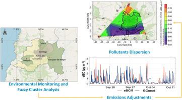
这项工作提出了一种方法,将CALPUFF分散模型与来自化石燃料(BCff, PM2.5ff)和木材燃烧(BCwb, PM2.5wb)的当地黑碳和PM2.5浓度的新估计相结合,以改进当地排放估计,而无需指定边界条件。在2021年的寒冷季节,我们将这种方法应用于智利圣地亚哥的三个郊区——Colina、Melipilla和San jos de Maipo (SJM)。对于PM2.5wb, Colina的当地排放量估计为74.8吨/年,Melipilla为93.3吨/年,SJM为24.3吨/年,分别相当于2012年库存的0.5倍、0.4倍和0.3倍。对于BCff, Colina的估计排放量为2.2吨/月,Melipilla的估计排放量为0.2吨/月,SJM的估计排放量为0.2吨/月,分别是2017年清单中每个站点各自值的5.2倍、0.7倍和2.8倍。对于BCwb和BCff,当地排放峰值对应于一天中住宅燃烧和交通活动水平较高的时间。从B区(研究的郊区)到A区(大圣地亚哥)的BCff分散模型显示,2021年7月凌晨的贡献最大。从A区到B区的PM2.5wb、PM2.5ff、BCwb和BCff弥散模型和风轨迹分析表明,到达研究郊区的非局部贡献不仅来自圣地亚哥,也来自附近和远处的地区。这种新颖的方法可以应用于任何郊区。
A methodology for estimation of local black carbon and PM2.5 emissions in suburban zones. Case study of Santiago, Chile
This work presents a methodology that combines CALPUFF dispersion model with novel estimates of local concentrations of black carbon and PM2.5 coming from fossil fuel (BCff, PM2.5ff) and wood burning (BCwb, PM2.5wb), to improve local emission estimates without the need to specify boundary conditions. We have applied this methodology in three suburbs of Santiago, Chile — Colina, Melipilla and San José de Maipo (SJM) — during the cold season of 2021. For PM2.5wb, local emission rates were estimated at 74.8 ton year−1 for Colina, 93.3 ton year−1 for Melipilla, and 24.3 ton year−1 for SJM, which correspond to 0.5, 0.4, and 0.3 times the 2012 inventory, respectively. For BCff, the estimated emission rates were 2.2 ton month−1 in Colina, 0.2 ton month−1 in Melipilla, and 0.2 ton month−1 in SJM, which represent 5.2, 0.7, and 2.8 times the respective values at each site according to the 2017 inventory. For both BCwb and BCff, the peaks in local emissions corresponded to times of the day with higher levels of residential combustion and traffic activity. Dispersion modeling of BCff from Zone B (the studied suburbs) to Zone A (Greater Santiago) showed that the highest contributions occurred in July 2021 in the wee hours. Dispersion modeling of PM2.5wb, PM2.5ff, BCwb and BCff from Zone A to Zone B and wind trajectory analysis suggest that non-local contributions reaching the studied suburbs originate not only from Santiago but also from nearby and distant localities. This novel methodology may be applied to any suburban area.
期刊介绍:
Atmospheric Pollution Research (APR) is an international journal designed for the publication of articles on air pollution. Papers should present novel experimental results, theory and modeling of air pollution on local, regional, or global scales. Areas covered are research on inorganic, organic, and persistent organic air pollutants, air quality monitoring, air quality management, atmospheric dispersion and transport, air-surface (soil, water, and vegetation) exchange of pollutants, dry and wet deposition, indoor air quality, exposure assessment, health effects, satellite measurements, natural emissions, atmospheric chemistry, greenhouse gases, and effects on climate change.