{"title":"中文地质文本空间关系的联合提取方法","authors":"Chuan Chen, Xiuguo Liu, Weihua Hua, Xinling Zeng, Zihan Cao, Peng Li, Chunyu Qi, Yu Huang, Jiameng Chen, Wencheng Wei","doi":"10.1029/2025EA004335","DOIUrl":null,"url":null,"abstract":"<p>Extracting spatial relations of geological entities is an important prerequisite for achieving natural language processing tasks such as geological knowledge question answering and semantic search, and is an important means to achieve structural reconstruction of unstructured geological data. Geological survey reports are standardized records and representations of geological work results. Geologists have accumulated a large amount of results data in their long-term work practice, which contains rich geological entity attribute information and spatial information. This paper uses regional geological survey reports as data sources to construct a Chinese geological entity spatial relationship corpus and proposes a joint extraction model (GeoESRJE) for geological entity spatial relations. This method regards the two subtasks of entity recognition and relationship extraction as a sequence labeling task, realizes mutual promotion between subtasks, reduces error propagation and information loss, and improves the ability to extract geological entity spatial relations. The spatial relations in the corpus are divided into three categories (topological relations, absolute direction relations, and relative direction relations) and 22 subcategories. We used the test data set to validate the proposed model, and compared with mainstream models, GeoESRJE showed improvements across various evaluation metrics, confirming the effectiveness of the proposed method. Based on the test results, we constructed a knowledge graph of spatial relationships extracted from different themes. By providing a detailed description of these spatial relationships, we laid an important foundation for the mining and analysis of geological knowledge.</p>","PeriodicalId":54286,"journal":{"name":"Earth and Space Science","volume":"12 8","pages":""},"PeriodicalIF":2.6000,"publicationDate":"2025-08-02","publicationTypes":"Journal Article","fieldsOfStudy":null,"isOpenAccess":false,"openAccessPdf":"https://onlinelibrary.wiley.com/doi/epdf/10.1029/2025EA004335","citationCount":"0","resultStr":"{\"title\":\"Joint Extraction Method for Spatial Relations in Chinese Geological Texts\",\"authors\":\"Chuan Chen, Xiuguo Liu, Weihua Hua, Xinling Zeng, Zihan Cao, Peng Li, Chunyu Qi, Yu Huang, Jiameng Chen, Wencheng Wei\",\"doi\":\"10.1029/2025EA004335\",\"DOIUrl\":null,\"url\":null,\"abstract\":\"<p>Extracting spatial relations of geological entities is an important prerequisite for achieving natural language processing tasks such as geological knowledge question answering and semantic search, and is an important means to achieve structural reconstruction of unstructured geological data. Geological survey reports are standardized records and representations of geological work results. Geologists have accumulated a large amount of results data in their long-term work practice, which contains rich geological entity attribute information and spatial information. This paper uses regional geological survey reports as data sources to construct a Chinese geological entity spatial relationship corpus and proposes a joint extraction model (GeoESRJE) for geological entity spatial relations. This method regards the two subtasks of entity recognition and relationship extraction as a sequence labeling task, realizes mutual promotion between subtasks, reduces error propagation and information loss, and improves the ability to extract geological entity spatial relations. The spatial relations in the corpus are divided into three categories (topological relations, absolute direction relations, and relative direction relations) and 22 subcategories. We used the test data set to validate the proposed model, and compared with mainstream models, GeoESRJE showed improvements across various evaluation metrics, confirming the effectiveness of the proposed method. Based on the test results, we constructed a knowledge graph of spatial relationships extracted from different themes. By providing a detailed description of these spatial relationships, we laid an important foundation for the mining and analysis of geological knowledge.</p>\",\"PeriodicalId\":54286,\"journal\":{\"name\":\"Earth and Space Science\",\"volume\":\"12 8\",\"pages\":\"\"},\"PeriodicalIF\":2.6000,\"publicationDate\":\"2025-08-02\",\"publicationTypes\":\"Journal Article\",\"fieldsOfStudy\":null,\"isOpenAccess\":false,\"openAccessPdf\":\"https://onlinelibrary.wiley.com/doi/epdf/10.1029/2025EA004335\",\"citationCount\":\"0\",\"resultStr\":null,\"platform\":\"Semanticscholar\",\"paperid\":null,\"PeriodicalName\":\"Earth and Space Science\",\"FirstCategoryId\":\"89\",\"ListUrlMain\":\"https://agupubs.onlinelibrary.wiley.com/doi/10.1029/2025EA004335\",\"RegionNum\":3,\"RegionCategory\":\"地球科学\",\"ArticlePicture\":[],\"TitleCN\":null,\"AbstractTextCN\":null,\"PMCID\":null,\"EPubDate\":\"\",\"PubModel\":\"\",\"JCR\":\"Q2\",\"JCRName\":\"ASTRONOMY & ASTROPHYSICS\",\"Score\":null,\"Total\":0}","platform":"Semanticscholar","paperid":null,"PeriodicalName":"Earth and Space Science","FirstCategoryId":"89","ListUrlMain":"https://agupubs.onlinelibrary.wiley.com/doi/10.1029/2025EA004335","RegionNum":3,"RegionCategory":"地球科学","ArticlePicture":[],"TitleCN":null,"AbstractTextCN":null,"PMCID":null,"EPubDate":"","PubModel":"","JCR":"Q2","JCRName":"ASTRONOMY & ASTROPHYSICS","Score":null,"Total":0}
Joint Extraction Method for Spatial Relations in Chinese Geological Texts
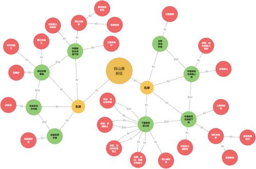
Extracting spatial relations of geological entities is an important prerequisite for achieving natural language processing tasks such as geological knowledge question answering and semantic search, and is an important means to achieve structural reconstruction of unstructured geological data. Geological survey reports are standardized records and representations of geological work results. Geologists have accumulated a large amount of results data in their long-term work practice, which contains rich geological entity attribute information and spatial information. This paper uses regional geological survey reports as data sources to construct a Chinese geological entity spatial relationship corpus and proposes a joint extraction model (GeoESRJE) for geological entity spatial relations. This method regards the two subtasks of entity recognition and relationship extraction as a sequence labeling task, realizes mutual promotion between subtasks, reduces error propagation and information loss, and improves the ability to extract geological entity spatial relations. The spatial relations in the corpus are divided into three categories (topological relations, absolute direction relations, and relative direction relations) and 22 subcategories. We used the test data set to validate the proposed model, and compared with mainstream models, GeoESRJE showed improvements across various evaluation metrics, confirming the effectiveness of the proposed method. Based on the test results, we constructed a knowledge graph of spatial relationships extracted from different themes. By providing a detailed description of these spatial relationships, we laid an important foundation for the mining and analysis of geological knowledge.
期刊介绍:
Marking AGU’s second new open access journal in the last 12 months, Earth and Space Science is the only journal that reflects the expansive range of science represented by AGU’s 62,000 members, including all of the Earth, planetary, and space sciences, and related fields in environmental science, geoengineering, space engineering, and biogeochemistry.


 求助内容:
求助内容: 应助结果提醒方式:


