{"title":"21世纪初塔里木盆地周围冰川变化的区域差异减弱","authors":"Xiaoqian Xu, Wen Wang, Linghong Ke, Pinxuan Zhou","doi":"10.1038/s41612-025-01173-y","DOIUrl":null,"url":null,"abstract":"<p>The Tarim Basin, the largest inland arid basin in the world, is characterized by limited precipitation due to the blocking effect of surrounding mountain ranges. Glaciers in these mountains play a crucial role in regulating the region’s hydrological system. Significant spatial variability in glacier dynamics around the High Mountains Surrounding the Tarim Basin (HMTB) has been documented, with accelerated thinning in the north, moderate thinning in the west, and anomalous mass gain in the south before 2015. However, the temporal dynamics of glacier changes and regional contrasts in the HMTB remain poorly understood due to the scarcity of continuous and consistent observational data. This study investigates glacier changes in the HMTB during 2003–2023 using merged multi-mission satellite altimetry data (ICESat GLAH14, CryoSat-2 L2I, and ICESat-2 ATL06), processed with Seasonal-Trend decomposition based on Loess (STL) to extract long-term trends from seasonal signals. A comparison between 2003–2009 and 2018–2023 reveals a recent weakening of spatial heterogeneity, characterized by accelerated thinning in the southern and western HMTB (e.g., East Kunlun from −0.11 ± 0.04 m yr<sup>−1</sup> to −0.22 ± 0.02 m yr<sup>−1</sup>; Pamir from −0.23 ± 0.05 m yr<sup>−1</sup> to −0.35 ± 0.02 m yr<sup>−1</sup>), reduced elevation gains in “Karakoram Anomaly” regions (e.g., West Kunlun from +0.19 ± 0.02 m yr<sup>−1</sup> to +0.06 ± 0.01 m yr<sup>−1</sup>), and decelerated thinning in the northern HMTB (e.g., East Tien Shan from −0.60 ± 0.06 m yr<sup>−1</sup> to −0.52 ± 0.03 m yr<sup>−1</sup>). This decrease in spatial heterogeneity may drive by declining winter-spring snowfall and intensified summer warming in the south and west, coupled with a slowdown autumn warming and increased spring snowfall in the north. However, the coarse spatial resolution of CryoSat-2 limits the construction of a continuous glacier monitoring time series at finer grid scales, hindering further detailed analysis of small-scale dynamics. Despite these limitations, our study provides important baseline data for future glacier change predictions and water resource planning.</p>","PeriodicalId":19438,"journal":{"name":"npj Climate and Atmospheric Science","volume":"50 1","pages":""},"PeriodicalIF":8.4000,"publicationDate":"2025-07-31","publicationTypes":"Journal Article","fieldsOfStudy":null,"isOpenAccess":false,"openAccessPdf":"","citationCount":"0","resultStr":"{\"title\":\"Weakening of regional contrasts in glacier changes around the Tarim Basin in the early 21st century\",\"authors\":\"Xiaoqian Xu, Wen Wang, Linghong Ke, Pinxuan Zhou\",\"doi\":\"10.1038/s41612-025-01173-y\",\"DOIUrl\":null,\"url\":null,\"abstract\":\"<p>The Tarim Basin, the largest inland arid basin in the world, is characterized by limited precipitation due to the blocking effect of surrounding mountain ranges. Glaciers in these mountains play a crucial role in regulating the region’s hydrological system. Significant spatial variability in glacier dynamics around the High Mountains Surrounding the Tarim Basin (HMTB) has been documented, with accelerated thinning in the north, moderate thinning in the west, and anomalous mass gain in the south before 2015. However, the temporal dynamics of glacier changes and regional contrasts in the HMTB remain poorly understood due to the scarcity of continuous and consistent observational data. This study investigates glacier changes in the HMTB during 2003–2023 using merged multi-mission satellite altimetry data (ICESat GLAH14, CryoSat-2 L2I, and ICESat-2 ATL06), processed with Seasonal-Trend decomposition based on Loess (STL) to extract long-term trends from seasonal signals. A comparison between 2003–2009 and 2018–2023 reveals a recent weakening of spatial heterogeneity, characterized by accelerated thinning in the southern and western HMTB (e.g., East Kunlun from −0.11 ± 0.04 m yr<sup>−1</sup> to −0.22 ± 0.02 m yr<sup>−1</sup>; Pamir from −0.23 ± 0.05 m yr<sup>−1</sup> to −0.35 ± 0.02 m yr<sup>−1</sup>), reduced elevation gains in “Karakoram Anomaly” regions (e.g., West Kunlun from +0.19 ± 0.02 m yr<sup>−1</sup> to +0.06 ± 0.01 m yr<sup>−1</sup>), and decelerated thinning in the northern HMTB (e.g., East Tien Shan from −0.60 ± 0.06 m yr<sup>−1</sup> to −0.52 ± 0.03 m yr<sup>−1</sup>). This decrease in spatial heterogeneity may drive by declining winter-spring snowfall and intensified summer warming in the south and west, coupled with a slowdown autumn warming and increased spring snowfall in the north. However, the coarse spatial resolution of CryoSat-2 limits the construction of a continuous glacier monitoring time series at finer grid scales, hindering further detailed analysis of small-scale dynamics. Despite these limitations, our study provides important baseline data for future glacier change predictions and water resource planning.</p>\",\"PeriodicalId\":19438,\"journal\":{\"name\":\"npj Climate and Atmospheric Science\",\"volume\":\"50 1\",\"pages\":\"\"},\"PeriodicalIF\":8.4000,\"publicationDate\":\"2025-07-31\",\"publicationTypes\":\"Journal Article\",\"fieldsOfStudy\":null,\"isOpenAccess\":false,\"openAccessPdf\":\"\",\"citationCount\":\"0\",\"resultStr\":null,\"platform\":\"Semanticscholar\",\"paperid\":null,\"PeriodicalName\":\"npj Climate and Atmospheric Science\",\"FirstCategoryId\":\"89\",\"ListUrlMain\":\"https://doi.org/10.1038/s41612-025-01173-y\",\"RegionNum\":1,\"RegionCategory\":\"地球科学\",\"ArticlePicture\":[],\"TitleCN\":null,\"AbstractTextCN\":null,\"PMCID\":null,\"EPubDate\":\"\",\"PubModel\":\"\",\"JCR\":\"Q1\",\"JCRName\":\"METEOROLOGY & ATMOSPHERIC SCIENCES\",\"Score\":null,\"Total\":0}","platform":"Semanticscholar","paperid":null,"PeriodicalName":"npj Climate and Atmospheric Science","FirstCategoryId":"89","ListUrlMain":"https://doi.org/10.1038/s41612-025-01173-y","RegionNum":1,"RegionCategory":"地球科学","ArticlePicture":[],"TitleCN":null,"AbstractTextCN":null,"PMCID":null,"EPubDate":"","PubModel":"","JCR":"Q1","JCRName":"METEOROLOGY & ATMOSPHERIC SCIENCES","Score":null,"Total":0}
引用次数: 0
摘要
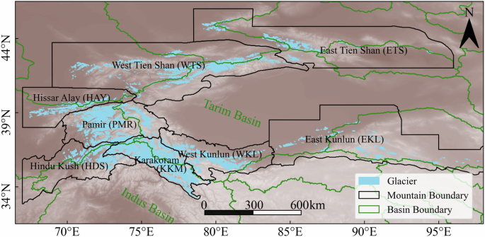
塔里木盆地是世界上最大的内陆干旱盆地,由于周围山脉的阻隔作用,降水有限。这些山区的冰川在调节该地区的水文系统方面发挥着至关重要的作用。2015年以前,塔里木盆地高海拔地区冰川动态呈现显著的空间变异性,北部冰川加速减薄,西部冰川适度减薄,南部冰川质量异常增加。然而,由于缺乏连续和一致的观测数据,对HMTB冰川变化的时间动态和区域对比仍然知之甚少。本研究利用合并的多任务卫星测高数据(ICESat GLAH14、CryoSat-2 L2I和ICESat-2 ATL06),对2003-2023年HMTB冰川变化进行了研究,并进行了基于黄土的季节趋势分解(STL)处理,从季节信号中提取长期趋势。2003-2009年与2018-2023年的对比表明,近年来空间异质性减弱,其特征是HMTB南部和西部加速变薄(例如,东昆仑从- 0.11±0.04 m yr - 1增加到- 0.22±0.02 m yr - 1;帕米尔高原从- 0.23±0.05 m yr - 1降至- 0.35±0.02 m yr - 1),“喀喇昆仑异常”地区的海拔增加减少(例如,西昆仑从+0.19±0.02 m yr - 1降至+0.06±0.01 m yr - 1), HMTB北部的减薄减慢(例如,东天山从- 0.60±0.06 m yr - 1降至- 0.52±0.03 m yr - 1)。这种空间异质性的减弱可能是由南部和西部冬春降雪量减少和夏季增温加剧,以及北部秋季增温放缓和春季降雪量增加所驱动的。然而,CryoSat-2的粗空间分辨率限制了在更细网格尺度上构建连续冰川监测时间序列,阻碍了对小尺度动态的进一步详细分析。尽管存在这些局限性,我们的研究为未来冰川变化预测和水资源规划提供了重要的基线数据。
Weakening of regional contrasts in glacier changes around the Tarim Basin in the early 21st century
The Tarim Basin, the largest inland arid basin in the world, is characterized by limited precipitation due to the blocking effect of surrounding mountain ranges. Glaciers in these mountains play a crucial role in regulating the region’s hydrological system. Significant spatial variability in glacier dynamics around the High Mountains Surrounding the Tarim Basin (HMTB) has been documented, with accelerated thinning in the north, moderate thinning in the west, and anomalous mass gain in the south before 2015. However, the temporal dynamics of glacier changes and regional contrasts in the HMTB remain poorly understood due to the scarcity of continuous and consistent observational data. This study investigates glacier changes in the HMTB during 2003–2023 using merged multi-mission satellite altimetry data (ICESat GLAH14, CryoSat-2 L2I, and ICESat-2 ATL06), processed with Seasonal-Trend decomposition based on Loess (STL) to extract long-term trends from seasonal signals. A comparison between 2003–2009 and 2018–2023 reveals a recent weakening of spatial heterogeneity, characterized by accelerated thinning in the southern and western HMTB (e.g., East Kunlun from −0.11 ± 0.04 m yr−1 to −0.22 ± 0.02 m yr−1; Pamir from −0.23 ± 0.05 m yr−1 to −0.35 ± 0.02 m yr−1), reduced elevation gains in “Karakoram Anomaly” regions (e.g., West Kunlun from +0.19 ± 0.02 m yr−1 to +0.06 ± 0.01 m yr−1), and decelerated thinning in the northern HMTB (e.g., East Tien Shan from −0.60 ± 0.06 m yr−1 to −0.52 ± 0.03 m yr−1). This decrease in spatial heterogeneity may drive by declining winter-spring snowfall and intensified summer warming in the south and west, coupled with a slowdown autumn warming and increased spring snowfall in the north. However, the coarse spatial resolution of CryoSat-2 limits the construction of a continuous glacier monitoring time series at finer grid scales, hindering further detailed analysis of small-scale dynamics. Despite these limitations, our study provides important baseline data for future glacier change predictions and water resource planning.
期刊介绍:
npj Climate and Atmospheric Science is an open-access journal encompassing the relevant physical, chemical, and biological aspects of atmospheric and climate science. The journal places particular emphasis on regional studies that unveil new insights into specific localities, including examinations of local atmospheric composition, such as aerosols.
The range of topics covered by the journal includes climate dynamics, climate variability, weather and climate prediction, climate change, ocean dynamics, weather extremes, air pollution, atmospheric chemistry (including aerosols), the hydrological cycle, and atmosphere–ocean and atmosphere–land interactions. The journal welcomes studies employing a diverse array of methods, including numerical and statistical modeling, the development and application of in situ observational techniques, remote sensing, and the development or evaluation of new reanalyses.
 求助内容:
求助内容: 应助结果提醒方式:


