水下区域对地貌多样性的影响:以波兰中北部Wielkopolska湖区为例

IF 8 1区 环境科学与生态学 Q1 ENVIRONMENTAL SCIENCES
Rafał Kot , Paweł Molewski
{"title":"水下区域对地貌多样性的影响:以波兰中北部Wielkopolska湖区为例","authors":"Rafał Kot ,&nbsp;Paweł Molewski","doi":"10.1016/j.scitotenv.2025.180127","DOIUrl":null,"url":null,"abstract":"<div><div>The main research objective was to assess geomorphodiversity – a key component of geodiversity – in a selected lowland area, including its subaqueous parts. The research also aimed to identify whether subaqueous areas influence landscape geodiversity. The subject of analysis was part of a lakeland in northern Poland that includes several large lakes. The variables (including parameters, indicators, metrics) used to assess geomorphodiversity, were selected objectively by performing a statistical analysis of 110 variables selected according to six methodological types of geodiversity studies. Ultimately, nine diverse variables were selected that lacked strong mutual correlations. Seven showed varying degrees of influence of subaqueous areas on geomorphodiversity, while the remaining ones turned out to be inappropriate for analyses in lowland areas. The highest results among the various assessments of geomorphodiversity for subaqueous areas were obtained for those variables calculated using landscape metrics and multi-criterion assessments. Previous studies on geomorphodiversity have primarily focused on terrestrial landscapes, excluding underwater areas such as lake beds. This study aims to fill that gap by incorporating both terrestrial and underwater landforms into a comprehensive framework for assessing geomorphodiversity. The provision of access to bathymetric plans has improved, as have modern technologies for identifying the bed morphology of water bodies. These improvements should encourage researchers to take such resources into account in geodiversity assessments. We conclude that omitting subaqueous areas from geodiversity analyses significantly limits the comprehensiveness of assessment of the natural environment, especially in the context of geoconservation, geoheritage, geomanagement and provision of ecosystem and geosystem services.</div></div>","PeriodicalId":422,"journal":{"name":"Science of the Total Environment","volume":"996 ","pages":"Article 180127"},"PeriodicalIF":8.0000,"publicationDate":"2025-07-29","publicationTypes":"Journal Article","fieldsOfStudy":null,"isOpenAccess":false,"openAccessPdf":"","citationCount":"0","resultStr":"{\"title\":\"The impact of subaqueous areas on geomorphodiversity: A case study within the Wielkopolska Lakeland, northern central Poland\",\"authors\":\"Rafał Kot ,&nbsp;Paweł Molewski\",\"doi\":\"10.1016/j.scitotenv.2025.180127\",\"DOIUrl\":null,\"url\":null,\"abstract\":\"<div><div>The main research objective was to assess geomorphodiversity – a key component of geodiversity – in a selected lowland area, including its subaqueous parts. The research also aimed to identify whether subaqueous areas influence landscape geodiversity. The subject of analysis was part of a lakeland in northern Poland that includes several large lakes. The variables (including parameters, indicators, metrics) used to assess geomorphodiversity, were selected objectively by performing a statistical analysis of 110 variables selected according to six methodological types of geodiversity studies. Ultimately, nine diverse variables were selected that lacked strong mutual correlations. Seven showed varying degrees of influence of subaqueous areas on geomorphodiversity, while the remaining ones turned out to be inappropriate for analyses in lowland areas. The highest results among the various assessments of geomorphodiversity for subaqueous areas were obtained for those variables calculated using landscape metrics and multi-criterion assessments. Previous studies on geomorphodiversity have primarily focused on terrestrial landscapes, excluding underwater areas such as lake beds. This study aims to fill that gap by incorporating both terrestrial and underwater landforms into a comprehensive framework for assessing geomorphodiversity. The provision of access to bathymetric plans has improved, as have modern technologies for identifying the bed morphology of water bodies. These improvements should encourage researchers to take such resources into account in geodiversity assessments. We conclude that omitting subaqueous areas from geodiversity analyses significantly limits the comprehensiveness of assessment of the natural environment, especially in the context of geoconservation, geoheritage, geomanagement and provision of ecosystem and geosystem services.</div></div>\",\"PeriodicalId\":422,\"journal\":{\"name\":\"Science of the Total Environment\",\"volume\":\"996 \",\"pages\":\"Article 180127\"},\"PeriodicalIF\":8.0000,\"publicationDate\":\"2025-07-29\",\"publicationTypes\":\"Journal Article\",\"fieldsOfStudy\":null,\"isOpenAccess\":false,\"openAccessPdf\":\"\",\"citationCount\":\"0\",\"resultStr\":null,\"platform\":\"Semanticscholar\",\"paperid\":null,\"PeriodicalName\":\"Science of the Total Environment\",\"FirstCategoryId\":\"93\",\"ListUrlMain\":\"https://www.sciencedirect.com/science/article/pii/S004896972501767X\",\"RegionNum\":1,\"RegionCategory\":\"环境科学与生态学\",\"ArticlePicture\":[],\"TitleCN\":null,\"AbstractTextCN\":null,\"PMCID\":null,\"EPubDate\":\"\",\"PubModel\":\"\",\"JCR\":\"Q1\",\"JCRName\":\"ENVIRONMENTAL SCIENCES\",\"Score\":null,\"Total\":0}","platform":"Semanticscholar","paperid":null,"PeriodicalName":"Science of the Total Environment","FirstCategoryId":"93","ListUrlMain":"https://www.sciencedirect.com/science/article/pii/S004896972501767X","RegionNum":1,"RegionCategory":"环境科学与生态学","ArticlePicture":[],"TitleCN":null,"AbstractTextCN":null,"PMCID":null,"EPubDate":"","PubModel":"","JCR":"Q1","JCRName":"ENVIRONMENTAL SCIENCES","Score":null,"Total":0}
引用次数: 0

摘要

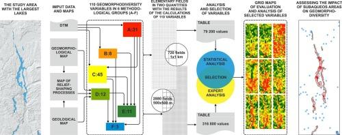
主要的研究目标是评估选定的低地地区,包括其水下部分的地貌多样性- -地质多样性的一个关键组成部分。该研究还旨在确定水下区域是否影响景观地质多样性。分析的对象是波兰北部一个湖区的一部分,其中包括几个大湖。根据地质多样性研究的6种方法类型,对110个变量进行统计分析,客观地选择了用于评价地貌多样性的变量(包括参数、指标、度量)。最终,选择了9个缺乏强相互相关性的不同变量。其中7项研究显示水下区域对地貌多样性有不同程度的影响,其余的研究不适合在低地地区进行分析。在各种水下区域地貌多样性评价中,使用景观指标和多准则评价计算的变量获得了最高的结果。以往对地貌多样性的研究主要集中在陆地景观上,不包括湖床等水下区域。本研究旨在通过将陆地和水下地貌纳入评估地貌多样性的综合框架来填补这一空白。取得测深图的机会有所改善,查明水体河床形态的现代技术也有所改善。这些改进应鼓励研究人员在评估地质多样性时考虑到这些资源。我们的结论是,在地质多样性分析中忽略水下区域严重限制了自然环境评估的全面性,特别是在地质保护、地质遗产、地质管理以及提供生态系统和地质系统服务的背景下。
本文章由计算机程序翻译,如有差异,请以英文原文为准。

The impact of subaqueous areas on geomorphodiversity: A case study within the Wielkopolska Lakeland, northern central Poland

The impact of subaqueous areas on geomorphodiversity: A case study within the Wielkopolska Lakeland, northern central Poland
The main research objective was to assess geomorphodiversity – a key component of geodiversity – in a selected lowland area, including its subaqueous parts. The research also aimed to identify whether subaqueous areas influence landscape geodiversity. The subject of analysis was part of a lakeland in northern Poland that includes several large lakes. The variables (including parameters, indicators, metrics) used to assess geomorphodiversity, were selected objectively by performing a statistical analysis of 110 variables selected according to six methodological types of geodiversity studies. Ultimately, nine diverse variables were selected that lacked strong mutual correlations. Seven showed varying degrees of influence of subaqueous areas on geomorphodiversity, while the remaining ones turned out to be inappropriate for analyses in lowland areas. The highest results among the various assessments of geomorphodiversity for subaqueous areas were obtained for those variables calculated using landscape metrics and multi-criterion assessments. Previous studies on geomorphodiversity have primarily focused on terrestrial landscapes, excluding underwater areas such as lake beds. This study aims to fill that gap by incorporating both terrestrial and underwater landforms into a comprehensive framework for assessing geomorphodiversity. The provision of access to bathymetric plans has improved, as have modern technologies for identifying the bed morphology of water bodies. These improvements should encourage researchers to take such resources into account in geodiversity assessments. We conclude that omitting subaqueous areas from geodiversity analyses significantly limits the comprehensiveness of assessment of the natural environment, especially in the context of geoconservation, geoheritage, geomanagement and provision of ecosystem and geosystem services.
求助全文
通过发布文献求助,成功后即可免费获取论文全文。 去求助
来源期刊
Science of the Total Environment
Science of the Total Environment 环境科学-环境科学
CiteScore
17.60
自引率
10.20%
发文量
8726
审稿时长
2.4 months
期刊介绍: The Science of the Total Environment is an international journal dedicated to scientific research on the environment and its interaction with humanity. It covers a wide range of disciplines and seeks to publish innovative, hypothesis-driven, and impactful research that explores the entire environment, including the atmosphere, lithosphere, hydrosphere, biosphere, and anthroposphere. The journal's updated Aims & Scope emphasizes the importance of interdisciplinary environmental research with broad impact. Priority is given to studies that advance fundamental understanding and explore the interconnectedness of multiple environmental spheres. Field studies are preferred, while laboratory experiments must demonstrate significant methodological advancements or mechanistic insights with direct relevance to the environment.
×
引用
GB/T 7714-2015
复制
MLA
复制
APA
复制
导出至
BibTeX EndNote RefMan NoteFirst NoteExpress
×
提示
您的信息不完整,为了账户安全,请先补充。
现在去补充
×
提示
您因"违规操作"
具体请查看互助需知
我知道了
×
提示
确定
请完成安全验证×
copy
已复制链接
快去分享给好友吧!
我知道了
右上角分享
点击右上角分享
0
联系我们:info@booksci.cn Book学术提供免费学术资源搜索服务,方便国内外学者检索中英文文献。致力于提供最便捷和优质的服务体验。 Copyright © 2023 布克学术 All rights reserved.
京ICP备2023020795号-1
ghs 京公网安备 11010802042870号
Book学术文献互助
Book学术文献互助群
群 号:604180095
Book学术官方微信