2023年长江-淮河流域梅雨的特征及可能原因
IF 3.2
4区 地球科学
Q3 METEOROLOGY & ATMOSPHERIC SCIENCES
引用次数: 0
摘要
2023年长江-淮河流域梅雨降水呈现起退晚、持续时间短、低于正常值的特征。5月下旬至6月上旬中高纬度南下的较弱冷空气导致梅雨季节推迟到来,台风“塔利姆”和超级台风“独瑞”带来的持续降雨导致梅雨季节推迟撤退。西太平洋副热带高压(WPSH)向西移动增强,加上南亚高压(SAH)向东移动增强,以及欧亚中高纬环流“两槽一脊”,造成梅雨降水低于平均水平,降水主要集中在东海东部。进一步分析表明,2023年的梅雨是受La Niña衰减、北太平洋西风漂移区海温异常和青藏高原积雪不足的综合影响。西太平洋暖池和北太平洋西风漂移区海温偏暖有利于中纬度狭窄经向环流和西太平洋高压,而南亚高压增强和东亚夏季风则受到青藏高原东北部积雪持续减少的影响。摘要2023年中国江淮流域入梅和出梅日期均偏晚, 梅雨量整体偏少. 本文研究发现, 5月末6月初中高纬冷空气偏弱是入梅偏晚的原因, 台风“泰利”和强台风“杜苏芮”引起的持续性降水导致了出梅偏晚. 中低纬地区偏西偏强的西太平洋副热带高压和偏东偏强的南亚高压叠置, 配合欧亚中高纬 “两槽一脊”环流型, 使得江淮流域梅雨量偏少, 且降水集中在江淮流域东部. 进一步分析表明,2023年梅雨期中国受拉尼娜衰减位相的影响,西太平洋暖池和北太平洋西风漂流区的暖海温异常导致中纬度环流经向性偏弱,西太平洋副热带高压偏,西偏强。而南亚高压和东亚夏季风异常主要受到青藏高原东北部积雪持续异常偏少的影响.本文章由计算机程序翻译,如有差异,请以英文原文为准。
Characteristics and possible causes of the Meiyu over the Yangtze–Huaihe River Basin in 2023
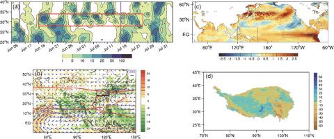
The Meiyu in the Yangtze–Huaihe River basin (YHRB) in 2023 was featured by delayed onset and retreat, a shorter duration, and below-normal Meiyu precipitation. The relatively weak cold air invading southward from the mid-to-high latitudes in late May–early June contributed to the delayed onset of Meiyu season, and the persistent rainfall caused by Typhoon “Talim” and Super Typhoon “Doksuri” led to the delayed retreat. The westward-shifted and intensified western Pacific subtropical high (WPSH), coupled with the eastward-shifted and strengthened south Asian high (SAH), as well as the Eurasian mid-to-high latitude circulation featuring “two troughs–one ridge”, resulting in the below-average Meiyu precipitation with the heaviest rainfall primally in eastern YHRB. Further analysis indicates that the 2023 Meiyu was influenced by the combined effects of the decaying La Niña, warm sea surface temperature (SST) anomalies in the North Pacific west wind drift area, and less than normal snow cover over the Tibetan Plateau. Warmer than normal SST in the western Pacific warm pool and the North Pacific westerly drift region favored the narrow meridional circulation at middle latitudes and WPSH, whereas the strengthened SAH and East Asian summer monsoon were impacted by persistently reduced snow cover over the northeastern Tibetan Plateau.
摘要
2023年中国江淮流域入梅和出梅日期均偏晚, 梅雨量整体偏少. 本文研究发现, 5月末6月初中高纬冷空气偏弱是入梅偏晚的原因, 台风“泰利”和强台风“杜苏芮”引起的持续性降水导致了出梅偏晚. 中低纬地区偏西偏强的西太平洋副热带高压和偏东偏强的南亚高压叠置, 配合欧亚中高纬 “两槽一脊”环流型, 使得江淮流域梅雨量偏少, 且降水集中在江淮流域东部. 进一步分析表明, 2023年梅雨期中国受La Niña 衰减位相的影响, 西太平洋暖池和北太平洋西风漂流区的暖海温异常导致中纬度环流经向性偏弱, 西太平洋副热带高压偏西, 偏强. 而南亚高压和东亚夏季风异常主要受到青藏高原东北部积雪持续异常偏少的影响.
求助全文
通过发布文献求助,成功后即可免费获取论文全文。
去求助
来源期刊
Atmospheric and Oceanic Science Letters
METEOROLOGY & ATMOSPHERIC SCIENCES-
CiteScore
4.20
自引率
8.70%
发文量
925
审稿时长
12 weeks
 求助内容:
求助内容: 应助结果提醒方式:


