Jun-Hak Lee, Seungsoo Lee, Bomi Kim, Hyeonjin Choi, Seong Jin Noh
{"title":"城市建成环境中空间分辨率对二维洪积洪水模型的影响评价","authors":"Jun-Hak Lee, Seungsoo Lee, Bomi Kim, Hyeonjin Choi, Seong Jin Noh","doi":"10.1111/jfr3.70105","DOIUrl":null,"url":null,"abstract":"<p>This study examines the impact of spatial resolution on urban pluvial flood modeling, emphasizing the role of high-resolution topographic data in flood inundation mapping. Using the physically-based H12 urban flood model, we simulated the December 6–8, 2015, pluvial flood event in a sub-watershed in Portland, Oregon. We compared the temporal evolution of inundation maps from a benchmark 1 m resolution model with coarser resolutions (2–50 m) and assessed accuracy using water depth error measures and grid-based inundation extent metrics. Our results indicate that accumulated inundated water volume increases significantly with coarser grid resolutions, leading to larger discrepancies in flood extent. Coarser grids generally overpredict inundation extents, except in the 2 m model. Accuracy metrics decline with resolution coarsening, with the hit rate (<i>H</i>) dropping below 0.7 and the critical success index (<i>C</i>) falling to 0.5 or lower beyond 7 m resolution. Multi-directional flow path analyses reveal that inundation extent expands with coarser resolutions, while computational efficiency improves. The primary source of accuracy degradation is the inability of coarse grids to capture key urban topographical details, such as road networks, which influence floodwater movement. While no single optimal resolution applies universally, grid resolutions must be fine enough to accurately represent major urban features critical to flood dynamics.</p>","PeriodicalId":49294,"journal":{"name":"Journal of Flood Risk Management","volume":"18 3","pages":""},"PeriodicalIF":3.0000,"publicationDate":"2025-07-23","publicationTypes":"Journal Article","fieldsOfStudy":null,"isOpenAccess":false,"openAccessPdf":"https://onlinelibrary.wiley.com/doi/epdf/10.1111/jfr3.70105","citationCount":"0","resultStr":"{\"title\":\"Evaluating the Effects of Spatial Resolution on 2D Pluvial Flood Modeling in Urban Built Environments\",\"authors\":\"Jun-Hak Lee, Seungsoo Lee, Bomi Kim, Hyeonjin Choi, Seong Jin Noh\",\"doi\":\"10.1111/jfr3.70105\",\"DOIUrl\":null,\"url\":null,\"abstract\":\"<p>This study examines the impact of spatial resolution on urban pluvial flood modeling, emphasizing the role of high-resolution topographic data in flood inundation mapping. Using the physically-based H12 urban flood model, we simulated the December 6–8, 2015, pluvial flood event in a sub-watershed in Portland, Oregon. We compared the temporal evolution of inundation maps from a benchmark 1 m resolution model with coarser resolutions (2–50 m) and assessed accuracy using water depth error measures and grid-based inundation extent metrics. Our results indicate that accumulated inundated water volume increases significantly with coarser grid resolutions, leading to larger discrepancies in flood extent. Coarser grids generally overpredict inundation extents, except in the 2 m model. Accuracy metrics decline with resolution coarsening, with the hit rate (<i>H</i>) dropping below 0.7 and the critical success index (<i>C</i>) falling to 0.5 or lower beyond 7 m resolution. Multi-directional flow path analyses reveal that inundation extent expands with coarser resolutions, while computational efficiency improves. The primary source of accuracy degradation is the inability of coarse grids to capture key urban topographical details, such as road networks, which influence floodwater movement. While no single optimal resolution applies universally, grid resolutions must be fine enough to accurately represent major urban features critical to flood dynamics.</p>\",\"PeriodicalId\":49294,\"journal\":{\"name\":\"Journal of Flood Risk Management\",\"volume\":\"18 3\",\"pages\":\"\"},\"PeriodicalIF\":3.0000,\"publicationDate\":\"2025-07-23\",\"publicationTypes\":\"Journal Article\",\"fieldsOfStudy\":null,\"isOpenAccess\":false,\"openAccessPdf\":\"https://onlinelibrary.wiley.com/doi/epdf/10.1111/jfr3.70105\",\"citationCount\":\"0\",\"resultStr\":null,\"platform\":\"Semanticscholar\",\"paperid\":null,\"PeriodicalName\":\"Journal of Flood Risk Management\",\"FirstCategoryId\":\"93\",\"ListUrlMain\":\"https://onlinelibrary.wiley.com/doi/10.1111/jfr3.70105\",\"RegionNum\":3,\"RegionCategory\":\"环境科学与生态学\",\"ArticlePicture\":[],\"TitleCN\":null,\"AbstractTextCN\":null,\"PMCID\":null,\"EPubDate\":\"\",\"PubModel\":\"\",\"JCR\":\"Q2\",\"JCRName\":\"ENVIRONMENTAL SCIENCES\",\"Score\":null,\"Total\":0}","platform":"Semanticscholar","paperid":null,"PeriodicalName":"Journal of Flood Risk Management","FirstCategoryId":"93","ListUrlMain":"https://onlinelibrary.wiley.com/doi/10.1111/jfr3.70105","RegionNum":3,"RegionCategory":"环境科学与生态学","ArticlePicture":[],"TitleCN":null,"AbstractTextCN":null,"PMCID":null,"EPubDate":"","PubModel":"","JCR":"Q2","JCRName":"ENVIRONMENTAL SCIENCES","Score":null,"Total":0}
Evaluating the Effects of Spatial Resolution on 2D Pluvial Flood Modeling in Urban Built Environments
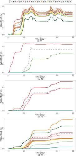
This study examines the impact of spatial resolution on urban pluvial flood modeling, emphasizing the role of high-resolution topographic data in flood inundation mapping. Using the physically-based H12 urban flood model, we simulated the December 6–8, 2015, pluvial flood event in a sub-watershed in Portland, Oregon. We compared the temporal evolution of inundation maps from a benchmark 1 m resolution model with coarser resolutions (2–50 m) and assessed accuracy using water depth error measures and grid-based inundation extent metrics. Our results indicate that accumulated inundated water volume increases significantly with coarser grid resolutions, leading to larger discrepancies in flood extent. Coarser grids generally overpredict inundation extents, except in the 2 m model. Accuracy metrics decline with resolution coarsening, with the hit rate (H) dropping below 0.7 and the critical success index (C) falling to 0.5 or lower beyond 7 m resolution. Multi-directional flow path analyses reveal that inundation extent expands with coarser resolutions, while computational efficiency improves. The primary source of accuracy degradation is the inability of coarse grids to capture key urban topographical details, such as road networks, which influence floodwater movement. While no single optimal resolution applies universally, grid resolutions must be fine enough to accurately represent major urban features critical to flood dynamics.
期刊介绍:
Journal of Flood Risk Management provides an international platform for knowledge sharing in all areas related to flood risk. Its explicit aim is to disseminate ideas across the range of disciplines where flood related research is carried out and it provides content ranging from leading edge academic papers to applied content with the practitioner in mind.
Readers and authors come from a wide background and include hydrologists, meteorologists, geographers, geomorphologists, conservationists, civil engineers, social scientists, policy makers, insurers and practitioners. They share an interest in managing the complex interactions between the many skills and disciplines that underpin the management of flood risk across the world.

 求助内容:
求助内容: 应助结果提醒方式:


