Florian Weidinger, Sarah Matej, Lukas Baumbach, Thomas Hickler, Christian Werner, Karl-Heinz Erb
{"title":"全球潜在净初级产量的简约降尺度方法:从30角秒分辨率到30角秒分辨率","authors":"Florian Weidinger, Sarah Matej, Lukas Baumbach, Thomas Hickler, Christian Werner, Karl-Heinz Erb","doi":"10.1029/2025JG009019","DOIUrl":null,"url":null,"abstract":"<p>The impact of land use on ecosystems has reached critical levels, jeopardizing biosphere integrity. A key indicator that quantifies, monitors, and analyses such impacts is the Human Appropriation of Net Primary Production (HANPP). Assessing HANPP consists of a comparison of actual net primary production and potential vegetation properties—i.e., vegetation properties that would prevail in the absence of land use (i.e., the NPP of the potential vegetation; NPPpot). While technical advancements in remote sensing have led to global land cover data at high spatial resolution up to 30 arcsec (i.e., 1 km at the equator) and higher, spatial explicit global NPPpot, mainly provided by Dynamic Global Vegetation Models (DGVMs), are usually generated at 30 arcmin (i.e., 55 km at the equator). This spatial mismatch causes uncertainties in HANPP assessments. We here present a workable solution for downscaling NPPpot until global, high-resolution results, for example, from DGVMs, become feasible. This method uses a simple NPPpot model with readily available auxiliary information at higher spatial resolution to generate fine-scale patterns to downscale high-quality coarse scale NPPpot. It includes a smoothing procedure to reduce downscaling artifacts. We demonstrate this Smooth Auxiliary Data (SAD) downscaling by applying it to NPPpot results from the LPJ-GUESS DGVM model for the year 2010 to downscale from 30 arcmin to 30 arcsec resolution. This approach generates fine-scaled NPPpot patterns and aligns with alternative models for smaller geographic units while computational cost is acceptable.</p>","PeriodicalId":16003,"journal":{"name":"Journal of Geophysical Research: Biogeosciences","volume":"130 7","pages":""},"PeriodicalIF":3.5000,"publicationDate":"2025-07-22","publicationTypes":"Journal Article","fieldsOfStudy":null,"isOpenAccess":false,"openAccessPdf":"https://onlinelibrary.wiley.com/doi/epdf/10.1029/2025JG009019","citationCount":"0","resultStr":"{\"title\":\"A Parsimonious Downscaling Method for Global Potential Net Primary Production: From 30 arcmin to 30 arcsec Resolution\",\"authors\":\"Florian Weidinger, Sarah Matej, Lukas Baumbach, Thomas Hickler, Christian Werner, Karl-Heinz Erb\",\"doi\":\"10.1029/2025JG009019\",\"DOIUrl\":null,\"url\":null,\"abstract\":\"<p>The impact of land use on ecosystems has reached critical levels, jeopardizing biosphere integrity. A key indicator that quantifies, monitors, and analyses such impacts is the Human Appropriation of Net Primary Production (HANPP). Assessing HANPP consists of a comparison of actual net primary production and potential vegetation properties—i.e., vegetation properties that would prevail in the absence of land use (i.e., the NPP of the potential vegetation; NPPpot). While technical advancements in remote sensing have led to global land cover data at high spatial resolution up to 30 arcsec (i.e., 1 km at the equator) and higher, spatial explicit global NPPpot, mainly provided by Dynamic Global Vegetation Models (DGVMs), are usually generated at 30 arcmin (i.e., 55 km at the equator). This spatial mismatch causes uncertainties in HANPP assessments. We here present a workable solution for downscaling NPPpot until global, high-resolution results, for example, from DGVMs, become feasible. This method uses a simple NPPpot model with readily available auxiliary information at higher spatial resolution to generate fine-scale patterns to downscale high-quality coarse scale NPPpot. It includes a smoothing procedure to reduce downscaling artifacts. We demonstrate this Smooth Auxiliary Data (SAD) downscaling by applying it to NPPpot results from the LPJ-GUESS DGVM model for the year 2010 to downscale from 30 arcmin to 30 arcsec resolution. This approach generates fine-scaled NPPpot patterns and aligns with alternative models for smaller geographic units while computational cost is acceptable.</p>\",\"PeriodicalId\":16003,\"journal\":{\"name\":\"Journal of Geophysical Research: Biogeosciences\",\"volume\":\"130 7\",\"pages\":\"\"},\"PeriodicalIF\":3.5000,\"publicationDate\":\"2025-07-22\",\"publicationTypes\":\"Journal Article\",\"fieldsOfStudy\":null,\"isOpenAccess\":false,\"openAccessPdf\":\"https://onlinelibrary.wiley.com/doi/epdf/10.1029/2025JG009019\",\"citationCount\":\"0\",\"resultStr\":null,\"platform\":\"Semanticscholar\",\"paperid\":null,\"PeriodicalName\":\"Journal of Geophysical Research: Biogeosciences\",\"FirstCategoryId\":\"93\",\"ListUrlMain\":\"https://agupubs.onlinelibrary.wiley.com/doi/10.1029/2025JG009019\",\"RegionNum\":3,\"RegionCategory\":\"环境科学与生态学\",\"ArticlePicture\":[],\"TitleCN\":null,\"AbstractTextCN\":null,\"PMCID\":null,\"EPubDate\":\"\",\"PubModel\":\"\",\"JCR\":\"Q2\",\"JCRName\":\"ENVIRONMENTAL SCIENCES\",\"Score\":null,\"Total\":0}","platform":"Semanticscholar","paperid":null,"PeriodicalName":"Journal of Geophysical Research: Biogeosciences","FirstCategoryId":"93","ListUrlMain":"https://agupubs.onlinelibrary.wiley.com/doi/10.1029/2025JG009019","RegionNum":3,"RegionCategory":"环境科学与生态学","ArticlePicture":[],"TitleCN":null,"AbstractTextCN":null,"PMCID":null,"EPubDate":"","PubModel":"","JCR":"Q2","JCRName":"ENVIRONMENTAL SCIENCES","Score":null,"Total":0}
A Parsimonious Downscaling Method for Global Potential Net Primary Production: From 30 arcmin to 30 arcsec Resolution
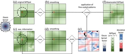
The impact of land use on ecosystems has reached critical levels, jeopardizing biosphere integrity. A key indicator that quantifies, monitors, and analyses such impacts is the Human Appropriation of Net Primary Production (HANPP). Assessing HANPP consists of a comparison of actual net primary production and potential vegetation properties—i.e., vegetation properties that would prevail in the absence of land use (i.e., the NPP of the potential vegetation; NPPpot). While technical advancements in remote sensing have led to global land cover data at high spatial resolution up to 30 arcsec (i.e., 1 km at the equator) and higher, spatial explicit global NPPpot, mainly provided by Dynamic Global Vegetation Models (DGVMs), are usually generated at 30 arcmin (i.e., 55 km at the equator). This spatial mismatch causes uncertainties in HANPP assessments. We here present a workable solution for downscaling NPPpot until global, high-resolution results, for example, from DGVMs, become feasible. This method uses a simple NPPpot model with readily available auxiliary information at higher spatial resolution to generate fine-scale patterns to downscale high-quality coarse scale NPPpot. It includes a smoothing procedure to reduce downscaling artifacts. We demonstrate this Smooth Auxiliary Data (SAD) downscaling by applying it to NPPpot results from the LPJ-GUESS DGVM model for the year 2010 to downscale from 30 arcmin to 30 arcsec resolution. This approach generates fine-scaled NPPpot patterns and aligns with alternative models for smaller geographic units while computational cost is acceptable.
期刊介绍:
JGR-Biogeosciences focuses on biogeosciences of the Earth system in the past, present, and future and the extension of this research to planetary studies. The emerging field of biogeosciences spans the intellectual interface between biology and the geosciences and attempts to understand the functions of the Earth system across multiple spatial and temporal scales. Studies in biogeosciences may use multiple lines of evidence drawn from diverse fields to gain a holistic understanding of terrestrial, freshwater, and marine ecosystems and extreme environments. Specific topics within the scope of the section include process-based theoretical, experimental, and field studies of biogeochemistry, biogeophysics, atmosphere-, land-, and ocean-ecosystem interactions, biomineralization, life in extreme environments, astrobiology, microbial processes, geomicrobiology, and evolutionary geobiology


 求助内容:
求助内容: 应助结果提醒方式:


