Lea Epple, Anne Bienert, Oliver Grothum, Jonas Lenz, Anette Eltner
{"title":"用粒子跟踪测速法揭示细尺度地表流动动力学:土壤侵蚀建模的新基准","authors":"Lea Epple, Anne Bienert, Oliver Grothum, Jonas Lenz, Anette Eltner","doi":"10.1002/esp.70127","DOIUrl":null,"url":null,"abstract":"<p>High-resolution measurements of soil surface flow velocity are critical for advancing the calibration and validation of physically based runoff and erosion models, yet such data remain scarce, particularly under field conditions. This study demonstrates the application and feasibility of particle tracking velocimetry (PTV) for capturing spatially distributed flow velocities during artificial rainfall simulations on agricultural plots. Combined with structure from motion (SfM) for topographic change detection, PTV enables detailed, non-invasive measurements of surface flow patterns at millimetre to centimetre scales. Two process-based models were applied and compared against these flow velocity observations. We further analysed the influence of digital elevation model (DEM) resolution on flow simulations, revealing that while average velocities remained relatively stable, spatial flow patterns and rill formation were strongly dependent on resolution. Model comparisons showed that dynamic surface updates better reflected observed flow patterns compared to a static approach. Measured flow velocities from PTV show slight variation from model outputs, due to scale and the nature of measurement. Our results position PTV as a powerful tool for future soil erosion research, enabling spatially resolved flow velocity estimation, improved validation of hydrodynamic processes, and more physically meaningful model parameterisation. This study provides a proof of concept for in-field PTV during rainfall simulations on small agricultural scales and for integrating high-resolution optical measurements into process-based runoff and erosion modelling workflows.</p>","PeriodicalId":11408,"journal":{"name":"Earth Surface Processes and Landforms","volume":"50 9","pages":""},"PeriodicalIF":2.7000,"publicationDate":"2025-07-22","publicationTypes":"Journal Article","fieldsOfStudy":null,"isOpenAccess":false,"openAccessPdf":"https://onlinelibrary.wiley.com/doi/epdf/10.1002/esp.70127","citationCount":"0","resultStr":"{\"title\":\"Uncovering fine-scale surface flow dynamics with particle tracking velocimetry: A new benchmark for soil erosion modelling\",\"authors\":\"Lea Epple, Anne Bienert, Oliver Grothum, Jonas Lenz, Anette Eltner\",\"doi\":\"10.1002/esp.70127\",\"DOIUrl\":null,\"url\":null,\"abstract\":\"<p>High-resolution measurements of soil surface flow velocity are critical for advancing the calibration and validation of physically based runoff and erosion models, yet such data remain scarce, particularly under field conditions. This study demonstrates the application and feasibility of particle tracking velocimetry (PTV) for capturing spatially distributed flow velocities during artificial rainfall simulations on agricultural plots. Combined with structure from motion (SfM) for topographic change detection, PTV enables detailed, non-invasive measurements of surface flow patterns at millimetre to centimetre scales. Two process-based models were applied and compared against these flow velocity observations. We further analysed the influence of digital elevation model (DEM) resolution on flow simulations, revealing that while average velocities remained relatively stable, spatial flow patterns and rill formation were strongly dependent on resolution. Model comparisons showed that dynamic surface updates better reflected observed flow patterns compared to a static approach. Measured flow velocities from PTV show slight variation from model outputs, due to scale and the nature of measurement. Our results position PTV as a powerful tool for future soil erosion research, enabling spatially resolved flow velocity estimation, improved validation of hydrodynamic processes, and more physically meaningful model parameterisation. This study provides a proof of concept for in-field PTV during rainfall simulations on small agricultural scales and for integrating high-resolution optical measurements into process-based runoff and erosion modelling workflows.</p>\",\"PeriodicalId\":11408,\"journal\":{\"name\":\"Earth Surface Processes and Landforms\",\"volume\":\"50 9\",\"pages\":\"\"},\"PeriodicalIF\":2.7000,\"publicationDate\":\"2025-07-22\",\"publicationTypes\":\"Journal Article\",\"fieldsOfStudy\":null,\"isOpenAccess\":false,\"openAccessPdf\":\"https://onlinelibrary.wiley.com/doi/epdf/10.1002/esp.70127\",\"citationCount\":\"0\",\"resultStr\":null,\"platform\":\"Semanticscholar\",\"paperid\":null,\"PeriodicalName\":\"Earth Surface Processes and Landforms\",\"FirstCategoryId\":\"89\",\"ListUrlMain\":\"https://onlinelibrary.wiley.com/doi/10.1002/esp.70127\",\"RegionNum\":3,\"RegionCategory\":\"地球科学\",\"ArticlePicture\":[],\"TitleCN\":null,\"AbstractTextCN\":null,\"PMCID\":null,\"EPubDate\":\"\",\"PubModel\":\"\",\"JCR\":\"Q2\",\"JCRName\":\"GEOGRAPHY, PHYSICAL\",\"Score\":null,\"Total\":0}","platform":"Semanticscholar","paperid":null,"PeriodicalName":"Earth Surface Processes and Landforms","FirstCategoryId":"89","ListUrlMain":"https://onlinelibrary.wiley.com/doi/10.1002/esp.70127","RegionNum":3,"RegionCategory":"地球科学","ArticlePicture":[],"TitleCN":null,"AbstractTextCN":null,"PMCID":null,"EPubDate":"","PubModel":"","JCR":"Q2","JCRName":"GEOGRAPHY, PHYSICAL","Score":null,"Total":0}
Uncovering fine-scale surface flow dynamics with particle tracking velocimetry: A new benchmark for soil erosion modelling
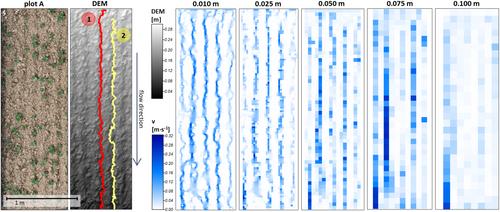
High-resolution measurements of soil surface flow velocity are critical for advancing the calibration and validation of physically based runoff and erosion models, yet such data remain scarce, particularly under field conditions. This study demonstrates the application and feasibility of particle tracking velocimetry (PTV) for capturing spatially distributed flow velocities during artificial rainfall simulations on agricultural plots. Combined with structure from motion (SfM) for topographic change detection, PTV enables detailed, non-invasive measurements of surface flow patterns at millimetre to centimetre scales. Two process-based models were applied and compared against these flow velocity observations. We further analysed the influence of digital elevation model (DEM) resolution on flow simulations, revealing that while average velocities remained relatively stable, spatial flow patterns and rill formation were strongly dependent on resolution. Model comparisons showed that dynamic surface updates better reflected observed flow patterns compared to a static approach. Measured flow velocities from PTV show slight variation from model outputs, due to scale and the nature of measurement. Our results position PTV as a powerful tool for future soil erosion research, enabling spatially resolved flow velocity estimation, improved validation of hydrodynamic processes, and more physically meaningful model parameterisation. This study provides a proof of concept for in-field PTV during rainfall simulations on small agricultural scales and for integrating high-resolution optical measurements into process-based runoff and erosion modelling workflows.
期刊介绍:
Earth Surface Processes and Landforms is an interdisciplinary international journal concerned with:
the interactions between surface processes and landforms and landscapes;
that lead to physical, chemical and biological changes; and which in turn create;
current landscapes and the geological record of past landscapes.
Its focus is core to both physical geographical and geological communities, and also the wider geosciences

 求助内容:
求助内容: 应助结果提醒方式:


