{"title":"基于HEC-HMS和HEC-RAS的水文图和网格降雨方法的城市洪水建模:以Culiacán河为例","authors":"Wenseslao Plata-Rocha , Evangelina Avila-Aceves , Sergio Alberto Monjardin-Armenta , Lidia Yadira Pérez-Aguilar , Jesús Gabriel Rangel-Peraza , Yedid Guadalupe Zambrano-Medina","doi":"10.1016/j.jsames.2025.105694","DOIUrl":null,"url":null,"abstract":"<div><div>Floods are devastating natural disasters, causing extensive economic losses and fatalities globally each year. In developing regions, flood modeling is often hindered by limited or inconsistent hydrometeorological data and historical records. Accurate floodplain modeling is essential for assessing flood risks and identifying vulnerable areas. Combining hydrological and hydraulic models with GIS has become a key approach for simulating and analyzing flood events, particularly in ungauged watersheds. Traditionally, flood simulation is a two-step process where a hydrological model provides flow input for a separate hydraulic model. Modern approaches, such as 'Rain-on-Grid', use a single and integrated step: rainfall is applied directly to a 2D hydraulic model's grid, which handles both runoff generation and the routing of water through the landscape, channels, and streets. This study models urban flooding by integrating a 'Rain-on-Grid' approach for surface runoff with a hydrograph, derived from SCS and Snyder methods, to simulate the river flow. Model performance was assessed against gauging station data. For the SCS model, results showed R<sup>2</sup> values of 0.927, NSE of 0.678, RMSE of 2.1, and PBIAS of 12.06 for the SCS model; the Snyder model presented an R<sup>2</sup> of 0.865, NSE of 0.75, RMSE equal to 2.3, and PBIAS of 23.84, indicating comparable performance. Hydraulic simulation was evaluated using the fraction of model performance (F<sup>(2)</sup>), with values of 0.7101 (SCS) and 0.7108 (Snyder). Hazard mapping identified rivers, irrigation canals, drains, levees, and road crossings as high-risk zones. Additionally, intermittent streams present significant flood hazards due to rapid onset and high flow velocities, posing threats to vehicles and residents.</div></div>","PeriodicalId":50047,"journal":{"name":"Journal of South American Earth Sciences","volume":"165 ","pages":"Article 105694"},"PeriodicalIF":1.5000,"publicationDate":"2025-07-20","publicationTypes":"Journal Article","fieldsOfStudy":null,"isOpenAccess":false,"openAccessPdf":"","citationCount":"0","resultStr":"{\"title\":\"Urban flood modeling using hydrograph and Rain-on-Grid approaches with HEC-HMS and HEC-RAS: A case study of the Culiacán River\",\"authors\":\"Wenseslao Plata-Rocha , Evangelina Avila-Aceves , Sergio Alberto Monjardin-Armenta , Lidia Yadira Pérez-Aguilar , Jesús Gabriel Rangel-Peraza , Yedid Guadalupe Zambrano-Medina\",\"doi\":\"10.1016/j.jsames.2025.105694\",\"DOIUrl\":null,\"url\":null,\"abstract\":\"<div><div>Floods are devastating natural disasters, causing extensive economic losses and fatalities globally each year. In developing regions, flood modeling is often hindered by limited or inconsistent hydrometeorological data and historical records. Accurate floodplain modeling is essential for assessing flood risks and identifying vulnerable areas. Combining hydrological and hydraulic models with GIS has become a key approach for simulating and analyzing flood events, particularly in ungauged watersheds. Traditionally, flood simulation is a two-step process where a hydrological model provides flow input for a separate hydraulic model. Modern approaches, such as 'Rain-on-Grid', use a single and integrated step: rainfall is applied directly to a 2D hydraulic model's grid, which handles both runoff generation and the routing of water through the landscape, channels, and streets. This study models urban flooding by integrating a 'Rain-on-Grid' approach for surface runoff with a hydrograph, derived from SCS and Snyder methods, to simulate the river flow. Model performance was assessed against gauging station data. For the SCS model, results showed R<sup>2</sup> values of 0.927, NSE of 0.678, RMSE of 2.1, and PBIAS of 12.06 for the SCS model; the Snyder model presented an R<sup>2</sup> of 0.865, NSE of 0.75, RMSE equal to 2.3, and PBIAS of 23.84, indicating comparable performance. Hydraulic simulation was evaluated using the fraction of model performance (F<sup>(2)</sup>), with values of 0.7101 (SCS) and 0.7108 (Snyder). Hazard mapping identified rivers, irrigation canals, drains, levees, and road crossings as high-risk zones. Additionally, intermittent streams present significant flood hazards due to rapid onset and high flow velocities, posing threats to vehicles and residents.</div></div>\",\"PeriodicalId\":50047,\"journal\":{\"name\":\"Journal of South American Earth Sciences\",\"volume\":\"165 \",\"pages\":\"Article 105694\"},\"PeriodicalIF\":1.5000,\"publicationDate\":\"2025-07-20\",\"publicationTypes\":\"Journal Article\",\"fieldsOfStudy\":null,\"isOpenAccess\":false,\"openAccessPdf\":\"\",\"citationCount\":\"0\",\"resultStr\":null,\"platform\":\"Semanticscholar\",\"paperid\":null,\"PeriodicalName\":\"Journal of South American Earth Sciences\",\"FirstCategoryId\":\"89\",\"ListUrlMain\":\"https://www.sciencedirect.com/science/article/pii/S0895981125003566\",\"RegionNum\":4,\"RegionCategory\":\"地球科学\",\"ArticlePicture\":[],\"TitleCN\":null,\"AbstractTextCN\":null,\"PMCID\":null,\"EPubDate\":\"\",\"PubModel\":\"\",\"JCR\":\"Q3\",\"JCRName\":\"GEOSCIENCES, MULTIDISCIPLINARY\",\"Score\":null,\"Total\":0}","platform":"Semanticscholar","paperid":null,"PeriodicalName":"Journal of South American Earth Sciences","FirstCategoryId":"89","ListUrlMain":"https://www.sciencedirect.com/science/article/pii/S0895981125003566","RegionNum":4,"RegionCategory":"地球科学","ArticlePicture":[],"TitleCN":null,"AbstractTextCN":null,"PMCID":null,"EPubDate":"","PubModel":"","JCR":"Q3","JCRName":"GEOSCIENCES, MULTIDISCIPLINARY","Score":null,"Total":0}
Urban flood modeling using hydrograph and Rain-on-Grid approaches with HEC-HMS and HEC-RAS: A case study of the Culiacán River
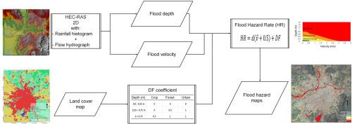
Floods are devastating natural disasters, causing extensive economic losses and fatalities globally each year. In developing regions, flood modeling is often hindered by limited or inconsistent hydrometeorological data and historical records. Accurate floodplain modeling is essential for assessing flood risks and identifying vulnerable areas. Combining hydrological and hydraulic models with GIS has become a key approach for simulating and analyzing flood events, particularly in ungauged watersheds. Traditionally, flood simulation is a two-step process where a hydrological model provides flow input for a separate hydraulic model. Modern approaches, such as 'Rain-on-Grid', use a single and integrated step: rainfall is applied directly to a 2D hydraulic model's grid, which handles both runoff generation and the routing of water through the landscape, channels, and streets. This study models urban flooding by integrating a 'Rain-on-Grid' approach for surface runoff with a hydrograph, derived from SCS and Snyder methods, to simulate the river flow. Model performance was assessed against gauging station data. For the SCS model, results showed R2 values of 0.927, NSE of 0.678, RMSE of 2.1, and PBIAS of 12.06 for the SCS model; the Snyder model presented an R2 of 0.865, NSE of 0.75, RMSE equal to 2.3, and PBIAS of 23.84, indicating comparable performance. Hydraulic simulation was evaluated using the fraction of model performance (F(2)), with values of 0.7101 (SCS) and 0.7108 (Snyder). Hazard mapping identified rivers, irrigation canals, drains, levees, and road crossings as high-risk zones. Additionally, intermittent streams present significant flood hazards due to rapid onset and high flow velocities, posing threats to vehicles and residents.
期刊介绍:
Papers must have a regional appeal and should present work of more than local significance. Research papers dealing with the regional geology of South American cratons and mobile belts, within the following research fields:
-Economic geology, metallogenesis and hydrocarbon genesis and reservoirs.
-Geophysics, geochemistry, volcanology, igneous and metamorphic petrology.
-Tectonics, neo- and seismotectonics and geodynamic modeling.
-Geomorphology, geological hazards, environmental geology, climate change in America and Antarctica, and soil research.
-Stratigraphy, sedimentology, structure and basin evolution.
-Paleontology, paleoecology, paleoclimatology and Quaternary geology.
New developments in already established regional projects and new initiatives dealing with the geology of the continent will be summarized and presented on a regular basis. Short notes, discussions, book reviews and conference and workshop reports will also be included when relevant.