空气介导的生态系统服务流模拟与时空动态分析——以关中平原城市群为例
IF 7
2区 环境科学与生态学
Q1 ENVIRONMENTAL SCIENCES
引用次数: 0
摘要
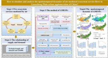
从时空流动的角度分析生态系统服务的供需关系,对于深入了解生态系统服务的流动过程,保障区域生态安全,优化资源配置,促进可持续发展具有重要意义。然而,以往的研究主要集中在具有特定物理通道的有形物质(如水、土壤、动物等)介导的生态系统服务流,对无形载体(特别是空气)介导的生态系统服务流的研究较少,且缺乏方法。为此,以关中平原城市群为例,提出了空气介导生态系统服务流的流量分析框架,量化了5种生态系统服务流的供需关系,模拟了空气介导生态系统服务流的流场,确定了其流向、流量和路径,并对其时空动态进行了分析。结果表明,GPUA中ESs存在显著的空间不匹配。高富余区主要分布在森林覆盖的山区,高亏缺区主要集中在汾渭平原的耕地和黄土高原部分地区,以城市及周边地区为主。2000-2020年期间,上述ESs的流量表现出相似的年际变化最小的特征。总体而言,确定了五个主要的流动路径,从GPUA的东北部和东南部向西部、西北部和西南部延伸。虽然服务的总供给大于总需求,但大部分剩余服务都流出了研究区域,需求无法得到满足。amesf主要由当地盛行风驱动,而不是供需关系。该框架对于揭示空气介导的ESs的空间流动特征和动态过程具有重要意义,并适用于其他地区。这也为区域大气污染防治和绿色基础设施建设提供了一种评价方法。本文章由计算机程序翻译,如有差异,请以英文原文为准。
Simulation and spatiotemporal dynamic analysis of air-mediated ecosystem service flows: A case study of Guanzhong Plain urban agglomeration
Analyzing the relationship between supply and demand of ecosystem services (ESs) from a spatiotemporal flow perspective is crucial for in-depth insight into flow process of ESs, and ensuring regional ecological security, optimizing resource allocation, and promoting sustainable development. However, previous studies have primarily focused on the flow of ecosystem service mediated by tangible substances (e.g., water, soil, animals etc.) with specific physical channels, the flow of ecosystem services mediated by intangible carriers (especially by air) remain rare and are lack of methods. Thus, taking the Guanzhong Plain urban agglomeration (GPUA) as a case, we proposed a flow analysis framework for air-mediated ecosystem service flows (AMESFs), quantified the supply–demand relationship of five ESs, simulated the air-mediated ESs flow field, determined the flow direction, volumes and paths, and analyzed their spatiotemporal dynamics. The results showed significant spatial mismatches of ESs in GPUA. High surplus areas were primarily distributed in forest-covered mountainous regions, while high deficit areas were concentrated in the cultivated regions of the Fenwei Plain and parts of the Loess Plateau, particularly in urban and adjacent areas. The flows of above ESs exhibited a similar pattern with minimal interannual variation during 2000–2020. Overall, five primary flow pathways were identified, extending from the northeastern and southeastern parts of GPUA toward the west, northwest, and southwest. Although the total supply of services was greater than the total demand, most of surplus service flowed out of the study area and the demand was not satisfied locally. The AMESFs were predominantly driven by the local prevailing wind rather than the supply–demand relationships. The framework is crucial for revealing the spatial flow characteristics and dynamic processes of ESs mediated by air and applicable to other regions. That also provides an assessment method for regional air pollution prevention and control, and green infrastructure development.
求助全文
通过发布文献求助,成功后即可免费获取论文全文。
去求助
来源期刊

Ecological Indicators
环境科学-环境科学
CiteScore
11.80
自引率
8.70%
发文量
1163
审稿时长
78 days
期刊介绍:
The ultimate aim of Ecological Indicators is to integrate the monitoring and assessment of ecological and environmental indicators with management practices. The journal provides a forum for the discussion of the applied scientific development and review of traditional indicator approaches as well as for theoretical, modelling and quantitative applications such as index development. Research into the following areas will be published.
• All aspects of ecological and environmental indicators and indices.
• New indicators, and new approaches and methods for indicator development, testing and use.
• Development and modelling of indices, e.g. application of indicator suites across multiple scales and resources.
• Analysis and research of resource, system- and scale-specific indicators.
• Methods for integration of social and other valuation metrics for the production of scientifically rigorous and politically-relevant assessments using indicator-based monitoring and assessment programs.
• How research indicators can be transformed into direct application for management purposes.
• Broader assessment objectives and methods, e.g. biodiversity, biological integrity, and sustainability, through the use of indicators.
• Resource-specific indicators such as landscape, agroecosystems, forests, wetlands, etc.
 求助内容:
求助内容: 应助结果提醒方式:


