Jun Shang, Mingyang Wang, Xin Wang, Mengyao Yang, Yifan Wu, Wangze Du
{"title":"基于SBAS-INSAR技术的山区地表三维变形场监测及影响因素分析(天津)","authors":"Jun Shang, Mingyang Wang, Xin Wang, Mengyao Yang, Yifan Wu, Wangze Du","doi":"10.1038/s41598-025-10894-2","DOIUrl":null,"url":null,"abstract":"<p><p>Synthetic aperture radar interferometry (InSAR) technology has emerged as a critical methodology for disaster reduction and prevention, offering unprecedented all-weather operational capabilities and extensive spatial coverage that effectively address the limitations of traditional detection methods. Despite the inherent challenges of temporal and spatial coherence in conventional time-series InSAR approaches, the small baseline subset InSAR (SBAS-InSAR) technique presents a sophisticated solution by significantly mitigating coherence-related uncertainties and enhancing measurement precision. While existing research predominantly focuses on urban environments, this study uniquely addresses the research gap in mountainous terrain deformation monitoring by utilizing Sentinel-1A and 1B single-look complex (SLC) data from ascending and descending orbits between January 2018 and May 2022. The comprehensive analysis of land subsidence in northern Tianjin's mountainous region revealed multi-directional surface deformation characteristics, with validation against GNSS Kriging interpolation data demonstrating root mean square errors of 5.74 mm and 5.09 mm in vertical and east-west directions, respectively. The investigation exposed predominantly horizontal deformation influenced by large-scale engineering activities, topographic conditions, and precipitation patterns, with notable findings including a maximum north-south deformation of 54.62 mm in the Maojiayu landslide area and vertical cumulative deformations of 21.10 mm and - 10.31 mm in Maojiayu and Taoosi landslide areas. These results substantiate the efficacy of InSAR technology in monitoring surface deformation in mountainous regions, offering critical insights for regional geological disaster prevention and mitigation strategies.</p>","PeriodicalId":21811,"journal":{"name":"Scientific Reports","volume":"15 1","pages":"25702"},"PeriodicalIF":3.9000,"publicationDate":"2025-07-16","publicationTypes":"Journal Article","fieldsOfStudy":null,"isOpenAccess":false,"openAccessPdf":"https://www.ncbi.nlm.nih.gov/pmc/articles/PMC12267393/pdf/","citationCount":"0","resultStr":"{\"title\":\"Three-dimensional surface deformation field monitoring and influencing factors analysis in mountainous areas based on SBAS-INSAR technology (Tianjin, China).\",\"authors\":\"Jun Shang, Mingyang Wang, Xin Wang, Mengyao Yang, Yifan Wu, Wangze Du\",\"doi\":\"10.1038/s41598-025-10894-2\",\"DOIUrl\":null,\"url\":null,\"abstract\":\"<p><p>Synthetic aperture radar interferometry (InSAR) technology has emerged as a critical methodology for disaster reduction and prevention, offering unprecedented all-weather operational capabilities and extensive spatial coverage that effectively address the limitations of traditional detection methods. Despite the inherent challenges of temporal and spatial coherence in conventional time-series InSAR approaches, the small baseline subset InSAR (SBAS-InSAR) technique presents a sophisticated solution by significantly mitigating coherence-related uncertainties and enhancing measurement precision. While existing research predominantly focuses on urban environments, this study uniquely addresses the research gap in mountainous terrain deformation monitoring by utilizing Sentinel-1A and 1B single-look complex (SLC) data from ascending and descending orbits between January 2018 and May 2022. The comprehensive analysis of land subsidence in northern Tianjin's mountainous region revealed multi-directional surface deformation characteristics, with validation against GNSS Kriging interpolation data demonstrating root mean square errors of 5.74 mm and 5.09 mm in vertical and east-west directions, respectively. The investigation exposed predominantly horizontal deformation influenced by large-scale engineering activities, topographic conditions, and precipitation patterns, with notable findings including a maximum north-south deformation of 54.62 mm in the Maojiayu landslide area and vertical cumulative deformations of 21.10 mm and - 10.31 mm in Maojiayu and Taoosi landslide areas. These results substantiate the efficacy of InSAR technology in monitoring surface deformation in mountainous regions, offering critical insights for regional geological disaster prevention and mitigation strategies.</p>\",\"PeriodicalId\":21811,\"journal\":{\"name\":\"Scientific Reports\",\"volume\":\"15 1\",\"pages\":\"25702\"},\"PeriodicalIF\":3.9000,\"publicationDate\":\"2025-07-16\",\"publicationTypes\":\"Journal Article\",\"fieldsOfStudy\":null,\"isOpenAccess\":false,\"openAccessPdf\":\"https://www.ncbi.nlm.nih.gov/pmc/articles/PMC12267393/pdf/\",\"citationCount\":\"0\",\"resultStr\":null,\"platform\":\"Semanticscholar\",\"paperid\":null,\"PeriodicalName\":\"Scientific Reports\",\"FirstCategoryId\":\"103\",\"ListUrlMain\":\"https://doi.org/10.1038/s41598-025-10894-2\",\"RegionNum\":2,\"RegionCategory\":\"综合性期刊\",\"ArticlePicture\":[],\"TitleCN\":null,\"AbstractTextCN\":null,\"PMCID\":null,\"EPubDate\":\"\",\"PubModel\":\"\",\"JCR\":\"Q1\",\"JCRName\":\"MULTIDISCIPLINARY SCIENCES\",\"Score\":null,\"Total\":0}","platform":"Semanticscholar","paperid":null,"PeriodicalName":"Scientific Reports","FirstCategoryId":"103","ListUrlMain":"https://doi.org/10.1038/s41598-025-10894-2","RegionNum":2,"RegionCategory":"综合性期刊","ArticlePicture":[],"TitleCN":null,"AbstractTextCN":null,"PMCID":null,"EPubDate":"","PubModel":"","JCR":"Q1","JCRName":"MULTIDISCIPLINARY SCIENCES","Score":null,"Total":0}
Three-dimensional surface deformation field monitoring and influencing factors analysis in mountainous areas based on SBAS-INSAR technology (Tianjin, China).
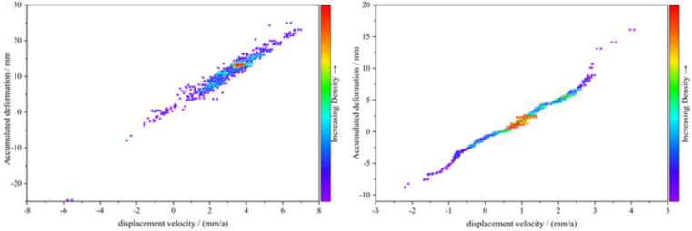
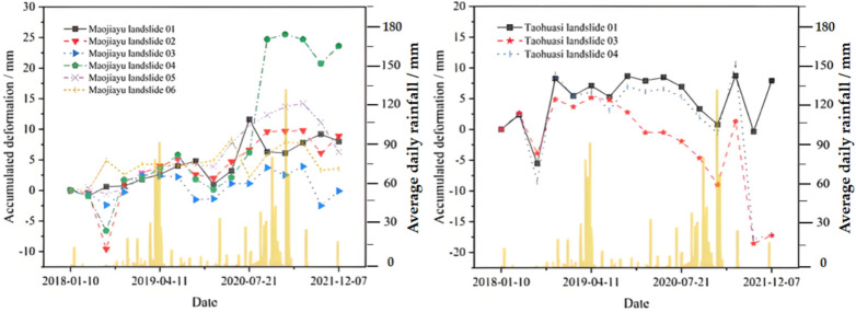
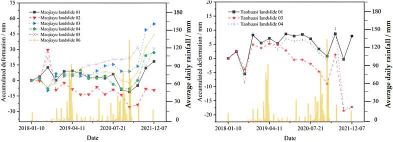
Synthetic aperture radar interferometry (InSAR) technology has emerged as a critical methodology for disaster reduction and prevention, offering unprecedented all-weather operational capabilities and extensive spatial coverage that effectively address the limitations of traditional detection methods. Despite the inherent challenges of temporal and spatial coherence in conventional time-series InSAR approaches, the small baseline subset InSAR (SBAS-InSAR) technique presents a sophisticated solution by significantly mitigating coherence-related uncertainties and enhancing measurement precision. While existing research predominantly focuses on urban environments, this study uniquely addresses the research gap in mountainous terrain deformation monitoring by utilizing Sentinel-1A and 1B single-look complex (SLC) data from ascending and descending orbits between January 2018 and May 2022. The comprehensive analysis of land subsidence in northern Tianjin's mountainous region revealed multi-directional surface deformation characteristics, with validation against GNSS Kriging interpolation data demonstrating root mean square errors of 5.74 mm and 5.09 mm in vertical and east-west directions, respectively. The investigation exposed predominantly horizontal deformation influenced by large-scale engineering activities, topographic conditions, and precipitation patterns, with notable findings including a maximum north-south deformation of 54.62 mm in the Maojiayu landslide area and vertical cumulative deformations of 21.10 mm and - 10.31 mm in Maojiayu and Taoosi landslide areas. These results substantiate the efficacy of InSAR technology in monitoring surface deformation in mountainous regions, offering critical insights for regional geological disaster prevention and mitigation strategies.
期刊介绍:
We publish original research from all areas of the natural sciences, psychology, medicine and engineering. You can learn more about what we publish by browsing our specific scientific subject areas below or explore Scientific Reports by browsing all articles and collections.
Scientific Reports has a 2-year impact factor: 4.380 (2021), and is the 6th most-cited journal in the world, with more than 540,000 citations in 2020 (Clarivate Analytics, 2021).
•Engineering
Engineering covers all aspects of engineering, technology, and applied science. It plays a crucial role in the development of technologies to address some of the world''s biggest challenges, helping to save lives and improve the way we live.
•Physical sciences
Physical sciences are those academic disciplines that aim to uncover the underlying laws of nature — often written in the language of mathematics. It is a collective term for areas of study including astronomy, chemistry, materials science and physics.
•Earth and environmental sciences
Earth and environmental sciences cover all aspects of Earth and planetary science and broadly encompass solid Earth processes, surface and atmospheric dynamics, Earth system history, climate and climate change, marine and freshwater systems, and ecology. It also considers the interactions between humans and these systems.
•Biological sciences
Biological sciences encompass all the divisions of natural sciences examining various aspects of vital processes. The concept includes anatomy, physiology, cell biology, biochemistry and biophysics, and covers all organisms from microorganisms, animals to plants.
•Health sciences
The health sciences study health, disease and healthcare. This field of study aims to develop knowledge, interventions and technology for use in healthcare to improve the treatment of patients.

 求助内容:
求助内容: 应助结果提醒方式:


