{"title":"探索基于sentinel -2的光谱变异性以增强德国草原多样性评估","authors":"Antonia Ludwig, Hannes Feilhauer, Daniel Doktor","doi":"10.1111/avsc.70030","DOIUrl":null,"url":null,"abstract":"<div>\n \n \n <section>\n \n <h3> Questions</h3>\n \n <p>Can remote sensing data support the assessment of High Nature Value (HNV) conservation categories in the German HNV monitoring scheme? Specifically, does spectral pixel-to-pixel variability improve classification accuracy of HNV categories based on Sentinel-2 data?</p>\n </section>\n \n <section>\n \n <h3> Location</h3>\n \n <p>Germany.</p>\n </section>\n \n <section>\n \n <h3> Methods</h3>\n \n <p>We used multispectral Sentinel-2 imagery (10 m resolution) from 5 years (2017–2021) to classify HNV categories. Random Forest models were trained using different predictor combinations, including spectral data, phenology, and geographical location. We applied various cross-validation strategies to assess classification accuracy.</p>\n </section>\n \n <section>\n \n <h3> Results</h3>\n \n <p>Classification accuracy was generally low (≈44%) when using target-oriented cross-validation, suggesting limited agreement between predictions and actual HNV categories. Spectral variability alone did not clearly correspond to HNV diversity categories. Instead, geographic location and management emerged as the most important predictors for classification.</p>\n </section>\n \n <section>\n \n <h3> Conclusions</h3>\n \n <p>Our findings highlight the challenges of linking ecological field data with remote sensing information for biodiversity assessments. Improved integration of ecological and remote sensing data is necessary to enhance the effectiveness of biodiversity monitoring schemes.</p>\n </section>\n </div>","PeriodicalId":55494,"journal":{"name":"Applied Vegetation Science","volume":"28 3","pages":""},"PeriodicalIF":2.6000,"publicationDate":"2025-07-18","publicationTypes":"Journal Article","fieldsOfStudy":null,"isOpenAccess":false,"openAccessPdf":"https://onlinelibrary.wiley.com/doi/epdf/10.1111/avsc.70030","citationCount":"0","resultStr":"{\"title\":\"Exploring Sentinel-2-Based Spectral Variability for Enhancing Grassland Diversity Assessments Across Germany\",\"authors\":\"Antonia Ludwig, Hannes Feilhauer, Daniel Doktor\",\"doi\":\"10.1111/avsc.70030\",\"DOIUrl\":null,\"url\":null,\"abstract\":\"<div>\\n \\n \\n <section>\\n \\n <h3> Questions</h3>\\n \\n <p>Can remote sensing data support the assessment of High Nature Value (HNV) conservation categories in the German HNV monitoring scheme? Specifically, does spectral pixel-to-pixel variability improve classification accuracy of HNV categories based on Sentinel-2 data?</p>\\n </section>\\n \\n <section>\\n \\n <h3> Location</h3>\\n \\n <p>Germany.</p>\\n </section>\\n \\n <section>\\n \\n <h3> Methods</h3>\\n \\n <p>We used multispectral Sentinel-2 imagery (10 m resolution) from 5 years (2017–2021) to classify HNV categories. Random Forest models were trained using different predictor combinations, including spectral data, phenology, and geographical location. We applied various cross-validation strategies to assess classification accuracy.</p>\\n </section>\\n \\n <section>\\n \\n <h3> Results</h3>\\n \\n <p>Classification accuracy was generally low (≈44%) when using target-oriented cross-validation, suggesting limited agreement between predictions and actual HNV categories. Spectral variability alone did not clearly correspond to HNV diversity categories. Instead, geographic location and management emerged as the most important predictors for classification.</p>\\n </section>\\n \\n <section>\\n \\n <h3> Conclusions</h3>\\n \\n <p>Our findings highlight the challenges of linking ecological field data with remote sensing information for biodiversity assessments. Improved integration of ecological and remote sensing data is necessary to enhance the effectiveness of biodiversity monitoring schemes.</p>\\n </section>\\n </div>\",\"PeriodicalId\":55494,\"journal\":{\"name\":\"Applied Vegetation Science\",\"volume\":\"28 3\",\"pages\":\"\"},\"PeriodicalIF\":2.6000,\"publicationDate\":\"2025-07-18\",\"publicationTypes\":\"Journal Article\",\"fieldsOfStudy\":null,\"isOpenAccess\":false,\"openAccessPdf\":\"https://onlinelibrary.wiley.com/doi/epdf/10.1111/avsc.70030\",\"citationCount\":\"0\",\"resultStr\":null,\"platform\":\"Semanticscholar\",\"paperid\":null,\"PeriodicalName\":\"Applied Vegetation Science\",\"FirstCategoryId\":\"93\",\"ListUrlMain\":\"https://onlinelibrary.wiley.com/doi/10.1111/avsc.70030\",\"RegionNum\":3,\"RegionCategory\":\"环境科学与生态学\",\"ArticlePicture\":[],\"TitleCN\":null,\"AbstractTextCN\":null,\"PMCID\":null,\"EPubDate\":\"\",\"PubModel\":\"\",\"JCR\":\"Q3\",\"JCRName\":\"ECOLOGY\",\"Score\":null,\"Total\":0}","platform":"Semanticscholar","paperid":null,"PeriodicalName":"Applied Vegetation Science","FirstCategoryId":"93","ListUrlMain":"https://onlinelibrary.wiley.com/doi/10.1111/avsc.70030","RegionNum":3,"RegionCategory":"环境科学与生态学","ArticlePicture":[],"TitleCN":null,"AbstractTextCN":null,"PMCID":null,"EPubDate":"","PubModel":"","JCR":"Q3","JCRName":"ECOLOGY","Score":null,"Total":0}
Exploring Sentinel-2-Based Spectral Variability for Enhancing Grassland Diversity Assessments Across Germany
Questions
Can remote sensing data support the assessment of High Nature Value (HNV) conservation categories in the German HNV monitoring scheme? Specifically, does spectral pixel-to-pixel variability improve classification accuracy of HNV categories based on Sentinel-2 data?
Location
Germany.
Methods
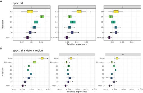
We used multispectral Sentinel-2 imagery (10 m resolution) from 5 years (2017–2021) to classify HNV categories. Random Forest models were trained using different predictor combinations, including spectral data, phenology, and geographical location. We applied various cross-validation strategies to assess classification accuracy.
Results
Classification accuracy was generally low (≈44%) when using target-oriented cross-validation, suggesting limited agreement between predictions and actual HNV categories. Spectral variability alone did not clearly correspond to HNV diversity categories. Instead, geographic location and management emerged as the most important predictors for classification.
Conclusions
Our findings highlight the challenges of linking ecological field data with remote sensing information for biodiversity assessments. Improved integration of ecological and remote sensing data is necessary to enhance the effectiveness of biodiversity monitoring schemes.
期刊介绍:
Applied Vegetation Science focuses on community-level topics relevant to human interaction with vegetation, including global change, nature conservation, nature management, restoration of plant communities and of natural habitats, and the planning of semi-natural and urban landscapes. Vegetation survey, modelling and remote-sensing applications are welcome. Papers on vegetation science which do not fit to this scope (do not have an applied aspect and are not vegetation survey) should be directed to our associate journal, the Journal of Vegetation Science. Both journals publish papers on the ecology of a single species only if it plays a key role in structuring plant communities.
 求助内容:
求助内容: 应助结果提醒方式:


