Guangchun Liu, Huan He, Yun Gao, Guangbao Zhang, Tianyu Cao
{"title":"基于生成对抗网络和U-Net的地图地理信息道路提取方法。","authors":"Guangchun Liu, Huan He, Yun Gao, Guangbao Zhang, Tianyu Cao","doi":"10.1038/s41598-025-10979-y","DOIUrl":null,"url":null,"abstract":"<p><p>In today's rapidly developing remote sensing technology, accurately extracting geographic information from maps is crucial for many key areas such as urban planning, environmental monitoring, and traffic management. However, due to the complexity and variability of remote sensing images, effectively extracting road information from multi-scale geographic images remains a technical challenge. Therefore, the study innovatively proposes a fusion model for panchromatic and multi-spectral images and a fusion map geographic information extraction model from the perspectives of image fusion and road segmentation. Structural similarity and spatial correlation coefficients are crucial for assessing the effectiveness of model image fusion. The experimental results show that in the panchromatic and multispectral remote sensing image datasets, the structural similarity of the model reached 0.023, which was very close to the target value of 0, indicating that the model had excellent image fusion ability. Meanwhile, the spatial correlation coefficient value was also as high as 0.99, close to the target value of 1, further confirming the efficiency of the model in image fusion. Compared with other methods, the designed method had significant advantages in maintaining the continuity of road structure, which could more accurately identify and reproduce the continuity of roads and reduce errors in the extraction process. In summary, the research results are of great significance to improve the accuracy and efficiency of remote sensing image analysis, which not only can provide strong technical support for the application in the above related fields, but also can contribute to the further development and application of remote sensing technology in geographic information extraction.</p>","PeriodicalId":21811,"journal":{"name":"Scientific Reports","volume":"15 1","pages":"25321"},"PeriodicalIF":3.9000,"publicationDate":"2025-07-13","publicationTypes":"Journal Article","fieldsOfStudy":null,"isOpenAccess":false,"openAccessPdf":"https://www.ncbi.nlm.nih.gov/pmc/articles/PMC12256586/pdf/","citationCount":"0","resultStr":"{\"title\":\"Map geographic information road extraction method based on generative adversarial network and U-Net.\",\"authors\":\"Guangchun Liu, Huan He, Yun Gao, Guangbao Zhang, Tianyu Cao\",\"doi\":\"10.1038/s41598-025-10979-y\",\"DOIUrl\":null,\"url\":null,\"abstract\":\"<p><p>In today's rapidly developing remote sensing technology, accurately extracting geographic information from maps is crucial for many key areas such as urban planning, environmental monitoring, and traffic management. However, due to the complexity and variability of remote sensing images, effectively extracting road information from multi-scale geographic images remains a technical challenge. Therefore, the study innovatively proposes a fusion model for panchromatic and multi-spectral images and a fusion map geographic information extraction model from the perspectives of image fusion and road segmentation. Structural similarity and spatial correlation coefficients are crucial for assessing the effectiveness of model image fusion. The experimental results show that in the panchromatic and multispectral remote sensing image datasets, the structural similarity of the model reached 0.023, which was very close to the target value of 0, indicating that the model had excellent image fusion ability. Meanwhile, the spatial correlation coefficient value was also as high as 0.99, close to the target value of 1, further confirming the efficiency of the model in image fusion. Compared with other methods, the designed method had significant advantages in maintaining the continuity of road structure, which could more accurately identify and reproduce the continuity of roads and reduce errors in the extraction process. In summary, the research results are of great significance to improve the accuracy and efficiency of remote sensing image analysis, which not only can provide strong technical support for the application in the above related fields, but also can contribute to the further development and application of remote sensing technology in geographic information extraction.</p>\",\"PeriodicalId\":21811,\"journal\":{\"name\":\"Scientific Reports\",\"volume\":\"15 1\",\"pages\":\"25321\"},\"PeriodicalIF\":3.9000,\"publicationDate\":\"2025-07-13\",\"publicationTypes\":\"Journal Article\",\"fieldsOfStudy\":null,\"isOpenAccess\":false,\"openAccessPdf\":\"https://www.ncbi.nlm.nih.gov/pmc/articles/PMC12256586/pdf/\",\"citationCount\":\"0\",\"resultStr\":null,\"platform\":\"Semanticscholar\",\"paperid\":null,\"PeriodicalName\":\"Scientific Reports\",\"FirstCategoryId\":\"103\",\"ListUrlMain\":\"https://doi.org/10.1038/s41598-025-10979-y\",\"RegionNum\":2,\"RegionCategory\":\"综合性期刊\",\"ArticlePicture\":[],\"TitleCN\":null,\"AbstractTextCN\":null,\"PMCID\":null,\"EPubDate\":\"\",\"PubModel\":\"\",\"JCR\":\"Q1\",\"JCRName\":\"MULTIDISCIPLINARY SCIENCES\",\"Score\":null,\"Total\":0}","platform":"Semanticscholar","paperid":null,"PeriodicalName":"Scientific Reports","FirstCategoryId":"103","ListUrlMain":"https://doi.org/10.1038/s41598-025-10979-y","RegionNum":2,"RegionCategory":"综合性期刊","ArticlePicture":[],"TitleCN":null,"AbstractTextCN":null,"PMCID":null,"EPubDate":"","PubModel":"","JCR":"Q1","JCRName":"MULTIDISCIPLINARY SCIENCES","Score":null,"Total":0}
Map geographic information road extraction method based on generative adversarial network and U-Net.
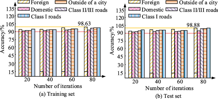
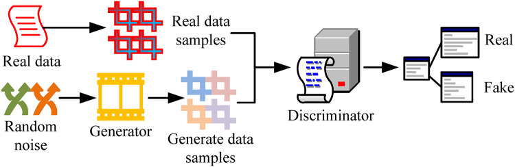
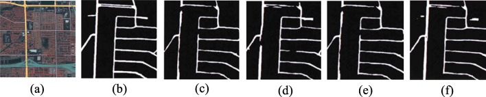
In today's rapidly developing remote sensing technology, accurately extracting geographic information from maps is crucial for many key areas such as urban planning, environmental monitoring, and traffic management. However, due to the complexity and variability of remote sensing images, effectively extracting road information from multi-scale geographic images remains a technical challenge. Therefore, the study innovatively proposes a fusion model for panchromatic and multi-spectral images and a fusion map geographic information extraction model from the perspectives of image fusion and road segmentation. Structural similarity and spatial correlation coefficients are crucial for assessing the effectiveness of model image fusion. The experimental results show that in the panchromatic and multispectral remote sensing image datasets, the structural similarity of the model reached 0.023, which was very close to the target value of 0, indicating that the model had excellent image fusion ability. Meanwhile, the spatial correlation coefficient value was also as high as 0.99, close to the target value of 1, further confirming the efficiency of the model in image fusion. Compared with other methods, the designed method had significant advantages in maintaining the continuity of road structure, which could more accurately identify and reproduce the continuity of roads and reduce errors in the extraction process. In summary, the research results are of great significance to improve the accuracy and efficiency of remote sensing image analysis, which not only can provide strong technical support for the application in the above related fields, but also can contribute to the further development and application of remote sensing technology in geographic information extraction.
期刊介绍:
We publish original research from all areas of the natural sciences, psychology, medicine and engineering. You can learn more about what we publish by browsing our specific scientific subject areas below or explore Scientific Reports by browsing all articles and collections.
Scientific Reports has a 2-year impact factor: 4.380 (2021), and is the 6th most-cited journal in the world, with more than 540,000 citations in 2020 (Clarivate Analytics, 2021).
•Engineering
Engineering covers all aspects of engineering, technology, and applied science. It plays a crucial role in the development of technologies to address some of the world''s biggest challenges, helping to save lives and improve the way we live.
•Physical sciences
Physical sciences are those academic disciplines that aim to uncover the underlying laws of nature — often written in the language of mathematics. It is a collective term for areas of study including astronomy, chemistry, materials science and physics.
•Earth and environmental sciences
Earth and environmental sciences cover all aspects of Earth and planetary science and broadly encompass solid Earth processes, surface and atmospheric dynamics, Earth system history, climate and climate change, marine and freshwater systems, and ecology. It also considers the interactions between humans and these systems.
•Biological sciences
Biological sciences encompass all the divisions of natural sciences examining various aspects of vital processes. The concept includes anatomy, physiology, cell biology, biochemistry and biophysics, and covers all organisms from microorganisms, animals to plants.
•Health sciences
The health sciences study health, disease and healthcare. This field of study aims to develop knowledge, interventions and technology for use in healthcare to improve the treatment of patients.

 求助内容:
求助内容: 应助结果提醒方式:


