G. J. Verkaik, M. G. K. Eckert, S. L. Wilkinson, P. A. Moore, J. M. Waddington
{"title":"在北方森林泥炭地排水后,燃料负荷和泥炭阴燃碳损失增加","authors":"G. J. Verkaik, M. G. K. Eckert, S. L. Wilkinson, P. A. Moore, J. M. Waddington","doi":"10.1029/2024JG008674","DOIUrl":null,"url":null,"abstract":"<p>We aimed to assess how peatland drainage altered the spatiotemporal variability in forest cover, aboveground biomass, and tree productivity and how these changes related to the spatial variability in peat burn severity. We studied a black spruce and birch dominated boreal peatland in Parkland County, Alberta, Canada, which was drained in 1987 and burned in 2021. Using remote sensing techniques (historical imagery and LiDAR), we determined that forest cover increased by 180% following drainage and aboveground tree biomass decreased from 26.1 kg m<sup>−2</sup> adjacent to the nearest drainage ditch to 2.8 kg m<sup>−2</sup> 95 m away from the nearest ditch. Field surveys and a LiDAR-based analysis were conducted to measure the spatial variability in peat burn severity. Drained peatland margins experienced the greatest peat burn severity with a mean depth of burn of 26.9 ± 12.6 cm (18.2 ± 10.1 kg C m<sup>−2</sup>) compared to natural middles at 15.3 ± 6.2 cm (3.9 ± 2.1 kg C m<sup>−2</sup>), where peat burn severity increased with proximity to ditches and greater aboveground biomass. We present a conceptual model outlining the increases in aboveground and peat fuel loads following drainage and suggest that the area around a ditch that is impacted by drainage, which is commonly assumed to be 30 m, likely increases through time in forested peatlands due to the afforestation feedback. Drained peatlands represent a severe fire risk for communities and fire management agencies. Peatland restoration should be integrated into fuel management strategies to reduce the risk that drained peatlands pose.</p>","PeriodicalId":16003,"journal":{"name":"Journal of Geophysical Research: Biogeosciences","volume":"130 7","pages":""},"PeriodicalIF":3.5000,"publicationDate":"2025-07-12","publicationTypes":"Journal Article","fieldsOfStudy":null,"isOpenAccess":false,"openAccessPdf":"https://onlinelibrary.wiley.com/doi/epdf/10.1029/2024JG008674","citationCount":"0","resultStr":"{\"title\":\"Fuel Loads and Peat Smoldering Carbon Loss Increase Following Drainage in a Forested Boreal Peatland\",\"authors\":\"G. J. Verkaik, M. G. K. Eckert, S. L. Wilkinson, P. A. Moore, J. M. Waddington\",\"doi\":\"10.1029/2024JG008674\",\"DOIUrl\":null,\"url\":null,\"abstract\":\"<p>We aimed to assess how peatland drainage altered the spatiotemporal variability in forest cover, aboveground biomass, and tree productivity and how these changes related to the spatial variability in peat burn severity. We studied a black spruce and birch dominated boreal peatland in Parkland County, Alberta, Canada, which was drained in 1987 and burned in 2021. Using remote sensing techniques (historical imagery and LiDAR), we determined that forest cover increased by 180% following drainage and aboveground tree biomass decreased from 26.1 kg m<sup>−2</sup> adjacent to the nearest drainage ditch to 2.8 kg m<sup>−2</sup> 95 m away from the nearest ditch. Field surveys and a LiDAR-based analysis were conducted to measure the spatial variability in peat burn severity. Drained peatland margins experienced the greatest peat burn severity with a mean depth of burn of 26.9 ± 12.6 cm (18.2 ± 10.1 kg C m<sup>−2</sup>) compared to natural middles at 15.3 ± 6.2 cm (3.9 ± 2.1 kg C m<sup>−2</sup>), where peat burn severity increased with proximity to ditches and greater aboveground biomass. We present a conceptual model outlining the increases in aboveground and peat fuel loads following drainage and suggest that the area around a ditch that is impacted by drainage, which is commonly assumed to be 30 m, likely increases through time in forested peatlands due to the afforestation feedback. Drained peatlands represent a severe fire risk for communities and fire management agencies. Peatland restoration should be integrated into fuel management strategies to reduce the risk that drained peatlands pose.</p>\",\"PeriodicalId\":16003,\"journal\":{\"name\":\"Journal of Geophysical Research: Biogeosciences\",\"volume\":\"130 7\",\"pages\":\"\"},\"PeriodicalIF\":3.5000,\"publicationDate\":\"2025-07-12\",\"publicationTypes\":\"Journal Article\",\"fieldsOfStudy\":null,\"isOpenAccess\":false,\"openAccessPdf\":\"https://onlinelibrary.wiley.com/doi/epdf/10.1029/2024JG008674\",\"citationCount\":\"0\",\"resultStr\":null,\"platform\":\"Semanticscholar\",\"paperid\":null,\"PeriodicalName\":\"Journal of Geophysical Research: Biogeosciences\",\"FirstCategoryId\":\"93\",\"ListUrlMain\":\"https://agupubs.onlinelibrary.wiley.com/doi/10.1029/2024JG008674\",\"RegionNum\":3,\"RegionCategory\":\"环境科学与生态学\",\"ArticlePicture\":[],\"TitleCN\":null,\"AbstractTextCN\":null,\"PMCID\":null,\"EPubDate\":\"\",\"PubModel\":\"\",\"JCR\":\"Q2\",\"JCRName\":\"ENVIRONMENTAL SCIENCES\",\"Score\":null,\"Total\":0}","platform":"Semanticscholar","paperid":null,"PeriodicalName":"Journal of Geophysical Research: Biogeosciences","FirstCategoryId":"93","ListUrlMain":"https://agupubs.onlinelibrary.wiley.com/doi/10.1029/2024JG008674","RegionNum":3,"RegionCategory":"环境科学与生态学","ArticlePicture":[],"TitleCN":null,"AbstractTextCN":null,"PMCID":null,"EPubDate":"","PubModel":"","JCR":"Q2","JCRName":"ENVIRONMENTAL SCIENCES","Score":null,"Total":0}
引用次数: 0
摘要
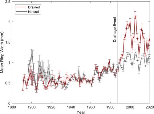
我们旨在评估泥炭地排水如何改变森林覆盖、地上生物量和树木生产力的时空变异,以及这些变化与泥炭燃烧严重程度的空间变异之间的关系。我们研究了加拿大阿尔伯塔省帕克兰县以黑云杉和桦树为主的北方泥炭地,该地区于1987年排干,并于2021年烧毁。利用遥感技术(历史图像和激光雷达),我们确定了排水后森林覆盖率增加了180%,地上树木生物量从最近排水沟附近的26.1 kg m - 2减少到距离最近排水沟95 m的2.8 kg m - 2。通过实地调查和基于激光雷达的分析来测量泥炭燃烧严重程度的空间变异性。排水泥炭地边缘经历了最大的泥炭燃烧严重程度,平均燃烧深度为26.9±12.6 cm(34.0±10.1 kg cm - 2),而自然中部为15.3±6.2 cm(8.3±2.1 kg cm - 2),其中泥炭燃烧严重程度随着靠近沟渠和地上生物量的增加而增加。我们提出了一个概念模型,概述了排水后地上和泥炭燃料负荷的增加,并建议由于造林反馈,受排水影响的沟渠周围面积(通常假设为30米)可能随着时间的推移而增加。排干的泥炭地对社区和消防管理机构来说是一个严重的火灾风险。泥炭地恢复应纳入燃料管理战略,以减少泥炭地干涸带来的风险。
Fuel Loads and Peat Smoldering Carbon Loss Increase Following Drainage in a Forested Boreal Peatland
We aimed to assess how peatland drainage altered the spatiotemporal variability in forest cover, aboveground biomass, and tree productivity and how these changes related to the spatial variability in peat burn severity. We studied a black spruce and birch dominated boreal peatland in Parkland County, Alberta, Canada, which was drained in 1987 and burned in 2021. Using remote sensing techniques (historical imagery and LiDAR), we determined that forest cover increased by 180% following drainage and aboveground tree biomass decreased from 26.1 kg m−2 adjacent to the nearest drainage ditch to 2.8 kg m−2 95 m away from the nearest ditch. Field surveys and a LiDAR-based analysis were conducted to measure the spatial variability in peat burn severity. Drained peatland margins experienced the greatest peat burn severity with a mean depth of burn of 26.9 ± 12.6 cm (18.2 ± 10.1 kg C m−2) compared to natural middles at 15.3 ± 6.2 cm (3.9 ± 2.1 kg C m−2), where peat burn severity increased with proximity to ditches and greater aboveground biomass. We present a conceptual model outlining the increases in aboveground and peat fuel loads following drainage and suggest that the area around a ditch that is impacted by drainage, which is commonly assumed to be 30 m, likely increases through time in forested peatlands due to the afforestation feedback. Drained peatlands represent a severe fire risk for communities and fire management agencies. Peatland restoration should be integrated into fuel management strategies to reduce the risk that drained peatlands pose.
期刊介绍:
JGR-Biogeosciences focuses on biogeosciences of the Earth system in the past, present, and future and the extension of this research to planetary studies. The emerging field of biogeosciences spans the intellectual interface between biology and the geosciences and attempts to understand the functions of the Earth system across multiple spatial and temporal scales. Studies in biogeosciences may use multiple lines of evidence drawn from diverse fields to gain a holistic understanding of terrestrial, freshwater, and marine ecosystems and extreme environments. Specific topics within the scope of the section include process-based theoretical, experimental, and field studies of biogeochemistry, biogeophysics, atmosphere-, land-, and ocean-ecosystem interactions, biomineralization, life in extreme environments, astrobiology, microbial processes, geomicrobiology, and evolutionary geobiology


 求助内容:
求助内容: 应助结果提醒方式:


