{"title":"使用校准曲线数和径流驱动的USLE模型估算Sparacia(西西里岛,意大利南部)地块的事件土壤流失量","authors":"Vincenzo Pampalone, Dario Autovino, Maria Angela Serio, Vincenzo Bagarello, Vito Ferro","doi":"10.1002/hyp.70205","DOIUrl":null,"url":null,"abstract":"<p>The Natural Resources Conservation Service (NRCS)-curve number (CN) method was originally proposed to predict runoff on small and midsize catchments, but it has also been used at the scale of erosion plots. In this case, uncertainties exist with reference to the factors, for example, scale effects, affecting the experimental CN values. In this study, the reliability of the CN method in reproducing plot runoff is analysed by using data collected at the Sparacia erosion plots (Sicily, Southern Italy), which are characterised by different sizes and steepness. This investigation aimed to test the possibility of using simulated runoff within universal soil loss equation (USLE)-type models, including runoff as a term in the erosivity factor. This analysis pointed out that the experimentally determined value of the initial abstraction ratio of the CN method was very low (0.0001). For each plot type (i.e., fixed length and steepness), the calibration was performed for 18 combinations of three rainfall ranges (all data, rainfall depth less than the median, and exceeding the median), two calibration approaches (least-squares and median value) and three datasets (all data, interrill, and rill). The best CN model fit was systematically produced for data with rainfall depth less than the median. The least-squares calibration approach generally performed slightly better than the median value one. Results showed that the CN method can be considered effective only for events producing rills. The CN values generally increased with plot steepness and decreased as plot length increased. For each plot type, CN tendentially increased for increasing soil moisture before the rainfall event, but moisture and rainfall depth were able to explain a minor part (from 19.5% to 41%) of CN variance. Finally, the USLE-MB that incorporates runoff simulated by the CN method was found to satisfactorily predict (relative standard error = 0.69, Nash and Sutcliffe Efficiency Index = 0.54) event soil loss caused by simultaneous interrill and rill erosion due to the higher rainfall depths recorded at the Sparacia station.</p>","PeriodicalId":13189,"journal":{"name":"Hydrological Processes","volume":"39 7","pages":""},"PeriodicalIF":2.9000,"publicationDate":"2025-07-11","publicationTypes":"Journal Article","fieldsOfStudy":null,"isOpenAccess":false,"openAccessPdf":"https://onlinelibrary.wiley.com/doi/epdf/10.1002/hyp.70205","citationCount":"0","resultStr":"{\"title\":\"Use of the Calibrated Curve Number and a Runoff-Driven USLE Model to Estimate Event Soil Loss From Sparacia (Sicily, Southern Italy) Plots\",\"authors\":\"Vincenzo Pampalone, Dario Autovino, Maria Angela Serio, Vincenzo Bagarello, Vito Ferro\",\"doi\":\"10.1002/hyp.70205\",\"DOIUrl\":null,\"url\":null,\"abstract\":\"<p>The Natural Resources Conservation Service (NRCS)-curve number (CN) method was originally proposed to predict runoff on small and midsize catchments, but it has also been used at the scale of erosion plots. In this case, uncertainties exist with reference to the factors, for example, scale effects, affecting the experimental CN values. In this study, the reliability of the CN method in reproducing plot runoff is analysed by using data collected at the Sparacia erosion plots (Sicily, Southern Italy), which are characterised by different sizes and steepness. This investigation aimed to test the possibility of using simulated runoff within universal soil loss equation (USLE)-type models, including runoff as a term in the erosivity factor. This analysis pointed out that the experimentally determined value of the initial abstraction ratio of the CN method was very low (0.0001). For each plot type (i.e., fixed length and steepness), the calibration was performed for 18 combinations of three rainfall ranges (all data, rainfall depth less than the median, and exceeding the median), two calibration approaches (least-squares and median value) and three datasets (all data, interrill, and rill). The best CN model fit was systematically produced for data with rainfall depth less than the median. The least-squares calibration approach generally performed slightly better than the median value one. Results showed that the CN method can be considered effective only for events producing rills. The CN values generally increased with plot steepness and decreased as plot length increased. For each plot type, CN tendentially increased for increasing soil moisture before the rainfall event, but moisture and rainfall depth were able to explain a minor part (from 19.5% to 41%) of CN variance. Finally, the USLE-MB that incorporates runoff simulated by the CN method was found to satisfactorily predict (relative standard error = 0.69, Nash and Sutcliffe Efficiency Index = 0.54) event soil loss caused by simultaneous interrill and rill erosion due to the higher rainfall depths recorded at the Sparacia station.</p>\",\"PeriodicalId\":13189,\"journal\":{\"name\":\"Hydrological Processes\",\"volume\":\"39 7\",\"pages\":\"\"},\"PeriodicalIF\":2.9000,\"publicationDate\":\"2025-07-11\",\"publicationTypes\":\"Journal Article\",\"fieldsOfStudy\":null,\"isOpenAccess\":false,\"openAccessPdf\":\"https://onlinelibrary.wiley.com/doi/epdf/10.1002/hyp.70205\",\"citationCount\":\"0\",\"resultStr\":null,\"platform\":\"Semanticscholar\",\"paperid\":null,\"PeriodicalName\":\"Hydrological Processes\",\"FirstCategoryId\":\"89\",\"ListUrlMain\":\"https://onlinelibrary.wiley.com/doi/10.1002/hyp.70205\",\"RegionNum\":3,\"RegionCategory\":\"地球科学\",\"ArticlePicture\":[],\"TitleCN\":null,\"AbstractTextCN\":null,\"PMCID\":null,\"EPubDate\":\"\",\"PubModel\":\"\",\"JCR\":\"Q1\",\"JCRName\":\"Environmental Science\",\"Score\":null,\"Total\":0}","platform":"Semanticscholar","paperid":null,"PeriodicalName":"Hydrological Processes","FirstCategoryId":"89","ListUrlMain":"https://onlinelibrary.wiley.com/doi/10.1002/hyp.70205","RegionNum":3,"RegionCategory":"地球科学","ArticlePicture":[],"TitleCN":null,"AbstractTextCN":null,"PMCID":null,"EPubDate":"","PubModel":"","JCR":"Q1","JCRName":"Environmental Science","Score":null,"Total":0}
Use of the Calibrated Curve Number and a Runoff-Driven USLE Model to Estimate Event Soil Loss From Sparacia (Sicily, Southern Italy) Plots
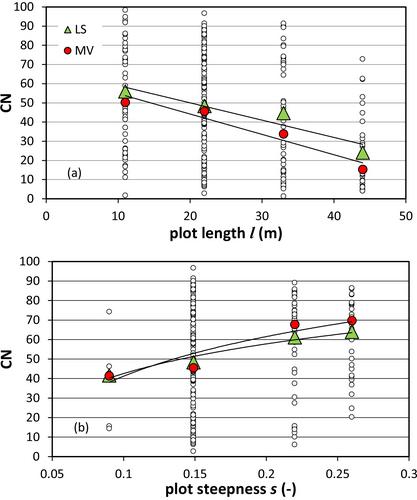
The Natural Resources Conservation Service (NRCS)-curve number (CN) method was originally proposed to predict runoff on small and midsize catchments, but it has also been used at the scale of erosion plots. In this case, uncertainties exist with reference to the factors, for example, scale effects, affecting the experimental CN values. In this study, the reliability of the CN method in reproducing plot runoff is analysed by using data collected at the Sparacia erosion plots (Sicily, Southern Italy), which are characterised by different sizes and steepness. This investigation aimed to test the possibility of using simulated runoff within universal soil loss equation (USLE)-type models, including runoff as a term in the erosivity factor. This analysis pointed out that the experimentally determined value of the initial abstraction ratio of the CN method was very low (0.0001). For each plot type (i.e., fixed length and steepness), the calibration was performed for 18 combinations of three rainfall ranges (all data, rainfall depth less than the median, and exceeding the median), two calibration approaches (least-squares and median value) and three datasets (all data, interrill, and rill). The best CN model fit was systematically produced for data with rainfall depth less than the median. The least-squares calibration approach generally performed slightly better than the median value one. Results showed that the CN method can be considered effective only for events producing rills. The CN values generally increased with plot steepness and decreased as plot length increased. For each plot type, CN tendentially increased for increasing soil moisture before the rainfall event, but moisture and rainfall depth were able to explain a minor part (from 19.5% to 41%) of CN variance. Finally, the USLE-MB that incorporates runoff simulated by the CN method was found to satisfactorily predict (relative standard error = 0.69, Nash and Sutcliffe Efficiency Index = 0.54) event soil loss caused by simultaneous interrill and rill erosion due to the higher rainfall depths recorded at the Sparacia station.
期刊介绍:
Hydrological Processes is an international journal that publishes original scientific papers advancing understanding of the mechanisms underlying the movement and storage of water in the environment, and the interaction of water with geological, biogeochemical, atmospheric and ecological systems. Not all papers related to water resources are appropriate for submission to this journal; rather we seek papers that clearly articulate the role(s) of hydrological processes.

 求助内容:
求助内容: 应助结果提醒方式:


