Eka Mutia, Azmeri Azmeri, Alfiansyah Yulianur, Ashfa Achmad, Ella Meilianda
{"title":"基于综合脆弱性指数的城市雨洪多因素分析。","authors":"Eka Mutia, Azmeri Azmeri, Alfiansyah Yulianur, Ashfa Achmad, Ella Meilianda","doi":"10.4102/jamba.v17i1.1835","DOIUrl":null,"url":null,"abstract":"<p><p>Urbanity is facing a growing threat of pluvial flooding due to rampant urbanisation and transformations combined with insufficient drainage systems. This situation becomes aggravated by flat topography and heavy rainfall, especially in poorly drained areas. Assessing flood vulnerability at the community level using the Flood Vulnerability Index (FVI) is essential for effective urban planning and flood risk management. The FVI consists of four key components: physical, environmental, social and economic. Physical factors encompass topography, rainfall and drainage systems, while environmental factors involve green spaces and retention zones. Social factors pertain to population density and community awareness, whereas economic factors relate to potential revenue losses and recovery capacity. The FVI was calculated using both secondary data and field observations, based on exposure, sensitivity and adaptive capacity. High population density, low green area ratio and poor drainage conditions are associated with high FVI, while when accompanied by higher environmental support and adaptive capacity in the community, lower vulnerability was observed.</p><p><strong>Contribution: </strong>This study highlights the comprehensive application of the FVI in urban flood risk management. The findings emphasise the need for systematic improvements in drainage infrastructure, sustainable management of natural resources and strategic land-use planning to enhance flood risk reduction. These insights provide a valuable contribution to the advancement of flood risk assessment and management frameworks, supporting more resilient urban planning strategies.</p>","PeriodicalId":51823,"journal":{"name":"Jamba-Journal of Disaster Risk Studies","volume":"17 1","pages":"1835"},"PeriodicalIF":1.7000,"publicationDate":"2025-06-18","publicationTypes":"Journal Article","fieldsOfStudy":null,"isOpenAccess":false,"openAccessPdf":"https://www.ncbi.nlm.nih.gov/pmc/articles/PMC12224025/pdf/","citationCount":"0","resultStr":"{\"title\":\"Multifactor analysis of urban pluvial flooding using a comprehensive vulnerability index.\",\"authors\":\"Eka Mutia, Azmeri Azmeri, Alfiansyah Yulianur, Ashfa Achmad, Ella Meilianda\",\"doi\":\"10.4102/jamba.v17i1.1835\",\"DOIUrl\":null,\"url\":null,\"abstract\":\"<p><p>Urbanity is facing a growing threat of pluvial flooding due to rampant urbanisation and transformations combined with insufficient drainage systems. This situation becomes aggravated by flat topography and heavy rainfall, especially in poorly drained areas. Assessing flood vulnerability at the community level using the Flood Vulnerability Index (FVI) is essential for effective urban planning and flood risk management. The FVI consists of four key components: physical, environmental, social and economic. Physical factors encompass topography, rainfall and drainage systems, while environmental factors involve green spaces and retention zones. Social factors pertain to population density and community awareness, whereas economic factors relate to potential revenue losses and recovery capacity. The FVI was calculated using both secondary data and field observations, based on exposure, sensitivity and adaptive capacity. High population density, low green area ratio and poor drainage conditions are associated with high FVI, while when accompanied by higher environmental support and adaptive capacity in the community, lower vulnerability was observed.</p><p><strong>Contribution: </strong>This study highlights the comprehensive application of the FVI in urban flood risk management. The findings emphasise the need for systematic improvements in drainage infrastructure, sustainable management of natural resources and strategic land-use planning to enhance flood risk reduction. These insights provide a valuable contribution to the advancement of flood risk assessment and management frameworks, supporting more resilient urban planning strategies.</p>\",\"PeriodicalId\":51823,\"journal\":{\"name\":\"Jamba-Journal of Disaster Risk Studies\",\"volume\":\"17 1\",\"pages\":\"1835\"},\"PeriodicalIF\":1.7000,\"publicationDate\":\"2025-06-18\",\"publicationTypes\":\"Journal Article\",\"fieldsOfStudy\":null,\"isOpenAccess\":false,\"openAccessPdf\":\"https://www.ncbi.nlm.nih.gov/pmc/articles/PMC12224025/pdf/\",\"citationCount\":\"0\",\"resultStr\":null,\"platform\":\"Semanticscholar\",\"paperid\":null,\"PeriodicalName\":\"Jamba-Journal of Disaster Risk Studies\",\"FirstCategoryId\":\"1085\",\"ListUrlMain\":\"https://doi.org/10.4102/jamba.v17i1.1835\",\"RegionNum\":0,\"RegionCategory\":null,\"ArticlePicture\":[],\"TitleCN\":null,\"AbstractTextCN\":null,\"PMCID\":null,\"EPubDate\":\"2025/1/1 0:00:00\",\"PubModel\":\"eCollection\",\"JCR\":\"Q2\",\"JCRName\":\"SOCIAL SCIENCES, INTERDISCIPLINARY\",\"Score\":null,\"Total\":0}","platform":"Semanticscholar","paperid":null,"PeriodicalName":"Jamba-Journal of Disaster Risk Studies","FirstCategoryId":"1085","ListUrlMain":"https://doi.org/10.4102/jamba.v17i1.1835","RegionNum":0,"RegionCategory":null,"ArticlePicture":[],"TitleCN":null,"AbstractTextCN":null,"PMCID":null,"EPubDate":"2025/1/1 0:00:00","PubModel":"eCollection","JCR":"Q2","JCRName":"SOCIAL SCIENCES, INTERDISCIPLINARY","Score":null,"Total":0}
Multifactor analysis of urban pluvial flooding using a comprehensive vulnerability index.
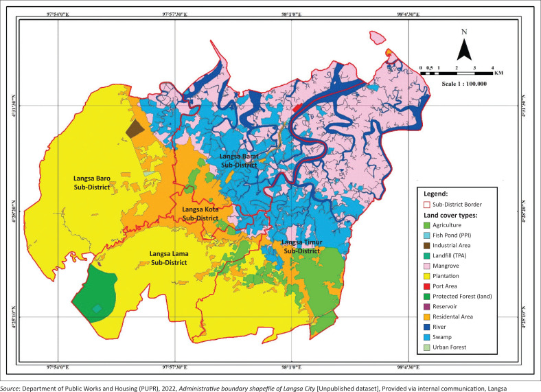
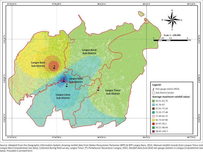
Urbanity is facing a growing threat of pluvial flooding due to rampant urbanisation and transformations combined with insufficient drainage systems. This situation becomes aggravated by flat topography and heavy rainfall, especially in poorly drained areas. Assessing flood vulnerability at the community level using the Flood Vulnerability Index (FVI) is essential for effective urban planning and flood risk management. The FVI consists of four key components: physical, environmental, social and economic. Physical factors encompass topography, rainfall and drainage systems, while environmental factors involve green spaces and retention zones. Social factors pertain to population density and community awareness, whereas economic factors relate to potential revenue losses and recovery capacity. The FVI was calculated using both secondary data and field observations, based on exposure, sensitivity and adaptive capacity. High population density, low green area ratio and poor drainage conditions are associated with high FVI, while when accompanied by higher environmental support and adaptive capacity in the community, lower vulnerability was observed.
Contribution: This study highlights the comprehensive application of the FVI in urban flood risk management. The findings emphasise the need for systematic improvements in drainage infrastructure, sustainable management of natural resources and strategic land-use planning to enhance flood risk reduction. These insights provide a valuable contribution to the advancement of flood risk assessment and management frameworks, supporting more resilient urban planning strategies.

 求助内容:
求助内容: 应助结果提醒方式:


