沿海水域蓝藻有害藻华扩张的气候驱动预测
IF 8
1区 环境科学与生态学
Q1 ENVIRONMENTAL SCIENCES
引用次数: 0
摘要
沿海水域的蓝藻有害藻华(CyanoHABs)是一个日益严重的生态和环境问题,特别是在气候脆弱地区。虽然许多研究已经探索了蓝藻有害藻华的历史变化和短期预测,但本研究将预测扩展到未来几十年,重点关注未来气候变化情景下阿曼脆弱的沿海地区。通过将环流模型(GCMs)输出与机器学习和深度学习模型相结合,本研究旨在提高预测准确性并评估氰化赤藻的长期影响。历史卫星数据(2003-2024年)显示,阿曼东海岸叶绿素-a (Chl-a)水平升高,特别是Muḥūt、Ad Duqm和Al jazjazr附近。由于沿海水域营养丰富,这些地区容易形成水华。利用MODIS卫星图像和浮藻指数(FAI)估算蓝藻hab面积,并利用Landsat 7数据进行验证(R2 = 0.925-0.968)。对2000年至2020年957张卫星图像的分析显示,蓝藻赤潮的出现有所增加,尤其是在夏季。主成分分析发现风速、温度和降水是主要的环境驱动因素。为了预测未来的蓝藻hab区域,使用粒子群优化技术对ML和DL模型进行了微调,包括随机森林、极端梯度增强、门控循环单元和长短期记忆(LSTM)。LSTM优于其他模型,Sobol分析显示降水是最敏感的参数。利用SSP126、SSP245和SSP585三种高性能gcm对三个时期(2030-2089)进行了预估。结果表明,蓝藻有害藻区总体呈增加趋势,在高排放情景下增幅最大,需要进行适应性管理和减缓。本文章由计算机程序翻译,如有差异,请以英文原文为准。
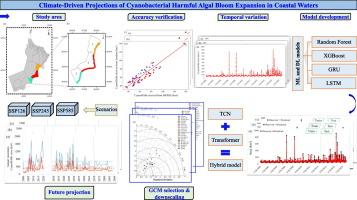
Climate-driven projections of cyanobacterial harmful algal bloom expansion in coastal waters
Cyanobacterial harmful algal blooms (CyanoHABs) in coastal waters are a growing ecological and environmental concern, especially in climate-vulnerable regions. While many studies have explored historical variations and short-term forecasting of CyanoHABs, this study extends projections into the coming decades, focusing on Oman's vulnerable coastal areas under future climate change scenarios. By integrating General Circulation Models (GCMs) outputs with machine learning and deep learning models, this research aims to enhance predictive accuracy and assess long-term CyanoHAB impacts. Historical satellite data (2003–2024) show elevated chlorophyll-a (Chl-a) levels along Oman's eastern coast, particularly near Muḥūt, Ad Duqm, and Al Jazīr. These areas are susceptible to bloom formation due to nutrient-rich coastal waters. MODIS satellite imagery and the Floating Algae Index (FAI) were used to estimate CyanoHAB areas, with Landsat 7 data providing validation (R2 = 0.925–0.968). Analysis of 957 satellite images from 2000 to 2020 revealed an increase in CyanoHAB occurrences, especially in summer. Principal Component Analysis identified wind speed, temperature, and precipitation as key environmental drivers. To project future CyanoHAB areas, ML and DL models, including Random Forest, Extreme Gradient Boosting, Gated Recurrent Unit, and Long Short-Term Memory (LSTM), were fine-tuned using Particle Swarm Optimization. LSTM outperformed other models, and Sobol analysis revealed precipitation as the most sensitive parameter. Projections were made using three high-performing GCMs under SSP126, SSP245, and SSP585 scenarios for three periods (2030–2089). Results indicated a general increase in CyanoHAB areas, with the highest increase under high emission scenarios, requiring adaptive management and mitigation.
求助全文
通过发布文献求助,成功后即可免费获取论文全文。
去求助
来源期刊

Science of the Total Environment
环境科学-环境科学
CiteScore
17.60
自引率
10.20%
发文量
8726
审稿时长
2.4 months
期刊介绍:
The Science of the Total Environment is an international journal dedicated to scientific research on the environment and its interaction with humanity. It covers a wide range of disciplines and seeks to publish innovative, hypothesis-driven, and impactful research that explores the entire environment, including the atmosphere, lithosphere, hydrosphere, biosphere, and anthroposphere.
The journal's updated Aims & Scope emphasizes the importance of interdisciplinary environmental research with broad impact. Priority is given to studies that advance fundamental understanding and explore the interconnectedness of multiple environmental spheres. Field studies are preferred, while laboratory experiments must demonstrate significant methodological advancements or mechanistic insights with direct relevance to the environment.
 求助内容:
求助内容: 应助结果提醒方式:


