印度中部印度构造带的三维地壳电阻率图像:来自大地电磁研究
IF 2.4
3区 地球科学
Q2 GEOSCIENCES, MULTIDISCIPLINARY
引用次数: 0
摘要
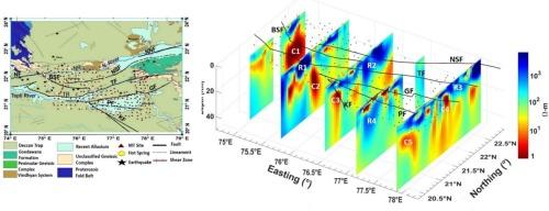
过去提出了一些地震和二维电阻率模型,以了解包括Narmada-Son线(NSL)带在内的印度中部构造带(CITZ)的构造背景。该地区受到几条已知和未知断层的高度干扰,即Barwani Sukta断层、Gavligarh断层、Kaddam断层、Narmada South断层、Purna断层和Tapti断层,这些断层既有浅层的,也有深层的。鉴于该地区存在大量构造特征,有必要对MT资料进行三维反演。在74.76 - 78°E和20°40′- 22.5°N之间,273个站点以网格方式获取不同阶段的宽带MT数据,对CITZ进行成像。虽然之前进行的2D研究很少,但这是第一次对CITZ中心区域进行3D研究,以导出研究区域的3D地下电阻率模型。导出的三维电阻率模型描绘了几个主要的地壳导体、断层边界和电阻基底。我们将三维电阻率模型与该地区以前的大地电磁测深剖面进行了对比。深层导体(~ 10 Ωm)对应于白垩纪-第三纪德干火山活动期间基性岩浆和/或流体侵入的底板,受深层断裂控制。浅深部局部断层支持流体的向上运动。电阻结构(>1000 Ωm)对应于地下室。研究表明,纳尔马达河和塔提河之间存在基底隆起。高热流、高地震速度和低电阻率结构与中、下地壳导体有关,与岩浆底板和主要断裂带有关。这些对比有助于研究和解释该地区断层的特征和行为。本文章由计算机程序翻译,如有差异,请以英文原文为准。
Three-dimensional crustal resistivity image of the central Indian tectonic zone, India: derived from magnetotelluric studies
A few seismic and 2D resistivity models were presented in the past to understand the tectonic setting of the Central Indian Tectonic Zone (CITZ) comprising the Narmada-Son Lineament (NSL) zone. The region is highly disturbed and bounded by several known and unknown faults, namely, Barwani Sukta Fault, Gavligarh Fault, Kaddam Fault, Narmada South Fault, Purna Fault, and Tapti Fault, both shallow and deep-seated. In view of the presence of large number of tectonic features in the area, it seems necessary to perform the 3D inversion of MT data. Broadband MT data were acquired at 273 stations in different phases in a gridded fashion between 74.76 and 78°E and 20°40 ’ to 22.5°N to image the CITZ. Although, few 2D studies were done earlier this is the first 3D study of the central region of CITZ, to derive the 3D subsurface resistivity model of the study area. The derived 3D resistivity model delineates several major crustal conductors, fault boundaries, and the resistive basement. We correlated the present 3D resistivity model with previous magnetotelluric and deep seismic sounding profiles of the region. The deep-seated conductors (∼10 Ωm) correspond to the underplating of mafic magmatic and/or fluid intrusions during the Cretaceous-Tertiary Deccan volcanism and are controlled by the deep-seated faults. The shallow depth localized faults support the upward movement of fluid present. The resistive structure (>1000 Ωm) corresponds to the basement. The study shows a basement uplift between the Narmada and Tapti rivers. The high heat flow, high seismic velocity, and low-resistivity structures correlate with mid to lower crustal conductors associated with the magmatic underplating and major fault zones in the NSL. These correlations help to study and interpret the characteristics and behaviour of faulting in the region.
求助全文
通过发布文献求助,成功后即可免费获取论文全文。
去求助
来源期刊
Journal of Asian Earth Sciences
地学-地球科学综合
CiteScore
5.90
自引率
10.00%
发文量
324
审稿时长
71 days
期刊介绍:
Journal of Asian Earth Sciences has an open access mirror journal Journal of Asian Earth Sciences: X, sharing the same aims and scope, editorial team, submission system and rigorous peer review.
The Journal of Asian Earth Sciences is an international interdisciplinary journal devoted to all aspects of research related to the solid Earth Sciences of Asia. The Journal publishes high quality, peer-reviewed scientific papers on the regional geology, tectonics, geochemistry and geophysics of Asia. It will be devoted primarily to research papers but short communications relating to new developments of broad interest, reviews and book reviews will also be included. Papers must have international appeal and should present work of more than local significance.
The scope includes deep processes of the Asian continent and its adjacent oceans; seismology and earthquakes; orogeny, magmatism, metamorphism and volcanism; growth, deformation and destruction of the Asian crust; crust-mantle interaction; evolution of life (early life, biostratigraphy, biogeography and mass-extinction); fluids, fluxes and reservoirs of mineral and energy resources; surface processes (weathering, erosion, transport and deposition of sediments) and resulting geomorphology; and the response of the Earth to global climate change as viewed within the Asian continent and surrounding oceans.
 求助内容:
求助内容: 应助结果提醒方式:


