整合地理空间和水动力模型,揭示干旱环境中文化遗产对溃坝和山洪的脆弱性

IF 4.5 1区 地球科学 Q1 GEOSCIENCES, MULTIDISCIPLINARY
Youssef M. Youssef , Wael M. AlMetwaly , Mohamed Saber , Mahmoud Abdelshafy , Saleh Qaysi , Nassir Alarifi , Mohamed Wahba
{"title":"整合地理空间和水动力模型,揭示干旱环境中文化遗产对溃坝和山洪的脆弱性","authors":"Youssef M. Youssef ,&nbsp;Wael M. AlMetwaly ,&nbsp;Mohamed Saber ,&nbsp;Mahmoud Abdelshafy ,&nbsp;Saleh Qaysi ,&nbsp;Nassir Alarifi ,&nbsp;Mohamed Wahba","doi":"10.1016/j.ijdrr.2025.105605","DOIUrl":null,"url":null,"abstract":"<div><div>Climate change has exacerbated droughts and flash floods, particularly in arid and semi-arid regions, posing significant threats to cultural heritage worldwide. Despite advances in geospatial and hydrodynamic modeling, the vulnerability of Arabian cultural sites to flash floods-especially those triggered by dam breaches and extreme storms over unprotected watersheds-remains largely unexamined. This study integrates Sentinel-2, ALOS-DEM, IMERG-based rainfall data, and ancillary datasets within a Machine Learning-based Support Vector Machine (SVM) framework, coupled with hydrodynamic simulations, to assess cultural susceptibility in Najran, a culturally significant region in southern Saudi Arabia. The Flash Flood Hazard Susceptibility (FFHS) map achieved an AUC of 0.9, with 76.47 % of flood-affected areas concentrated in high-susceptibility zones. The susceptibility classification includes very low (23.79 %), low (32.83 %), moderate (25.16 %), high (13.66 %), and very high (4.57 %) zones. Hydrograph analysis estimated peak discharges of 40,000 m<sup>3</sup>/s for the dam breach scenario (case a) and 100,000 m<sup>3</sup>/s when combined with downstream precipitation (case b). The 100-year flood inundation scenario (case b) projected flood depths of 12 m at Al-Aan Palace, 10 m at Al-Lijam Village, 9.5 m at Al-Amer, 8.5 m at Al-Manjam Village, and 7 m at Al-Okhdood, with corresponding flow velocities of 3.5 m/s, 9 m/s, 5 m/s, 3 m/s, and 4 m/s, respectively, while Raoum Castle remained unaffected. Notably, Al-Okhdood, the oldest archaeological site dating to the 7th century BC, faces complete submersion. These findings underscore the urgent need for early warning systems and enhanced collaboration between researchers and cultural authorities to protect heritage in Arabian nations.</div></div>","PeriodicalId":13915,"journal":{"name":"International journal of disaster risk reduction","volume":"126 ","pages":"Article 105605"},"PeriodicalIF":4.5000,"publicationDate":"2025-05-28","publicationTypes":"Journal Article","fieldsOfStudy":null,"isOpenAccess":false,"openAccessPdf":"","citationCount":"0","resultStr":"{\"title\":\"Integrating geospatial and hydrodynamic modelling to unravel cultural heritage vulnerability to dam breaches and flash flood in arid environments\",\"authors\":\"Youssef M. Youssef ,&nbsp;Wael M. AlMetwaly ,&nbsp;Mohamed Saber ,&nbsp;Mahmoud Abdelshafy ,&nbsp;Saleh Qaysi ,&nbsp;Nassir Alarifi ,&nbsp;Mohamed Wahba\",\"doi\":\"10.1016/j.ijdrr.2025.105605\",\"DOIUrl\":null,\"url\":null,\"abstract\":\"<div><div>Climate change has exacerbated droughts and flash floods, particularly in arid and semi-arid regions, posing significant threats to cultural heritage worldwide. Despite advances in geospatial and hydrodynamic modeling, the vulnerability of Arabian cultural sites to flash floods-especially those triggered by dam breaches and extreme storms over unprotected watersheds-remains largely unexamined. This study integrates Sentinel-2, ALOS-DEM, IMERG-based rainfall data, and ancillary datasets within a Machine Learning-based Support Vector Machine (SVM) framework, coupled with hydrodynamic simulations, to assess cultural susceptibility in Najran, a culturally significant region in southern Saudi Arabia. The Flash Flood Hazard Susceptibility (FFHS) map achieved an AUC of 0.9, with 76.47 % of flood-affected areas concentrated in high-susceptibility zones. The susceptibility classification includes very low (23.79 %), low (32.83 %), moderate (25.16 %), high (13.66 %), and very high (4.57 %) zones. Hydrograph analysis estimated peak discharges of 40,000 m<sup>3</sup>/s for the dam breach scenario (case a) and 100,000 m<sup>3</sup>/s when combined with downstream precipitation (case b). The 100-year flood inundation scenario (case b) projected flood depths of 12 m at Al-Aan Palace, 10 m at Al-Lijam Village, 9.5 m at Al-Amer, 8.5 m at Al-Manjam Village, and 7 m at Al-Okhdood, with corresponding flow velocities of 3.5 m/s, 9 m/s, 5 m/s, 3 m/s, and 4 m/s, respectively, while Raoum Castle remained unaffected. Notably, Al-Okhdood, the oldest archaeological site dating to the 7th century BC, faces complete submersion. These findings underscore the urgent need for early warning systems and enhanced collaboration between researchers and cultural authorities to protect heritage in Arabian nations.</div></div>\",\"PeriodicalId\":13915,\"journal\":{\"name\":\"International journal of disaster risk reduction\",\"volume\":\"126 \",\"pages\":\"Article 105605\"},\"PeriodicalIF\":4.5000,\"publicationDate\":\"2025-05-28\",\"publicationTypes\":\"Journal Article\",\"fieldsOfStudy\":null,\"isOpenAccess\":false,\"openAccessPdf\":\"\",\"citationCount\":\"0\",\"resultStr\":null,\"platform\":\"Semanticscholar\",\"paperid\":null,\"PeriodicalName\":\"International journal of disaster risk reduction\",\"FirstCategoryId\":\"89\",\"ListUrlMain\":\"https://www.sciencedirect.com/science/article/pii/S2212420925004297\",\"RegionNum\":1,\"RegionCategory\":\"地球科学\",\"ArticlePicture\":[],\"TitleCN\":null,\"AbstractTextCN\":null,\"PMCID\":null,\"EPubDate\":\"\",\"PubModel\":\"\",\"JCR\":\"Q1\",\"JCRName\":\"GEOSCIENCES, MULTIDISCIPLINARY\",\"Score\":null,\"Total\":0}","platform":"Semanticscholar","paperid":null,"PeriodicalName":"International journal of disaster risk reduction","FirstCategoryId":"89","ListUrlMain":"https://www.sciencedirect.com/science/article/pii/S2212420925004297","RegionNum":1,"RegionCategory":"地球科学","ArticlePicture":[],"TitleCN":null,"AbstractTextCN":null,"PMCID":null,"EPubDate":"","PubModel":"","JCR":"Q1","JCRName":"GEOSCIENCES, MULTIDISCIPLINARY","Score":null,"Total":0}
引用次数: 0

摘要

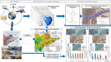
气候变化加剧了干旱和山洪暴发,特别是在干旱和半干旱地区,对世界各地的文化遗产构成了重大威胁。尽管地理空间和水动力学建模技术取得了进步,但阿拉伯文化遗址面对洪水的脆弱性——尤其是那些由大坝决口和未受保护的流域极端风暴引发的洪水——在很大程度上仍未得到研究。本研究在基于机器学习的支持向量机(SVM)框架内整合了Sentinel-2、ALOS-DEM、基于imergs的降雨数据和辅助数据集,并结合水动力学模拟,以评估沙特阿拉伯南部文化重要地区Najran的文化敏感性。山洪灾害易感性(FFHS)图的AUC为0.9,76.47%的受灾地区集中在高易感性区。易感区分为极低区(23.79%)、低区(32.83%)、中区(25.16%)、高区(13.66%)和极高区(4.57%)。水文曲线分析估计,溃坝情景(情况a)的峰值流量为40000立方米/秒,结合下游降水(情况b)的峰值流量为100000立方米/秒。100年洪水淹没情景(案例b)预测Al-Aan宫殿的洪水深度为12米,Al-Lijam村为10米,Al-Amer村为9.5米,Al-Manjam村为8.5米,Al-Okhdood村为7米,相应的流速分别为3.5米/秒、9米/秒、5米/秒、3米/秒和4米/秒,而Raoum城堡不受影响。值得注意的是,Al-Okhdood是公元前7世纪最古老的考古遗址,它面临着完全淹没的危险。这些发现强调了建立早期预警系统和加强研究人员与文化当局之间的合作以保护阿拉伯国家遗产的迫切需要。
本文章由计算机程序翻译,如有差异,请以英文原文为准。

Integrating geospatial and hydrodynamic modelling to unravel cultural heritage vulnerability to dam breaches and flash flood in arid environments

Integrating geospatial and hydrodynamic modelling to unravel cultural heritage vulnerability to dam breaches and flash flood in arid environments
Climate change has exacerbated droughts and flash floods, particularly in arid and semi-arid regions, posing significant threats to cultural heritage worldwide. Despite advances in geospatial and hydrodynamic modeling, the vulnerability of Arabian cultural sites to flash floods-especially those triggered by dam breaches and extreme storms over unprotected watersheds-remains largely unexamined. This study integrates Sentinel-2, ALOS-DEM, IMERG-based rainfall data, and ancillary datasets within a Machine Learning-based Support Vector Machine (SVM) framework, coupled with hydrodynamic simulations, to assess cultural susceptibility in Najran, a culturally significant region in southern Saudi Arabia. The Flash Flood Hazard Susceptibility (FFHS) map achieved an AUC of 0.9, with 76.47 % of flood-affected areas concentrated in high-susceptibility zones. The susceptibility classification includes very low (23.79 %), low (32.83 %), moderate (25.16 %), high (13.66 %), and very high (4.57 %) zones. Hydrograph analysis estimated peak discharges of 40,000 m3/s for the dam breach scenario (case a) and 100,000 m3/s when combined with downstream precipitation (case b). The 100-year flood inundation scenario (case b) projected flood depths of 12 m at Al-Aan Palace, 10 m at Al-Lijam Village, 9.5 m at Al-Amer, 8.5 m at Al-Manjam Village, and 7 m at Al-Okhdood, with corresponding flow velocities of 3.5 m/s, 9 m/s, 5 m/s, 3 m/s, and 4 m/s, respectively, while Raoum Castle remained unaffected. Notably, Al-Okhdood, the oldest archaeological site dating to the 7th century BC, faces complete submersion. These findings underscore the urgent need for early warning systems and enhanced collaboration between researchers and cultural authorities to protect heritage in Arabian nations.
求助全文
通过发布文献求助,成功后即可免费获取论文全文。 去求助
来源期刊
International journal of disaster risk reduction
International journal of disaster risk reduction GEOSCIENCES, MULTIDISCIPLINARYMETEOROLOGY-METEOROLOGY & ATMOSPHERIC SCIENCES
CiteScore
8.70
自引率
18.00%
发文量
688
审稿时长
79 days
期刊介绍: The International Journal of Disaster Risk Reduction (IJDRR) is the journal for researchers, policymakers and practitioners across diverse disciplines: earth sciences and their implications; environmental sciences; engineering; urban studies; geography; and the social sciences. IJDRR publishes fundamental and applied research, critical reviews, policy papers and case studies with a particular focus on multi-disciplinary research that aims to reduce the impact of natural, technological, social and intentional disasters. IJDRR stimulates exchange of ideas and knowledge transfer on disaster research, mitigation, adaptation, prevention and risk reduction at all geographical scales: local, national and international. Key topics:- -multifaceted disaster and cascading disasters -the development of disaster risk reduction strategies and techniques -discussion and development of effective warning and educational systems for risk management at all levels -disasters associated with climate change -vulnerability analysis and vulnerability trends -emerging risks -resilience against disasters. The journal particularly encourages papers that approach risk from a multi-disciplinary perspective.
×
引用
GB/T 7714-2015
复制
MLA
复制
APA
复制
导出至
BibTeX EndNote RefMan NoteFirst NoteExpress
×
提示
您的信息不完整,为了账户安全,请先补充。
现在去补充
×
提示
您因"违规操作"
具体请查看互助需知
我知道了
×
提示
确定
请完成安全验证×
copy
已复制链接
快去分享给好友吧!
我知道了
右上角分享
点击右上角分享
0
联系我们:info@booksci.cn Book学术提供免费学术资源搜索服务,方便国内外学者检索中英文文献。致力于提供最便捷和优质的服务体验。 Copyright © 2023 布克学术 All rights reserved.
京ICP备2023020795号-1
ghs 京公网安备 11010802042870号
Book学术文献互助
Book学术文献互助群
群 号:604180095
Book学术官方微信