上Tietê盆地(巴西圣保罗)污染地区对水井和含水层潜在影响的空间分析
IF 4.4
3区 环境科学与生态学
Q2 ENVIRONMENTAL SCIENCES
引用次数: 0
摘要
上游Tietê是巴西圣保罗本文章由计算机程序翻译,如有差异,请以英文原文为准。
Spatial analysis of the potential impacts of contaminated areas in the Upper Tietê Basin (São Paulo, Brazil) on wells and aquifers
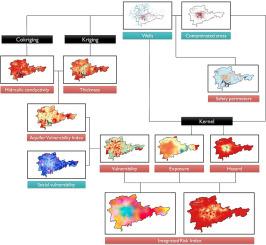
The Upper Tietê is prominent for being the basin with the highest contaminated areas in São Paulo, Brazil, and these areas significantly compromise the quality of groundwater in the basin, directly affecting the resident population. Acknowledging the criticality of formulating indicators for effective aquifer management, we attempted to identify and assess the risk, vulnerability, and contamination degrees of aquifers and wells in the Upper Tietê Basin. To do this, we applied the aquifer vulnerability index (AVI) method to evaluate the aquifer vulnerability in the region; the delineation and identification of wellhead protection areas and at-risk wells, respectively; and the integrated risk index by integrating the data on social and aquifer vulnerabilities, hazards, and exposure. As inputs for AVI analysis, we estimated the hydraulic conductivity and unsaturated-sedimentary-layer thickness of the aquifers. The hydraulic activity, which was estimated by an empirical flow method incorporating pipe-radius data, was interpolated by co-kriging (using well-flow parameters as auxiliary variables), and unsaturated thickness was interpolated by ordinary kriging. The results revealed the high vulnerability of the aquifers to contamination, mainly because of their minimal unsaturated-layer thicknesses. Furthermore, 7958 at-risk wells were identified around the basin (77.15 %), and the outskirts of the basin accounted for the most vulnerable municipalities. Further, the wellhead protection areas were also delimited by interpolating stabilization flow by indicator kriging. Furthermore, we developed an innovative social vulnerability indicator for groundwater usage and integrated it with AVI analysis. Overall, our findings offer relevant insights into aquifer management and contamination control, mainly because of the holistic approach, serving as a basis for identifying regions with the highest contamination risks for timely prevention and mitigation through appropriate actions.
求助全文
通过发布文献求助,成功后即可免费获取论文全文。
去求助
来源期刊
Journal of contaminant hydrology
环境科学-地球科学综合
CiteScore
6.80
自引率
2.80%
发文量
129
审稿时长
68 days
期刊介绍:
The Journal of Contaminant Hydrology is an international journal publishing scientific articles pertaining to the contamination of subsurface water resources. Emphasis is placed on investigations of the physical, chemical, and biological processes influencing the behavior and fate of organic and inorganic contaminants in the unsaturated (vadose) and saturated (groundwater) zones, as well as at groundwater-surface water interfaces. The ecological impacts of contaminants transported both from and to aquifers are of interest. Articles on contamination of surface water only, without a link to groundwater, are out of the scope. Broad latitude is allowed in identifying contaminants of interest, and include legacy and emerging pollutants, nutrients, nanoparticles, pathogenic microorganisms (e.g., bacteria, viruses, protozoa), microplastics, and various constituents associated with energy production (e.g., methane, carbon dioxide, hydrogen sulfide).
The journal''s scope embraces a wide range of topics including: experimental investigations of contaminant sorption, diffusion, transformation, volatilization and transport in the surface and subsurface; characterization of soil and aquifer properties only as they influence contaminant behavior; development and testing of mathematical models of contaminant behaviour; innovative techniques for restoration of contaminated sites; development of new tools or techniques for monitoring the extent of soil and groundwater contamination; transformation of contaminants in the hyporheic zone; effects of contaminants traversing the hyporheic zone on surface water and groundwater ecosystems; subsurface carbon sequestration and/or turnover; and migration of fluids associated with energy production into groundwater.
 求助内容:
求助内容: 应助结果提醒方式:


