基于机载激光扫描的社区尺度小气候模拟和基于目标的城市树木分类

IF 9.2 1区 环境科学与生态学 Q1 ECOLOGY
Xihan Yao , Minho Kim , Iryna Dronova , Joe R. McBride , G. Mathias Kondolf , John D. Radke
{"title":"基于机载激光扫描的社区尺度小气候模拟和基于目标的城市树木分类","authors":"Xihan Yao ,&nbsp;Minho Kim ,&nbsp;Iryna Dronova ,&nbsp;Joe R. McBride ,&nbsp;G. Mathias Kondolf ,&nbsp;John D. Radke","doi":"10.1016/j.landurbplan.2025.105420","DOIUrl":null,"url":null,"abstract":"<div><div>Urban climate and urban heat island effects, resulting from urban development and expansion, significantly impact human health and well-being. Urban forests play a vital role in regulating urban climate by cooling the ambient environment through shade and evapotranspiration, among many essential ecosystem services. Different human communities have distinct abundances, compositions, and patterns of urban forests, leading to varied cooling effectiveness and microclimate outcomes. While the general consensus is that planting more trees yields greater benefits, there is an increasing need to understand and document the forests’ varied taxonomical, structural, and biophysical properties at a more granular scale. This understanding is crucial to predicting and comparing the consequent microclimate conditions across communities. In this study, we utilize high-density airborne point cloud data (58 pulses per m<sup>2</sup>) to differentiate trees based on their vertical and internal structures. We create a tree family and size classification map for all trees in two socioeconomically distinct communities in Portland, Oregon, USA. The Random Forest classifier, using Lidar-derived metrics, classifies all tree objects into seven classes with an overall accuracy of 67.1 %. Using the classified properties, we simulate and compare these forests’ combined air temperature cooling effects and test alternative tree composition scenarios with the object-based ENVI-met model. The simulation results indicate that wealthier communities experience a more significant reduction in 1.5-meter-above-ground air temperature than less wealthy communities (0.23 K cooler on average). This disparity in benefits is likely to widen further if current forest evolution trends persist. This study demonstrates a comprehensive workflow from generating object-based knowledge on urban trees to high spatial resolution microclimate simulation of the urban forests’ composite effects. This approach can aid in practical urban forest quality monitoring and evaluation, supplement urban planning and management practices, and optimize the urban forest to facilitate cross-community ecosystem services equity.</div></div>","PeriodicalId":54744,"journal":{"name":"Landscape and Urban Planning","volume":"263 ","pages":"Article 105420"},"PeriodicalIF":9.2000,"publicationDate":"2025-06-02","publicationTypes":"Journal Article","fieldsOfStudy":null,"isOpenAccess":false,"openAccessPdf":"","citationCount":"0","resultStr":"{\"title\":\"Community-scale microclimate simulation using Airborne Laser Scanning and object-based urban tree classification\",\"authors\":\"Xihan Yao ,&nbsp;Minho Kim ,&nbsp;Iryna Dronova ,&nbsp;Joe R. McBride ,&nbsp;G. Mathias Kondolf ,&nbsp;John D. Radke\",\"doi\":\"10.1016/j.landurbplan.2025.105420\",\"DOIUrl\":null,\"url\":null,\"abstract\":\"<div><div>Urban climate and urban heat island effects, resulting from urban development and expansion, significantly impact human health and well-being. Urban forests play a vital role in regulating urban climate by cooling the ambient environment through shade and evapotranspiration, among many essential ecosystem services. Different human communities have distinct abundances, compositions, and patterns of urban forests, leading to varied cooling effectiveness and microclimate outcomes. While the general consensus is that planting more trees yields greater benefits, there is an increasing need to understand and document the forests’ varied taxonomical, structural, and biophysical properties at a more granular scale. This understanding is crucial to predicting and comparing the consequent microclimate conditions across communities. In this study, we utilize high-density airborne point cloud data (58 pulses per m<sup>2</sup>) to differentiate trees based on their vertical and internal structures. We create a tree family and size classification map for all trees in two socioeconomically distinct communities in Portland, Oregon, USA. The Random Forest classifier, using Lidar-derived metrics, classifies all tree objects into seven classes with an overall accuracy of 67.1 %. Using the classified properties, we simulate and compare these forests’ combined air temperature cooling effects and test alternative tree composition scenarios with the object-based ENVI-met model. The simulation results indicate that wealthier communities experience a more significant reduction in 1.5-meter-above-ground air temperature than less wealthy communities (0.23 K cooler on average). This disparity in benefits is likely to widen further if current forest evolution trends persist. This study demonstrates a comprehensive workflow from generating object-based knowledge on urban trees to high spatial resolution microclimate simulation of the urban forests’ composite effects. This approach can aid in practical urban forest quality monitoring and evaluation, supplement urban planning and management practices, and optimize the urban forest to facilitate cross-community ecosystem services equity.</div></div>\",\"PeriodicalId\":54744,\"journal\":{\"name\":\"Landscape and Urban Planning\",\"volume\":\"263 \",\"pages\":\"Article 105420\"},\"PeriodicalIF\":9.2000,\"publicationDate\":\"2025-06-02\",\"publicationTypes\":\"Journal Article\",\"fieldsOfStudy\":null,\"isOpenAccess\":false,\"openAccessPdf\":\"\",\"citationCount\":\"0\",\"resultStr\":null,\"platform\":\"Semanticscholar\",\"paperid\":null,\"PeriodicalName\":\"Landscape and Urban Planning\",\"FirstCategoryId\":\"93\",\"ListUrlMain\":\"https://www.sciencedirect.com/science/article/pii/S0169204625001276\",\"RegionNum\":1,\"RegionCategory\":\"环境科学与生态学\",\"ArticlePicture\":[],\"TitleCN\":null,\"AbstractTextCN\":null,\"PMCID\":null,\"EPubDate\":\"\",\"PubModel\":\"\",\"JCR\":\"Q1\",\"JCRName\":\"ECOLOGY\",\"Score\":null,\"Total\":0}","platform":"Semanticscholar","paperid":null,"PeriodicalName":"Landscape and Urban Planning","FirstCategoryId":"93","ListUrlMain":"https://www.sciencedirect.com/science/article/pii/S0169204625001276","RegionNum":1,"RegionCategory":"环境科学与生态学","ArticlePicture":[],"TitleCN":null,"AbstractTextCN":null,"PMCID":null,"EPubDate":"","PubModel":"","JCR":"Q1","JCRName":"ECOLOGY","Score":null,"Total":0}
引用次数: 0

摘要

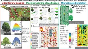
城市发展和扩张产生的城市气候和城市热岛效应对人类健康和福祉产生重大影响。城市森林在调节城市气候方面发挥着至关重要的作用,通过遮荫和蒸散作用使周围环境降温,以及许多基本的生态系统服务。不同的人类社区具有不同的城市森林丰度、组成和模式,从而导致不同的降温效果和小气候结果。虽然普遍的共识是种植更多的树木会产生更大的效益,但越来越需要在更细粒度的尺度上了解和记录森林的各种分类、结构和生物物理特性。这种理解对于预测和比较不同社区的小气候条件至关重要。在这项研究中,我们利用高密度的机载点云数据(58脉冲/ m2)根据树木的垂直和内部结构来区分树木。我们为美国俄勒冈州波特兰市两个社会经济不同社区的所有树木创建了一个树家族和大小分类图。随机森林分类器使用激光雷达派生的度量,将所有树木对象分为7类,总体准确率为67.1%。利用分类属性,我们模拟和比较了这些森林的综合空气温度冷却效应,并使用基于对象的ENVI-met模型测试了不同的树木组成情景。模拟结果表明,较富裕的社区比较不富裕的社区(平均低0.23 K)经历了1.5米以上地面气温的显著下降。如果目前的森林进化趋势持续下去,这种利益差距可能会进一步扩大。本研究展示了从生成基于对象的城市树木知识到城市森林复合效应的高空间分辨率小气候模拟的综合工作流程。该方法有助于实际的城市森林质量监测和评价,补充城市规划和管理实践,优化城市森林,促进跨社区生态系统服务公平。
本文章由计算机程序翻译,如有差异,请以英文原文为准。

Community-scale microclimate simulation using Airborne Laser Scanning and object-based urban tree classification

Community-scale microclimate simulation using Airborne Laser Scanning and object-based urban tree classification
Urban climate and urban heat island effects, resulting from urban development and expansion, significantly impact human health and well-being. Urban forests play a vital role in regulating urban climate by cooling the ambient environment through shade and evapotranspiration, among many essential ecosystem services. Different human communities have distinct abundances, compositions, and patterns of urban forests, leading to varied cooling effectiveness and microclimate outcomes. While the general consensus is that planting more trees yields greater benefits, there is an increasing need to understand and document the forests’ varied taxonomical, structural, and biophysical properties at a more granular scale. This understanding is crucial to predicting and comparing the consequent microclimate conditions across communities. In this study, we utilize high-density airborne point cloud data (58 pulses per m2) to differentiate trees based on their vertical and internal structures. We create a tree family and size classification map for all trees in two socioeconomically distinct communities in Portland, Oregon, USA. The Random Forest classifier, using Lidar-derived metrics, classifies all tree objects into seven classes with an overall accuracy of 67.1 %. Using the classified properties, we simulate and compare these forests’ combined air temperature cooling effects and test alternative tree composition scenarios with the object-based ENVI-met model. The simulation results indicate that wealthier communities experience a more significant reduction in 1.5-meter-above-ground air temperature than less wealthy communities (0.23 K cooler on average). This disparity in benefits is likely to widen further if current forest evolution trends persist. This study demonstrates a comprehensive workflow from generating object-based knowledge on urban trees to high spatial resolution microclimate simulation of the urban forests’ composite effects. This approach can aid in practical urban forest quality monitoring and evaluation, supplement urban planning and management practices, and optimize the urban forest to facilitate cross-community ecosystem services equity.
求助全文
通过发布文献求助,成功后即可免费获取论文全文。 去求助
来源期刊
Landscape and Urban Planning
Landscape and Urban Planning 环境科学-生态学
CiteScore
15.20
自引率
6.60%
发文量
232
审稿时长
6 months
期刊介绍: Landscape and Urban Planning is an international journal that aims to enhance our understanding of landscapes and promote sustainable solutions for landscape change. The journal focuses on landscapes as complex social-ecological systems that encompass various spatial and temporal dimensions. These landscapes possess aesthetic, natural, and cultural qualities that are valued by individuals in different ways, leading to actions that alter the landscape. With increasing urbanization and the need for ecological and cultural sensitivity at various scales, a multidisciplinary approach is necessary to comprehend and align social and ecological values for landscape sustainability. The journal believes that combining landscape science with planning and design can yield positive outcomes for both people and nature.
×
引用
GB/T 7714-2015
复制
MLA
复制
APA
复制
导出至
BibTeX EndNote RefMan NoteFirst NoteExpress
×
提示
您的信息不完整,为了账户安全,请先补充。
现在去补充
×
提示
您因"违规操作"
具体请查看互助需知
我知道了
×
提示
确定
请完成安全验证×
copy
已复制链接
快去分享给好友吧!
我知道了
右上角分享
点击右上角分享
0
联系我们:info@booksci.cn Book学术提供免费学术资源搜索服务,方便国内外学者检索中英文文献。致力于提供最便捷和优质的服务体验。 Copyright © 2023 布克学术 All rights reserved.
京ICP备2023020795号-1
ghs 京公网安备 11010802042870号
Book学术文献互助
Book学术文献互助群
群 号:604180095
Book学术官方微信