Elisabeth Glück, Stéphane Garambois, Jean Vandemeulebrouck, Titouan Muzellec, Jean Virieux, Anette K. Mortensen, Egill Árni Gudnason, Thorbjörg Ágústsdóttir
{"title":"冰岛北部-东部Krafla地区地震活动模式和多尺度成像","authors":"Elisabeth Glück, Stéphane Garambois, Jean Vandemeulebrouck, Titouan Muzellec, Jean Virieux, Anette K. Mortensen, Egill Árni Gudnason, Thorbjörg Ágústsdóttir","doi":"10.1029/2024JB030425","DOIUrl":null,"url":null,"abstract":"<p>Krafla, one of five central volcanoes of the Northern Volcanic Zone in Iceland, is utilized for geothermal energy production. Due to scientific and industrial interests, the volcano and its geothermal system have been imaged and monitored with various geophysical methods over the last decades leading to a better knowledge of its complex geological setting. Nonetheless, the unexpected encounter of magma at relatively shallow depths during drilling of the IDDP-1 well in 2009 proved that imaging small-scale structures remains challenging in such heterogeneous geological settings. With data from a local permanent 12 station seismic network owned by Landsvirkjun and operated by Iceland GeoSurvey since 2013, and a dense temporary network of 98 seismic nodes deployed for one month in 2022 in the center of Krafla caldera, we conducted a multi-scale analysis based on local earthquake tomography. This analysis enables us to identify small-scale velocity structures and improve earthquake locations. The newly obtained high-resolution 3D models for P- and S-wave velocities offer a glimpse into the subsurface structure of the volcanic system with both wave types being responsive to distinct rock/fluid properties. The relocated seismic activity highlights active structures pinpointed through the tomography, in particular the seismogenic zone at the boundary of high to low <span></span><math>\n <semantics>\n <mrow>\n <msub>\n <mi>V</mi>\n <mi>p</mi>\n </msub>\n <mo>/</mo>\n <msub>\n <mi>V</mi>\n <mi>s</mi>\n </msub>\n </mrow>\n <annotation> ${V}_{p}/{V}_{s}$</annotation>\n </semantics></math> ratios, close to where magma was repeatedly encountered. By comparing the newly obtained high-resolution velocity models with available well log data, such as formation temperature, we aim to enhance the understanding of the interconnected volcanic and geothermal systems in areas lacking in situ measurements.</p>","PeriodicalId":15864,"journal":{"name":"Journal of Geophysical Research: Solid Earth","volume":"130 5","pages":""},"PeriodicalIF":4.1000,"publicationDate":"2025-05-24","publicationTypes":"Journal Article","fieldsOfStudy":null,"isOpenAccess":false,"openAccessPdf":"https://onlinelibrary.wiley.com/doi/epdf/10.1029/2024JB030425","citationCount":"0","resultStr":"{\"title\":\"Seismicity Patterns and Multi-Scale Imaging of Krafla, N–E Iceland, With Local Earthquake Tomography\",\"authors\":\"Elisabeth Glück, Stéphane Garambois, Jean Vandemeulebrouck, Titouan Muzellec, Jean Virieux, Anette K. Mortensen, Egill Árni Gudnason, Thorbjörg Ágústsdóttir\",\"doi\":\"10.1029/2024JB030425\",\"DOIUrl\":null,\"url\":null,\"abstract\":\"<p>Krafla, one of five central volcanoes of the Northern Volcanic Zone in Iceland, is utilized for geothermal energy production. Due to scientific and industrial interests, the volcano and its geothermal system have been imaged and monitored with various geophysical methods over the last decades leading to a better knowledge of its complex geological setting. Nonetheless, the unexpected encounter of magma at relatively shallow depths during drilling of the IDDP-1 well in 2009 proved that imaging small-scale structures remains challenging in such heterogeneous geological settings. With data from a local permanent 12 station seismic network owned by Landsvirkjun and operated by Iceland GeoSurvey since 2013, and a dense temporary network of 98 seismic nodes deployed for one month in 2022 in the center of Krafla caldera, we conducted a multi-scale analysis based on local earthquake tomography. This analysis enables us to identify small-scale velocity structures and improve earthquake locations. The newly obtained high-resolution 3D models for P- and S-wave velocities offer a glimpse into the subsurface structure of the volcanic system with both wave types being responsive to distinct rock/fluid properties. The relocated seismic activity highlights active structures pinpointed through the tomography, in particular the seismogenic zone at the boundary of high to low <span></span><math>\\n <semantics>\\n <mrow>\\n <msub>\\n <mi>V</mi>\\n <mi>p</mi>\\n </msub>\\n <mo>/</mo>\\n <msub>\\n <mi>V</mi>\\n <mi>s</mi>\\n </msub>\\n </mrow>\\n <annotation> ${V}_{p}/{V}_{s}$</annotation>\\n </semantics></math> ratios, close to where magma was repeatedly encountered. By comparing the newly obtained high-resolution velocity models with available well log data, such as formation temperature, we aim to enhance the understanding of the interconnected volcanic and geothermal systems in areas lacking in situ measurements.</p>\",\"PeriodicalId\":15864,\"journal\":{\"name\":\"Journal of Geophysical Research: Solid Earth\",\"volume\":\"130 5\",\"pages\":\"\"},\"PeriodicalIF\":4.1000,\"publicationDate\":\"2025-05-24\",\"publicationTypes\":\"Journal Article\",\"fieldsOfStudy\":null,\"isOpenAccess\":false,\"openAccessPdf\":\"https://onlinelibrary.wiley.com/doi/epdf/10.1029/2024JB030425\",\"citationCount\":\"0\",\"resultStr\":null,\"platform\":\"Semanticscholar\",\"paperid\":null,\"PeriodicalName\":\"Journal of Geophysical Research: Solid Earth\",\"FirstCategoryId\":\"89\",\"ListUrlMain\":\"https://agupubs.onlinelibrary.wiley.com/doi/10.1029/2024JB030425\",\"RegionNum\":2,\"RegionCategory\":\"地球科学\",\"ArticlePicture\":[],\"TitleCN\":null,\"AbstractTextCN\":null,\"PMCID\":null,\"EPubDate\":\"\",\"PubModel\":\"\",\"JCR\":\"Q1\",\"JCRName\":\"GEOCHEMISTRY & GEOPHYSICS\",\"Score\":null,\"Total\":0}","platform":"Semanticscholar","paperid":null,"PeriodicalName":"Journal of Geophysical Research: Solid Earth","FirstCategoryId":"89","ListUrlMain":"https://agupubs.onlinelibrary.wiley.com/doi/10.1029/2024JB030425","RegionNum":2,"RegionCategory":"地球科学","ArticlePicture":[],"TitleCN":null,"AbstractTextCN":null,"PMCID":null,"EPubDate":"","PubModel":"","JCR":"Q1","JCRName":"GEOCHEMISTRY & GEOPHYSICS","Score":null,"Total":0}
引用次数: 0
摘要
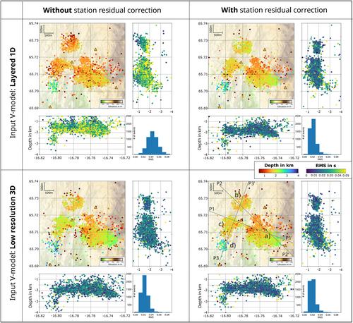
克拉夫拉火山是冰岛北部火山带的五座中心火山之一,被用来生产地热能。由于科学和工业的兴趣,在过去的几十年里,人们用各种地球物理方法对火山及其地热系统进行了成像和监测,从而更好地了解了其复杂的地质环境。尽管如此,2009年钻探IDDP-1井时,在相对较浅的深度意外发现了岩浆,这证明了在这种非均质地质环境下,小尺度构造成像仍然具有挑战性。利用冰岛地质调查局自2013年以来运营的Landsvirkjun拥有的当地永久12站地震台网数据,以及2022年在Krafla火山口中心部署的98个地震节点的密集临时台网数据,我们进行了基于当地地震层析成像的多尺度分析。这种分析使我们能够识别小尺度速度结构并改进地震位置。新获得的纵波和横波速度的高分辨率3D模型可以让我们一窥火山系统的地下结构,这两种波类型都对不同的岩石/流体性质有响应。重新定位的地震活动突出了通过层析成像确定的活动构造,特别是在高、低V p / V s ${V}_{p}/{V}_{s}$比值边界处的发震区。靠近反复遇到岩浆的地方。通过将新获得的高分辨率速度模型与现有的测井数据(如地层温度)进行比较,我们的目标是加强对缺乏原位测量的地区相互关联的火山和地热系统的理解。
Seismicity Patterns and Multi-Scale Imaging of Krafla, N–E Iceland, With Local Earthquake Tomography
Krafla, one of five central volcanoes of the Northern Volcanic Zone in Iceland, is utilized for geothermal energy production. Due to scientific and industrial interests, the volcano and its geothermal system have been imaged and monitored with various geophysical methods over the last decades leading to a better knowledge of its complex geological setting. Nonetheless, the unexpected encounter of magma at relatively shallow depths during drilling of the IDDP-1 well in 2009 proved that imaging small-scale structures remains challenging in such heterogeneous geological settings. With data from a local permanent 12 station seismic network owned by Landsvirkjun and operated by Iceland GeoSurvey since 2013, and a dense temporary network of 98 seismic nodes deployed for one month in 2022 in the center of Krafla caldera, we conducted a multi-scale analysis based on local earthquake tomography. This analysis enables us to identify small-scale velocity structures and improve earthquake locations. The newly obtained high-resolution 3D models for P- and S-wave velocities offer a glimpse into the subsurface structure of the volcanic system with both wave types being responsive to distinct rock/fluid properties. The relocated seismic activity highlights active structures pinpointed through the tomography, in particular the seismogenic zone at the boundary of high to low ratios, close to where magma was repeatedly encountered. By comparing the newly obtained high-resolution velocity models with available well log data, such as formation temperature, we aim to enhance the understanding of the interconnected volcanic and geothermal systems in areas lacking in situ measurements.
期刊介绍:
The Journal of Geophysical Research: Solid Earth serves as the premier publication for the breadth of solid Earth geophysics including (in alphabetical order): electromagnetic methods; exploration geophysics; geodesy and gravity; geodynamics, rheology, and plate kinematics; geomagnetism and paleomagnetism; hydrogeophysics; Instruments, techniques, and models; solid Earth interactions with the cryosphere, atmosphere, oceans, and climate; marine geology and geophysics; natural and anthropogenic hazards; near surface geophysics; petrology, geochemistry, and mineralogy; planet Earth physics and chemistry; rock mechanics and deformation; seismology; tectonophysics; and volcanology.
JGR: Solid Earth has long distinguished itself as the venue for publication of Research Articles backed solidly by data and as well as presenting theoretical and numerical developments with broad applications. Research Articles published in JGR: Solid Earth have had long-term impacts in their fields.
JGR: Solid Earth provides a venue for special issues and special themes based on conferences, workshops, and community initiatives. JGR: Solid Earth also publishes Commentaries on research and emerging trends in the field; these are commissioned by the editors, and suggestion are welcome.


 求助内容:
求助内容: 应助结果提醒方式:


