Marko Ferdian Salim, Tri Baskoro Tunggul Satoto, Danardono
{"title":"了解登革热的当地决定因素:印度尼西亚日惹的地理加权面板回归方法。","authors":"Marko Ferdian Salim, Tri Baskoro Tunggul Satoto, Danardono","doi":"10.1186/s41182-025-00734-4","DOIUrl":null,"url":null,"abstract":"<p><strong>Background: </strong>Dengue remains a major public health concern in tropical regions, including Yogyakarta, Indonesia. Understanding its spatiotemporal patterns and determinants is crucial for effective prevention strategies. This study explores the spatiotemporal determinants of dengue incidence and evaluates the spatial variability of predictors using a geographically weighted panel regression (GWPR) approach.</p><p><strong>Methods: </strong>This ecological study applied a spatiotemporal approach, analyzing dengue incidence across 78 sub-districts in Yogyakarta from 2017 to 2022. The dataset included meteorological variables (rainfall, temperature, humidity, wind speed, and atmospheric pressure), sociodemographic data (population density), and land-use characteristics (built-up areas, crops, trees, water bodies, and flooded vegetation). A GWPR model with a Fixed Exponential kernel was used to assess local variations in predictor influence.</p><p><strong>Results: </strong>The Fixed Exponential Kernel GWPR model showed strong explanatory power (Adjusted R<sup>2</sup> = 0.516, RSS = 43,097.96, AIC = 28,447.38). Local R-Square values ranged from 0.25 (low-performing sub-districts) to 0.75 (high-performing sub-districts), indicating significant spatial heterogeneity. Sub-districts such as Pakem, Cangkringan, and Girimulyo exhibited high local R<sup>2</sup> values (>0.75), indicating robust model performance, whereas Kalibawang showed lower values (<0.25), suggesting weaker predictive power. High-dengue-burden sub-districts, including Kasihan (0.743), Banguntapan (0.731), Sewon (0.716), Wonosari (0.623), and Wates (0.540), demonstrated stronger associations between dengue incidence and key predictors. In Wonosari, the most influential predictors were Rainfall Lag 1, Rainfall Lag 3, temperature, humidity, wind speed, atmospheric pressure, and land-use variables, while in Wates, significant predictors included Rainfall Lag 1, Rainfall Lag 3, atmospheric pressure, and land-use factors. Lower model performance in Sedayu and Kalibawang suggests the necessity of incorporating additional predictors such as sanitation conditions and vector control activities.</p><p><strong>Conclusions: </strong>The GWPR model provides valuable insights into the spatiotemporal dynamics of dengue incidence, emphasizing the role of localized predictors. Spatially adaptive prevention strategies focusing on high-risk areas are essential for effective dengue control in Yogyakarta and similar tropical regions.</p>","PeriodicalId":23311,"journal":{"name":"Tropical Medicine and Health","volume":"53 1","pages":"54"},"PeriodicalIF":3.5000,"publicationDate":"2025-04-14","publicationTypes":"Journal Article","fieldsOfStudy":null,"isOpenAccess":false,"openAccessPdf":"https://www.ncbi.nlm.nih.gov/pmc/articles/PMC11995575/pdf/","citationCount":"0","resultStr":"{\"title\":\"Understanding local determinants of dengue: a geographically weighted panel regression approach in Yogyakarta, Indonesia.\",\"authors\":\"Marko Ferdian Salim, Tri Baskoro Tunggul Satoto, Danardono\",\"doi\":\"10.1186/s41182-025-00734-4\",\"DOIUrl\":null,\"url\":null,\"abstract\":\"<p><strong>Background: </strong>Dengue remains a major public health concern in tropical regions, including Yogyakarta, Indonesia. Understanding its spatiotemporal patterns and determinants is crucial for effective prevention strategies. This study explores the spatiotemporal determinants of dengue incidence and evaluates the spatial variability of predictors using a geographically weighted panel regression (GWPR) approach.</p><p><strong>Methods: </strong>This ecological study applied a spatiotemporal approach, analyzing dengue incidence across 78 sub-districts in Yogyakarta from 2017 to 2022. The dataset included meteorological variables (rainfall, temperature, humidity, wind speed, and atmospheric pressure), sociodemographic data (population density), and land-use characteristics (built-up areas, crops, trees, water bodies, and flooded vegetation). A GWPR model with a Fixed Exponential kernel was used to assess local variations in predictor influence.</p><p><strong>Results: </strong>The Fixed Exponential Kernel GWPR model showed strong explanatory power (Adjusted R<sup>2</sup> = 0.516, RSS = 43,097.96, AIC = 28,447.38). Local R-Square values ranged from 0.25 (low-performing sub-districts) to 0.75 (high-performing sub-districts), indicating significant spatial heterogeneity. Sub-districts such as Pakem, Cangkringan, and Girimulyo exhibited high local R<sup>2</sup> values (>0.75), indicating robust model performance, whereas Kalibawang showed lower values (<0.25), suggesting weaker predictive power. High-dengue-burden sub-districts, including Kasihan (0.743), Banguntapan (0.731), Sewon (0.716), Wonosari (0.623), and Wates (0.540), demonstrated stronger associations between dengue incidence and key predictors. In Wonosari, the most influential predictors were Rainfall Lag 1, Rainfall Lag 3, temperature, humidity, wind speed, atmospheric pressure, and land-use variables, while in Wates, significant predictors included Rainfall Lag 1, Rainfall Lag 3, atmospheric pressure, and land-use factors. Lower model performance in Sedayu and Kalibawang suggests the necessity of incorporating additional predictors such as sanitation conditions and vector control activities.</p><p><strong>Conclusions: </strong>The GWPR model provides valuable insights into the spatiotemporal dynamics of dengue incidence, emphasizing the role of localized predictors. Spatially adaptive prevention strategies focusing on high-risk areas are essential for effective dengue control in Yogyakarta and similar tropical regions.</p>\",\"PeriodicalId\":23311,\"journal\":{\"name\":\"Tropical Medicine and Health\",\"volume\":\"53 1\",\"pages\":\"54\"},\"PeriodicalIF\":3.5000,\"publicationDate\":\"2025-04-14\",\"publicationTypes\":\"Journal Article\",\"fieldsOfStudy\":null,\"isOpenAccess\":false,\"openAccessPdf\":\"https://www.ncbi.nlm.nih.gov/pmc/articles/PMC11995575/pdf/\",\"citationCount\":\"0\",\"resultStr\":null,\"platform\":\"Semanticscholar\",\"paperid\":null,\"PeriodicalName\":\"Tropical Medicine and Health\",\"FirstCategoryId\":\"1085\",\"ListUrlMain\":\"https://doi.org/10.1186/s41182-025-00734-4\",\"RegionNum\":0,\"RegionCategory\":null,\"ArticlePicture\":[],\"TitleCN\":null,\"AbstractTextCN\":null,\"PMCID\":null,\"EPubDate\":\"\",\"PubModel\":\"\",\"JCR\":\"Q1\",\"JCRName\":\"TROPICAL MEDICINE\",\"Score\":null,\"Total\":0}","platform":"Semanticscholar","paperid":null,"PeriodicalName":"Tropical Medicine and Health","FirstCategoryId":"1085","ListUrlMain":"https://doi.org/10.1186/s41182-025-00734-4","RegionNum":0,"RegionCategory":null,"ArticlePicture":[],"TitleCN":null,"AbstractTextCN":null,"PMCID":null,"EPubDate":"","PubModel":"","JCR":"Q1","JCRName":"TROPICAL MEDICINE","Score":null,"Total":0}
Understanding local determinants of dengue: a geographically weighted panel regression approach in Yogyakarta, Indonesia.
Background: Dengue remains a major public health concern in tropical regions, including Yogyakarta, Indonesia. Understanding its spatiotemporal patterns and determinants is crucial for effective prevention strategies. This study explores the spatiotemporal determinants of dengue incidence and evaluates the spatial variability of predictors using a geographically weighted panel regression (GWPR) approach.
Methods: This ecological study applied a spatiotemporal approach, analyzing dengue incidence across 78 sub-districts in Yogyakarta from 2017 to 2022. The dataset included meteorological variables (rainfall, temperature, humidity, wind speed, and atmospheric pressure), sociodemographic data (population density), and land-use characteristics (built-up areas, crops, trees, water bodies, and flooded vegetation). A GWPR model with a Fixed Exponential kernel was used to assess local variations in predictor influence.
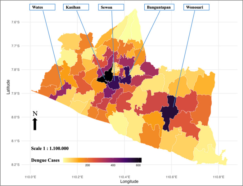
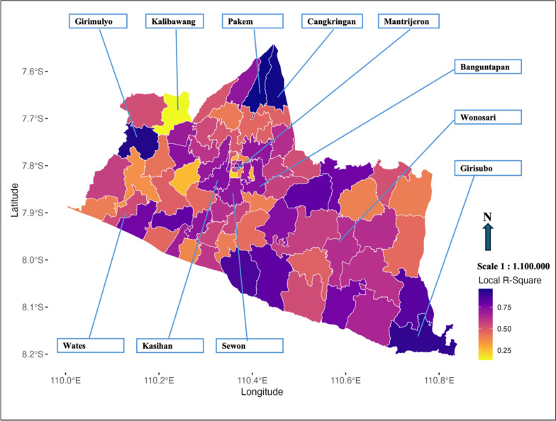
Results: The Fixed Exponential Kernel GWPR model showed strong explanatory power (Adjusted R2 = 0.516, RSS = 43,097.96, AIC = 28,447.38). Local R-Square values ranged from 0.25 (low-performing sub-districts) to 0.75 (high-performing sub-districts), indicating significant spatial heterogeneity. Sub-districts such as Pakem, Cangkringan, and Girimulyo exhibited high local R2 values (>0.75), indicating robust model performance, whereas Kalibawang showed lower values (<0.25), suggesting weaker predictive power. High-dengue-burden sub-districts, including Kasihan (0.743), Banguntapan (0.731), Sewon (0.716), Wonosari (0.623), and Wates (0.540), demonstrated stronger associations between dengue incidence and key predictors. In Wonosari, the most influential predictors were Rainfall Lag 1, Rainfall Lag 3, temperature, humidity, wind speed, atmospheric pressure, and land-use variables, while in Wates, significant predictors included Rainfall Lag 1, Rainfall Lag 3, atmospheric pressure, and land-use factors. Lower model performance in Sedayu and Kalibawang suggests the necessity of incorporating additional predictors such as sanitation conditions and vector control activities.
Conclusions: The GWPR model provides valuable insights into the spatiotemporal dynamics of dengue incidence, emphasizing the role of localized predictors. Spatially adaptive prevention strategies focusing on high-risk areas are essential for effective dengue control in Yogyakarta and similar tropical regions.
 求助内容:
求助内容: 应助结果提醒方式:


