Leiana Beyer, Tomoaki Miura, Kaʻuaʻoa Fraiola, Heather L. Spalding, Taylor M. Williams, Jonathan Martinez, Randall K. Kosaki, Keolohilani H. Lopes Jr.
{"title":"利用高分辨率卫星图像评估Papahānaumokuākea海洋国家保护区马纳威的一种令人讨厌的巨藻——软骨藻的空间分布。","authors":"Leiana Beyer, Tomoaki Miura, Kaʻuaʻoa Fraiola, Heather L. Spalding, Taylor M. Williams, Jonathan Martinez, Randall K. Kosaki, Keolohilani H. Lopes Jr.","doi":"10.1111/jpy.70025","DOIUrl":null,"url":null,"abstract":"<p>In 2019, a red macroalgal species, <i>Chondria tumulosa</i>, was discovered overgrowing native coral and algal species and changing the benthic communities of Manawai (Pearl and Hermes Atoll) in Papahānaumokuākea Marine National Monument (PMNM). The main objective of this study was to assess the spatial distribution of <i>C. tumulosa</i> across the forereef and backreef of Manawai using satellite remote sensing. WorldView-2 and -3 commercial high-resolution satellite images were obtained for a 12-year period from 2010 to 2021, from which, time-series animations were created. Previous studies reported that <i>C. tumulosa</i> appeared as distinctively dark features in satellite imagery with the first evidence of <i>C. tumulosa</i> in 2015. Thus, the animations were visually inspected to identify dark patches that became visible around the time of discovery and persisted in subsequent years. Field survey data of <i>C. tumulosa</i> cover collected in 2019–2021 were used to gain confidence in the identification of dark patches. Using those dark features as a reference and a support vector machine, the latest high-resolution satellite images from the 12-year period were classified into a map of distinctive dark patches suspected to be <i>C. tumulosa</i> with an average overall accuracy of 78%. Accuracy assessments of the classification results of <i>C. tumulosa</i> based on field survey data collected in 2019–2021 resulted in an overall accuracy of 79%. This study leverages the use of remote sensing to map a newly discovered alga in a remote area in the hopes of providing managers with a methodology to further monitor the species for long-term management.</p>","PeriodicalId":16831,"journal":{"name":"Journal of Phycology","volume":"61 3","pages":"722-736"},"PeriodicalIF":3.4000,"publicationDate":"2025-05-12","publicationTypes":"Journal Article","fieldsOfStudy":null,"isOpenAccess":false,"openAccessPdf":"https://onlinelibrary.wiley.com/doi/epdf/10.1111/jpy.70025","citationCount":"0","resultStr":"{\"title\":\"Assessment of the spatial distribution of Chondria tumulosa, a nuisance macroalga at Manawai in Papahānaumokuākea Marine National Monument using high-resolution satellite imagery\",\"authors\":\"Leiana Beyer, Tomoaki Miura, Kaʻuaʻoa Fraiola, Heather L. Spalding, Taylor M. Williams, Jonathan Martinez, Randall K. Kosaki, Keolohilani H. Lopes Jr.\",\"doi\":\"10.1111/jpy.70025\",\"DOIUrl\":null,\"url\":null,\"abstract\":\"<p>In 2019, a red macroalgal species, <i>Chondria tumulosa</i>, was discovered overgrowing native coral and algal species and changing the benthic communities of Manawai (Pearl and Hermes Atoll) in Papahānaumokuākea Marine National Monument (PMNM). The main objective of this study was to assess the spatial distribution of <i>C. tumulosa</i> across the forereef and backreef of Manawai using satellite remote sensing. WorldView-2 and -3 commercial high-resolution satellite images were obtained for a 12-year period from 2010 to 2021, from which, time-series animations were created. Previous studies reported that <i>C. tumulosa</i> appeared as distinctively dark features in satellite imagery with the first evidence of <i>C. tumulosa</i> in 2015. Thus, the animations were visually inspected to identify dark patches that became visible around the time of discovery and persisted in subsequent years. Field survey data of <i>C. tumulosa</i> cover collected in 2019–2021 were used to gain confidence in the identification of dark patches. Using those dark features as a reference and a support vector machine, the latest high-resolution satellite images from the 12-year period were classified into a map of distinctive dark patches suspected to be <i>C. tumulosa</i> with an average overall accuracy of 78%. Accuracy assessments of the classification results of <i>C. tumulosa</i> based on field survey data collected in 2019–2021 resulted in an overall accuracy of 79%. This study leverages the use of remote sensing to map a newly discovered alga in a remote area in the hopes of providing managers with a methodology to further monitor the species for long-term management.</p>\",\"PeriodicalId\":16831,\"journal\":{\"name\":\"Journal of Phycology\",\"volume\":\"61 3\",\"pages\":\"722-736\"},\"PeriodicalIF\":3.4000,\"publicationDate\":\"2025-05-12\",\"publicationTypes\":\"Journal Article\",\"fieldsOfStudy\":null,\"isOpenAccess\":false,\"openAccessPdf\":\"https://onlinelibrary.wiley.com/doi/epdf/10.1111/jpy.70025\",\"citationCount\":\"0\",\"resultStr\":null,\"platform\":\"Semanticscholar\",\"paperid\":null,\"PeriodicalName\":\"Journal of Phycology\",\"FirstCategoryId\":\"99\",\"ListUrlMain\":\"https://onlinelibrary.wiley.com/doi/10.1111/jpy.70025\",\"RegionNum\":3,\"RegionCategory\":\"生物学\",\"ArticlePicture\":[],\"TitleCN\":null,\"AbstractTextCN\":null,\"PMCID\":null,\"EPubDate\":\"\",\"PubModel\":\"\",\"JCR\":\"Q1\",\"JCRName\":\"MARINE & FRESHWATER BIOLOGY\",\"Score\":null,\"Total\":0}","platform":"Semanticscholar","paperid":null,"PeriodicalName":"Journal of Phycology","FirstCategoryId":"99","ListUrlMain":"https://onlinelibrary.wiley.com/doi/10.1111/jpy.70025","RegionNum":3,"RegionCategory":"生物学","ArticlePicture":[],"TitleCN":null,"AbstractTextCN":null,"PMCID":null,"EPubDate":"","PubModel":"","JCR":"Q1","JCRName":"MARINE & FRESHWATER BIOLOGY","Score":null,"Total":0}
Assessment of the spatial distribution of Chondria tumulosa, a nuisance macroalga at Manawai in Papahānaumokuākea Marine National Monument using high-resolution satellite imagery
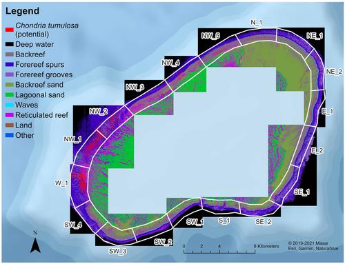
In 2019, a red macroalgal species, Chondria tumulosa, was discovered overgrowing native coral and algal species and changing the benthic communities of Manawai (Pearl and Hermes Atoll) in Papahānaumokuākea Marine National Monument (PMNM). The main objective of this study was to assess the spatial distribution of C. tumulosa across the forereef and backreef of Manawai using satellite remote sensing. WorldView-2 and -3 commercial high-resolution satellite images were obtained for a 12-year period from 2010 to 2021, from which, time-series animations were created. Previous studies reported that C. tumulosa appeared as distinctively dark features in satellite imagery with the first evidence of C. tumulosa in 2015. Thus, the animations were visually inspected to identify dark patches that became visible around the time of discovery and persisted in subsequent years. Field survey data of C. tumulosa cover collected in 2019–2021 were used to gain confidence in the identification of dark patches. Using those dark features as a reference and a support vector machine, the latest high-resolution satellite images from the 12-year period were classified into a map of distinctive dark patches suspected to be C. tumulosa with an average overall accuracy of 78%. Accuracy assessments of the classification results of C. tumulosa based on field survey data collected in 2019–2021 resulted in an overall accuracy of 79%. This study leverages the use of remote sensing to map a newly discovered alga in a remote area in the hopes of providing managers with a methodology to further monitor the species for long-term management.
期刊介绍:
The Journal of Phycology was founded in 1965 by the Phycological Society of America. All aspects of basic and applied research on algae are included to provide a common medium for the ecologist, physiologist, cell biologist, molecular biologist, morphologist, oceanographer, taxonomist, geneticist, and biochemist. The Journal also welcomes research that emphasizes algal interactions with other organisms and the roles of algae as components of natural ecosystems.
All aspects of basic and applied research on algae are included to provide a common medium for the ecologist, physiologist, cell biologist, molecular biologist, morphologist, oceanographer, acquaculturist, systematist, geneticist, and biochemist. The Journal also welcomes research that emphasizes algal interactions with other organisms and the roles of algae as components of natural ecosystems.
 求助内容:
求助内容: 应助结果提醒方式:


