利用集成机器学习识别影响产量空间格局的关键土壤和景观因素,用于划定管理区
IF 8.9
1区 农林科学
Q1 AGRICULTURE, MULTIDISCIPLINARY
引用次数: 0
摘要
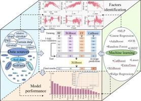
将农田划分为几个同质管理区域(MZs)是一种很有前途的精准农业策略。以往的研究表明,应结合产量空间趋势图(YST)、产量时间稳定性图和土壤景观因子进行MZ圈定。土壤景观因子对作物产量有显著影响,但如何识别特定的土壤景观因子用于MZ划定的研究还不够充分。本研究的目的是:1)评估不同机器学习(ML)算法预测YST的性能;2)比较可获得的土壤和景观数据与不同土壤遥感数据解释YST变异的有效性;3)利用基于不同数据源的集合叠加回归模型识别影响YST的关键土壤景观因子;4)基于自由数据集对识别出的关键因子进行评价,用于MZ圈定。该研究基于美国明尼苏达州西部的两个玉米(Zea mays L.)-大豆(Glycine max L.)轮作田,涵盖2014年至2023年的数据。11个ML模型,以及结合堆叠技术和SHapley加性解释(SHAP)值的集成模型,被训练和评估用于预测YST和识别关键因素。采用递归特征消去法从多个数据集中确定最优变量,包括自由数据、自由数据与SoilOptix传感器数据结合、自由数据与Veris传感器数据结合以及组合的完整数据集。结果表明,与其他ML模型(R2 = 0.02-0.73)相比,堆叠模型始终具有最高的准确性(R2 = 0.54-0.79)。虽然整合SoilOptix和Veris传感器数据提高了模型性能(R2 = 0.66-0.79),但仅使用免费数据集就足以解释54% - 72%的YST变异性,使该方法对农民来说既具有成本效益又可扩展。影响YST的关键因子在田间不同,在田间1中,相对高程、坡度和土壤亮度指数最为重要,而在田间2中,土壤有机质、相对高程和容重更为关键。在Field 1和Field 2中,仅使用10个和3个关键因子就可以分别解释大约51%和64%的YST变异性。为了提高作物生产力、资源利用效率、经济盈利能力和环境可持续性,需要开展更多的研究,以制定切实有效的MZ划定方法和区域管理策略。本文章由计算机程序翻译,如有差异,请以英文原文为准。
Identifying key soil and landscape factors influencing yield spatial patterns for management zone delineation using ensemble machine learning
Dividing a field into a few homogenous management zones (MZs) is a promising strategy for precision agriculture. Previous studies demonstrated that Yield Spatial Trend (YST) map, yield temporal stability map and soil-landscape factors should be combined for MZ delineation. The soil-landscape factors should significantly influence crop yield, but how to identify the specific soil-landscape factors for MZ delineation has not been sufficiently studied. The objectives of this study were to: 1) evaluate the performance of different Machine Learning (ML) algorithms for predicting YST; 2) compare the effectiveness of freely available soil and landscape data and different soil sensing data in explaining YST variability; 3) identify key soil landscape factors influencing YST using the ensemble stacking regression model based on various data sources; and 4) evaluate the identified key factors based on free dataset for MZ delineation. The study was based on two corn (Zea mays L.)-soybean (Glycine max L.) rotation fields in western Minnesota, USA, covering data from 2014 to 2023. Eleven ML models, along with an ensemble model combining stacking techniques and SHapley Additive Explanations (SHAP) values, were trained and evaluated for predicting YST and identifying key factors. Recursive feature elimination was employed to determine optimal variables from multiple datasets, including free data, free data combined with SoilOptix sensor data, free data combined with Veris sensor data, and the combined full datasets. The results demonstrated that the stacking model consistently achieved the highest accuracy (R2 = 0.54–0.79) compared to other ML models (R2 = 0.02–0.73). While integrating SoilOptix and Veris sensor data improved model performance (R2 = 0.66–0.79), using only the free dataset was sufficient to explain 54 %-72 % of the YST variability, making this approach both cost-effective and scalable for farmers. The key factors influencing YST varied between the two fields: relative elevation, slope, and soil brightness index were most important in Field 1, while soil organic matter, relative elevation, and bulk density were more critical in Field 2. Using only ten and three key factors in Field 1 and Field 2 could explain approximately 51 % and 64 % of the YST variability, respectively. More studies are needed to develop practical and efficient MZ delineation methods and zone-specific management strategies to improve crop productivity, resource use efficiency, economic profitability, and environmental sustainability.
求助全文
通过发布文献求助,成功后即可免费获取论文全文。
去求助
来源期刊

Computers and Electronics in Agriculture
工程技术-计算机:跨学科应用
CiteScore
15.30
自引率
14.50%
发文量
800
审稿时长
62 days
期刊介绍:
Computers and Electronics in Agriculture provides international coverage of advancements in computer hardware, software, electronic instrumentation, and control systems applied to agricultural challenges. Encompassing agronomy, horticulture, forestry, aquaculture, and animal farming, the journal publishes original papers, reviews, and applications notes. It explores the use of computers and electronics in plant or animal agricultural production, covering topics like agricultural soils, water, pests, controlled environments, and waste. The scope extends to on-farm post-harvest operations and relevant technologies, including artificial intelligence, sensors, machine vision, robotics, networking, and simulation modeling. Its companion journal, Smart Agricultural Technology, continues the focus on smart applications in production agriculture.
 求助内容:
求助内容: 应助结果提醒方式:


