Njifontawouo Ouzerou Mimche, Anatole Eugene Djieto Lordon, Charles Antoine Basseka, Christ Alain Nekuie Mouafo, Yannick Stephan Kengne
{"title":"利用 Landsat-8 Oli 和 SRTM 数据,在 Ebolowa 及周边地区应用遥感技术识别和分析地下水勘探线状地形","authors":"Njifontawouo Ouzerou Mimche, Anatole Eugene Djieto Lordon, Charles Antoine Basseka, Christ Alain Nekuie Mouafo, Yannick Stephan Kengne","doi":"10.1007/s12517-025-12249-7","DOIUrl":null,"url":null,"abstract":"<div><p>This research aimed to identify and analyse lineaments for groundwater exploration and delineate possible zones for groundwater exploitation. To achieve this, Landsat-8 OLI spectral bands as well as SRTM data covering the study area were obtained from the United States Geological Survey (USGS) website, from which fracture maps were produced. The extraction method of lineaments from remote sensing data required some pre-processing of the Landsat satellite image spectral bands to reduce the effect of the atmosphere and geometric distortions during data acquisition. The automatic lineament extraction was performed with the PCI Geomatica 2016 software for Landsat images and manually for SRTM on ArcGIS. Automatic lineament extraction was applied to the PC1 and PC2 bands of the Landsat-8 OLI image and each of the four shaded relief images of the SRTM images (N0°, N45°, N90°, and N135°). The results reveal 909 lineaments ranging from 21 m to 10.1 km, with an average length of 1.98 km and a standard deviation of 1.27. The lineaments on directional maps and rose diagrams show 8 directions with the predominance NE-SW. The secondary directions are NW–SE and WNW-ESE. The results are validated by the structural data measured in the field, the geological map of Cameroon, the hydrographic network, and the slope map. The results show an important role played by fractures in the occurrence of underground water in the study area. All this has enabled us to identify and characterise the potential areas for groundwater exploitation.\n</p></div>","PeriodicalId":476,"journal":{"name":"Arabian Journal of Geosciences","volume":"18 5","pages":""},"PeriodicalIF":1.8270,"publicationDate":"2025-04-12","publicationTypes":"Journal Article","fieldsOfStudy":null,"isOpenAccess":false,"openAccessPdf":"","citationCount":"0","resultStr":"{\"title\":\"Application of remote sensing in the identification and analysis of lineaments for groundwater exploration using Landsat-8 Oli and SRTM data in Ebolowa and environs\",\"authors\":\"Njifontawouo Ouzerou Mimche, Anatole Eugene Djieto Lordon, Charles Antoine Basseka, Christ Alain Nekuie Mouafo, Yannick Stephan Kengne\",\"doi\":\"10.1007/s12517-025-12249-7\",\"DOIUrl\":null,\"url\":null,\"abstract\":\"<div><p>This research aimed to identify and analyse lineaments for groundwater exploration and delineate possible zones for groundwater exploitation. To achieve this, Landsat-8 OLI spectral bands as well as SRTM data covering the study area were obtained from the United States Geological Survey (USGS) website, from which fracture maps were produced. The extraction method of lineaments from remote sensing data required some pre-processing of the Landsat satellite image spectral bands to reduce the effect of the atmosphere and geometric distortions during data acquisition. The automatic lineament extraction was performed with the PCI Geomatica 2016 software for Landsat images and manually for SRTM on ArcGIS. Automatic lineament extraction was applied to the PC1 and PC2 bands of the Landsat-8 OLI image and each of the four shaded relief images of the SRTM images (N0°, N45°, N90°, and N135°). The results reveal 909 lineaments ranging from 21 m to 10.1 km, with an average length of 1.98 km and a standard deviation of 1.27. The lineaments on directional maps and rose diagrams show 8 directions with the predominance NE-SW. The secondary directions are NW–SE and WNW-ESE. The results are validated by the structural data measured in the field, the geological map of Cameroon, the hydrographic network, and the slope map. The results show an important role played by fractures in the occurrence of underground water in the study area. All this has enabled us to identify and characterise the potential areas for groundwater exploitation.\\n</p></div>\",\"PeriodicalId\":476,\"journal\":{\"name\":\"Arabian Journal of Geosciences\",\"volume\":\"18 5\",\"pages\":\"\"},\"PeriodicalIF\":1.8270,\"publicationDate\":\"2025-04-12\",\"publicationTypes\":\"Journal Article\",\"fieldsOfStudy\":null,\"isOpenAccess\":false,\"openAccessPdf\":\"\",\"citationCount\":\"0\",\"resultStr\":null,\"platform\":\"Semanticscholar\",\"paperid\":null,\"PeriodicalName\":\"Arabian Journal of Geosciences\",\"FirstCategoryId\":\"1085\",\"ListUrlMain\":\"https://link.springer.com/article/10.1007/s12517-025-12249-7\",\"RegionNum\":0,\"RegionCategory\":null,\"ArticlePicture\":[],\"TitleCN\":null,\"AbstractTextCN\":null,\"PMCID\":null,\"EPubDate\":\"\",\"PubModel\":\"\",\"JCR\":\"Q2\",\"JCRName\":\"Earth and Planetary Sciences\",\"Score\":null,\"Total\":0}","platform":"Semanticscholar","paperid":null,"PeriodicalName":"Arabian Journal of Geosciences","FirstCategoryId":"1085","ListUrlMain":"https://link.springer.com/article/10.1007/s12517-025-12249-7","RegionNum":0,"RegionCategory":null,"ArticlePicture":[],"TitleCN":null,"AbstractTextCN":null,"PMCID":null,"EPubDate":"","PubModel":"","JCR":"Q2","JCRName":"Earth and Planetary Sciences","Score":null,"Total":0}
Application of remote sensing in the identification and analysis of lineaments for groundwater exploration using Landsat-8 Oli and SRTM data in Ebolowa and environs
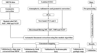
This research aimed to identify and analyse lineaments for groundwater exploration and delineate possible zones for groundwater exploitation. To achieve this, Landsat-8 OLI spectral bands as well as SRTM data covering the study area were obtained from the United States Geological Survey (USGS) website, from which fracture maps were produced. The extraction method of lineaments from remote sensing data required some pre-processing of the Landsat satellite image spectral bands to reduce the effect of the atmosphere and geometric distortions during data acquisition. The automatic lineament extraction was performed with the PCI Geomatica 2016 software for Landsat images and manually for SRTM on ArcGIS. Automatic lineament extraction was applied to the PC1 and PC2 bands of the Landsat-8 OLI image and each of the four shaded relief images of the SRTM images (N0°, N45°, N90°, and N135°). The results reveal 909 lineaments ranging from 21 m to 10.1 km, with an average length of 1.98 km and a standard deviation of 1.27. The lineaments on directional maps and rose diagrams show 8 directions with the predominance NE-SW. The secondary directions are NW–SE and WNW-ESE. The results are validated by the structural data measured in the field, the geological map of Cameroon, the hydrographic network, and the slope map. The results show an important role played by fractures in the occurrence of underground water in the study area. All this has enabled us to identify and characterise the potential areas for groundwater exploitation.
期刊介绍:
The Arabian Journal of Geosciences is the official journal of the Saudi Society for Geosciences and publishes peer-reviewed original and review articles on the entire range of Earth Science themes, focused on, but not limited to, those that have regional significance to the Middle East and the Euro-Mediterranean Zone.
Key topics therefore include; geology, hydrogeology, earth system science, petroleum sciences, geophysics, seismology and crustal structures, tectonics, sedimentology, palaeontology, metamorphic and igneous petrology, natural hazards, environmental sciences and sustainable development, geoarchaeology, geomorphology, paleo-environment studies, oceanography, atmospheric sciences, GIS and remote sensing, geodesy, mineralogy, volcanology, geochemistry and metallogenesis.

 求助内容:
求助内容: 应助结果提醒方式:


