一种用于综合水文建模的动态网格方案,以表示不断变化的景观
IF 8
1区 环境科学与生态学
Q1 ENVIRONMENTAL SCIENCES
引用次数: 0
摘要
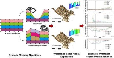
人类活动对水资源的影响已引起水资源管理部门、利益相关者和公众的高度关注。人为活动,如土地利用、农业实践和采矿作业的改变,对地表水和地下水系统的可持续性和质量产生深远影响。评估不断变化的工程环境对地表水和地下水系统的影响需要利用适应性景观模型,该模型可以考虑地表和地下地形、几何形状和材料特性的变化。通常,已采用全面综合的水文模型来分析由于气候条件或取水的变化而引起的水的可利用性和质量的变化。在这种情况下,模型的结构框架保持不变,在模拟过程中通常对边界条件或材料参数化进行调整。然而,在城市发展、工业扩张和露天采矿等重大景观变化的情况下,由于固定模型几何形状在捕捉地表水和地下水系统的动态变化方面的局限性,在模型中准确地表示这些变化变得具有挑战性。本文提出了一种结合地表-地下模型HydroGeoSphere的动态网格划分方案。通过与静态山坡条件下地下水渗流模式的比较,验证了景观演化模型的准确性,与前人的研究结果一致。此外,我们提出了动态网格方案的概念验证应用,该方案位于加拿大大河流域内的下尼特河子流域的综合露天矿场地,有效地捕获了地表-地下综合模型中随时间变化的工程配置。本文章由计算机程序翻译,如有差异,请以英文原文为准。
A dynamic meshing scheme for integrated hydrologic modeling to represent evolving landscapes
The influence of human activities on water resources has gained significant attention from water resource regulatory authorities, stakeholders, and the public. Anthropogenic activities, such as alterations in land use, agricultural practices, and mining operations, have a profound impact on the sustainability and quality of both surface water and groundwater systems. Evaluating the influence of a continually evolving engineered environment on surface water and groundwater systems demands the utilization of adaptive landscape models that can consider changing surface and subsurface topography, geometry, and material properties. Typically, fully integrated hydrologic models have been employed to analyze alterations in water availability and quality resulting from variations in climatic conditions or water extraction. In such scenarios, the structural framework of the model remains constant, with adjustments typically made to boundary conditions or material parameterizations during simulations. However, in cases of substantial landscape transformations, such as urban development, industrial expansion, and open-pit mining, accurately representing these changes in models becomes challenging due to the limitations of fixed model geometry in capturing dynamic shifts in surface water and groundwater systems. This study presents a dynamic meshing scheme integrated into the surface-subsurface model, HydroGeoSphere. The accuracy of the evolving-landscape model was verified by comparing it against groundwater seepage patterns in static hillslope conditions, demonstrating strong agreement with previous studies. Furthermore, we present a proof-of-concept application of the dynamic meshing scheme in synthetic open-pit mining sites located in the Lower Nith River subwatershed within the Grand River Watershed, Canada, effectively capturing time-dependent engineering configurations in an integrated surface-subsurface model.
求助全文
通过发布文献求助,成功后即可免费获取论文全文。
去求助
来源期刊

Science of the Total Environment
环境科学-环境科学
CiteScore
17.60
自引率
10.20%
发文量
8726
审稿时长
2.4 months
期刊介绍:
The Science of the Total Environment is an international journal dedicated to scientific research on the environment and its interaction with humanity. It covers a wide range of disciplines and seeks to publish innovative, hypothesis-driven, and impactful research that explores the entire environment, including the atmosphere, lithosphere, hydrosphere, biosphere, and anthroposphere.
The journal's updated Aims & Scope emphasizes the importance of interdisciplinary environmental research with broad impact. Priority is given to studies that advance fundamental understanding and explore the interconnectedness of multiple environmental spheres. Field studies are preferred, while laboratory experiments must demonstrate significant methodological advancements or mechanistic insights with direct relevance to the environment.
 求助内容:
求助内容: 应助结果提醒方式:


