{"title":"基于LiDAR/IMU紧密耦合的3D LiDAR室外SLAM算法研究。","authors":"Darong Zhu, Qi Wang, Fangbin Wang, Xue Gong","doi":"10.1038/s41598-025-95730-3","DOIUrl":null,"url":null,"abstract":"<p><p>Aiming at the problems of easy loss of GPS positioning signals in outdoor environments and inaccurate map construction and position drift of traditional SLAM algorithms in outdoor scenes, this paper proposes a 3D LiDAR and inertial guidance tightly coupled SLAM algorithm. Firstly, inertial measurement unit (IMU) forward propagation is used to predict the current position, then backward propagation is used to compensate the motion distortion in the LiDAR data, and the point cloud alignment residuals are constructed based on the GICP algorithm, and then the iterative error state Kalman filter (IESKF) algorithm is utilized to complete the fusion of the point cloud residuals and the a priori position obtained from the forward propagation of the IMU to complete the state updating, and then the front-end fusion odometer is constructed. Next, a sparse voxel near-neighbor structure, iVox-based method, is employed to select key frames and construct local maps, leveraging spatial information during frame-map matching. This approach reduces the computational time required for point cloud alignment. Finally, the proposed algorithm is validated in real-world scenarios and on the outdoor open-source dataset KITTI. It is compared against mainstream algorithms, including FAST-LIO2 and LIO-SAM. The results demonstrate that the proposed approach achieves lower cumulative error, higher localization accuracy, and improved visualization with greater robustness in outdoor environments.</p>","PeriodicalId":21811,"journal":{"name":"Scientific Reports","volume":"15 1","pages":"11175"},"PeriodicalIF":3.9000,"publicationDate":"2025-04-01","publicationTypes":"Journal Article","fieldsOfStudy":null,"isOpenAccess":false,"openAccessPdf":"https://www.ncbi.nlm.nih.gov/pmc/articles/PMC11962141/pdf/","citationCount":"0","resultStr":"{\"title\":\"Research on 3D LiDAR outdoor SLAM algorithm based on LiDAR/IMU tight coupling.\",\"authors\":\"Darong Zhu, Qi Wang, Fangbin Wang, Xue Gong\",\"doi\":\"10.1038/s41598-025-95730-3\",\"DOIUrl\":null,\"url\":null,\"abstract\":\"<p><p>Aiming at the problems of easy loss of GPS positioning signals in outdoor environments and inaccurate map construction and position drift of traditional SLAM algorithms in outdoor scenes, this paper proposes a 3D LiDAR and inertial guidance tightly coupled SLAM algorithm. Firstly, inertial measurement unit (IMU) forward propagation is used to predict the current position, then backward propagation is used to compensate the motion distortion in the LiDAR data, and the point cloud alignment residuals are constructed based on the GICP algorithm, and then the iterative error state Kalman filter (IESKF) algorithm is utilized to complete the fusion of the point cloud residuals and the a priori position obtained from the forward propagation of the IMU to complete the state updating, and then the front-end fusion odometer is constructed. Next, a sparse voxel near-neighbor structure, iVox-based method, is employed to select key frames and construct local maps, leveraging spatial information during frame-map matching. This approach reduces the computational time required for point cloud alignment. Finally, the proposed algorithm is validated in real-world scenarios and on the outdoor open-source dataset KITTI. It is compared against mainstream algorithms, including FAST-LIO2 and LIO-SAM. The results demonstrate that the proposed approach achieves lower cumulative error, higher localization accuracy, and improved visualization with greater robustness in outdoor environments.</p>\",\"PeriodicalId\":21811,\"journal\":{\"name\":\"Scientific Reports\",\"volume\":\"15 1\",\"pages\":\"11175\"},\"PeriodicalIF\":3.9000,\"publicationDate\":\"2025-04-01\",\"publicationTypes\":\"Journal Article\",\"fieldsOfStudy\":null,\"isOpenAccess\":false,\"openAccessPdf\":\"https://www.ncbi.nlm.nih.gov/pmc/articles/PMC11962141/pdf/\",\"citationCount\":\"0\",\"resultStr\":null,\"platform\":\"Semanticscholar\",\"paperid\":null,\"PeriodicalName\":\"Scientific Reports\",\"FirstCategoryId\":\"103\",\"ListUrlMain\":\"https://doi.org/10.1038/s41598-025-95730-3\",\"RegionNum\":2,\"RegionCategory\":\"综合性期刊\",\"ArticlePicture\":[],\"TitleCN\":null,\"AbstractTextCN\":null,\"PMCID\":null,\"EPubDate\":\"\",\"PubModel\":\"\",\"JCR\":\"Q1\",\"JCRName\":\"MULTIDISCIPLINARY SCIENCES\",\"Score\":null,\"Total\":0}","platform":"Semanticscholar","paperid":null,"PeriodicalName":"Scientific Reports","FirstCategoryId":"103","ListUrlMain":"https://doi.org/10.1038/s41598-025-95730-3","RegionNum":2,"RegionCategory":"综合性期刊","ArticlePicture":[],"TitleCN":null,"AbstractTextCN":null,"PMCID":null,"EPubDate":"","PubModel":"","JCR":"Q1","JCRName":"MULTIDISCIPLINARY SCIENCES","Score":null,"Total":0}
Research on 3D LiDAR outdoor SLAM algorithm based on LiDAR/IMU tight coupling.
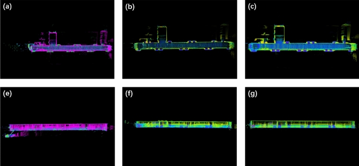
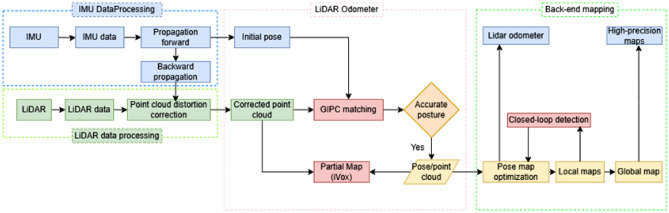
Aiming at the problems of easy loss of GPS positioning signals in outdoor environments and inaccurate map construction and position drift of traditional SLAM algorithms in outdoor scenes, this paper proposes a 3D LiDAR and inertial guidance tightly coupled SLAM algorithm. Firstly, inertial measurement unit (IMU) forward propagation is used to predict the current position, then backward propagation is used to compensate the motion distortion in the LiDAR data, and the point cloud alignment residuals are constructed based on the GICP algorithm, and then the iterative error state Kalman filter (IESKF) algorithm is utilized to complete the fusion of the point cloud residuals and the a priori position obtained from the forward propagation of the IMU to complete the state updating, and then the front-end fusion odometer is constructed. Next, a sparse voxel near-neighbor structure, iVox-based method, is employed to select key frames and construct local maps, leveraging spatial information during frame-map matching. This approach reduces the computational time required for point cloud alignment. Finally, the proposed algorithm is validated in real-world scenarios and on the outdoor open-source dataset KITTI. It is compared against mainstream algorithms, including FAST-LIO2 and LIO-SAM. The results demonstrate that the proposed approach achieves lower cumulative error, higher localization accuracy, and improved visualization with greater robustness in outdoor environments.
期刊介绍:
We publish original research from all areas of the natural sciences, psychology, medicine and engineering. You can learn more about what we publish by browsing our specific scientific subject areas below or explore Scientific Reports by browsing all articles and collections.
Scientific Reports has a 2-year impact factor: 4.380 (2021), and is the 6th most-cited journal in the world, with more than 540,000 citations in 2020 (Clarivate Analytics, 2021).
•Engineering
Engineering covers all aspects of engineering, technology, and applied science. It plays a crucial role in the development of technologies to address some of the world''s biggest challenges, helping to save lives and improve the way we live.
•Physical sciences
Physical sciences are those academic disciplines that aim to uncover the underlying laws of nature — often written in the language of mathematics. It is a collective term for areas of study including astronomy, chemistry, materials science and physics.
•Earth and environmental sciences
Earth and environmental sciences cover all aspects of Earth and planetary science and broadly encompass solid Earth processes, surface and atmospheric dynamics, Earth system history, climate and climate change, marine and freshwater systems, and ecology. It also considers the interactions between humans and these systems.
•Biological sciences
Biological sciences encompass all the divisions of natural sciences examining various aspects of vital processes. The concept includes anatomy, physiology, cell biology, biochemistry and biophysics, and covers all organisms from microorganisms, animals to plants.
•Health sciences
The health sciences study health, disease and healthcare. This field of study aims to develop knowledge, interventions and technology for use in healthcare to improve the treatment of patients.

 求助内容:
求助内容: 应助结果提醒方式:


