{"title":"和田河床渗透性和渗透水量随土壤粒度的变化由上游向下游变化。","authors":"Shuo Wang, Jianghui Zhang, Zheng Fang, Jianhui Du, Yungang Bai, Qiying Yu, Bangxin Ding","doi":"10.1038/s41598-025-93657-3","DOIUrl":null,"url":null,"abstract":"<p><p>Severe seepage presents a significant challenge to the sustainable management of water resources, and a lack of seepage data from the upper, middle, and lower reaches of the Hotan River hinders effective resource management. This study assessed the water infiltration rate in the riverbed using the double-ring method and evaluated the performance of four commonly used infiltration models. Results showed that infiltration rates were highest in the upper section, with permeability decreasing towards the banks. Water consumption, seepage volume, and seepage per unit river length decreased from upstream to downstream. Specifically, seepage volumes were greatest in the upstream section, followed by midstream and downstream. The seepage rate per unit riverbed was highest in the upstream section, followed by the midstream, and lowest in the downstream section. The mean sediment volume fractal dimension was 1.34, positively correlated with sand content, while higher clay and silt content resulted in finer textures and smaller fractal dimensions. These findings fill critical gaps in understanding water infiltration patterns and sediment characteristics in the Hotan River basin, providing essential data for water resource management and ecological protection. Among the models tested, the Kostiakov equation outperformed the Philip, Green-Ampt and Horton models in terms of accuracy and applicability.</p>","PeriodicalId":21811,"journal":{"name":"Scientific Reports","volume":"15 1","pages":"10472"},"PeriodicalIF":3.9000,"publicationDate":"2025-03-26","publicationTypes":"Journal Article","fieldsOfStudy":null,"isOpenAccess":false,"openAccessPdf":"https://www.ncbi.nlm.nih.gov/pmc/articles/PMC11947134/pdf/","citationCount":"0","resultStr":"{\"title\":\"Variations in Hotan riverbed permeability and seepage water amount by soil grain size changes from upstream to downstream.\",\"authors\":\"Shuo Wang, Jianghui Zhang, Zheng Fang, Jianhui Du, Yungang Bai, Qiying Yu, Bangxin Ding\",\"doi\":\"10.1038/s41598-025-93657-3\",\"DOIUrl\":null,\"url\":null,\"abstract\":\"<p><p>Severe seepage presents a significant challenge to the sustainable management of water resources, and a lack of seepage data from the upper, middle, and lower reaches of the Hotan River hinders effective resource management. This study assessed the water infiltration rate in the riverbed using the double-ring method and evaluated the performance of four commonly used infiltration models. Results showed that infiltration rates were highest in the upper section, with permeability decreasing towards the banks. Water consumption, seepage volume, and seepage per unit river length decreased from upstream to downstream. Specifically, seepage volumes were greatest in the upstream section, followed by midstream and downstream. The seepage rate per unit riverbed was highest in the upstream section, followed by the midstream, and lowest in the downstream section. The mean sediment volume fractal dimension was 1.34, positively correlated with sand content, while higher clay and silt content resulted in finer textures and smaller fractal dimensions. These findings fill critical gaps in understanding water infiltration patterns and sediment characteristics in the Hotan River basin, providing essential data for water resource management and ecological protection. Among the models tested, the Kostiakov equation outperformed the Philip, Green-Ampt and Horton models in terms of accuracy and applicability.</p>\",\"PeriodicalId\":21811,\"journal\":{\"name\":\"Scientific Reports\",\"volume\":\"15 1\",\"pages\":\"10472\"},\"PeriodicalIF\":3.9000,\"publicationDate\":\"2025-03-26\",\"publicationTypes\":\"Journal Article\",\"fieldsOfStudy\":null,\"isOpenAccess\":false,\"openAccessPdf\":\"https://www.ncbi.nlm.nih.gov/pmc/articles/PMC11947134/pdf/\",\"citationCount\":\"0\",\"resultStr\":null,\"platform\":\"Semanticscholar\",\"paperid\":null,\"PeriodicalName\":\"Scientific Reports\",\"FirstCategoryId\":\"103\",\"ListUrlMain\":\"https://doi.org/10.1038/s41598-025-93657-3\",\"RegionNum\":2,\"RegionCategory\":\"综合性期刊\",\"ArticlePicture\":[],\"TitleCN\":null,\"AbstractTextCN\":null,\"PMCID\":null,\"EPubDate\":\"\",\"PubModel\":\"\",\"JCR\":\"Q1\",\"JCRName\":\"MULTIDISCIPLINARY SCIENCES\",\"Score\":null,\"Total\":0}","platform":"Semanticscholar","paperid":null,"PeriodicalName":"Scientific Reports","FirstCategoryId":"103","ListUrlMain":"https://doi.org/10.1038/s41598-025-93657-3","RegionNum":2,"RegionCategory":"综合性期刊","ArticlePicture":[],"TitleCN":null,"AbstractTextCN":null,"PMCID":null,"EPubDate":"","PubModel":"","JCR":"Q1","JCRName":"MULTIDISCIPLINARY SCIENCES","Score":null,"Total":0}
Variations in Hotan riverbed permeability and seepage water amount by soil grain size changes from upstream to downstream.
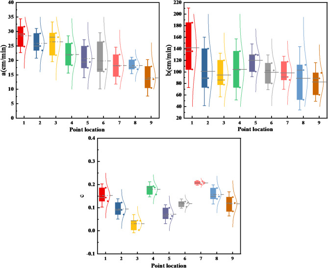
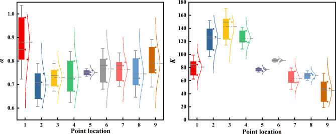
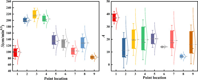
Severe seepage presents a significant challenge to the sustainable management of water resources, and a lack of seepage data from the upper, middle, and lower reaches of the Hotan River hinders effective resource management. This study assessed the water infiltration rate in the riverbed using the double-ring method and evaluated the performance of four commonly used infiltration models. Results showed that infiltration rates were highest in the upper section, with permeability decreasing towards the banks. Water consumption, seepage volume, and seepage per unit river length decreased from upstream to downstream. Specifically, seepage volumes were greatest in the upstream section, followed by midstream and downstream. The seepage rate per unit riverbed was highest in the upstream section, followed by the midstream, and lowest in the downstream section. The mean sediment volume fractal dimension was 1.34, positively correlated with sand content, while higher clay and silt content resulted in finer textures and smaller fractal dimensions. These findings fill critical gaps in understanding water infiltration patterns and sediment characteristics in the Hotan River basin, providing essential data for water resource management and ecological protection. Among the models tested, the Kostiakov equation outperformed the Philip, Green-Ampt and Horton models in terms of accuracy and applicability.
期刊介绍:
We publish original research from all areas of the natural sciences, psychology, medicine and engineering. You can learn more about what we publish by browsing our specific scientific subject areas below or explore Scientific Reports by browsing all articles and collections.
Scientific Reports has a 2-year impact factor: 4.380 (2021), and is the 6th most-cited journal in the world, with more than 540,000 citations in 2020 (Clarivate Analytics, 2021).
•Engineering
Engineering covers all aspects of engineering, technology, and applied science. It plays a crucial role in the development of technologies to address some of the world''s biggest challenges, helping to save lives and improve the way we live.
•Physical sciences
Physical sciences are those academic disciplines that aim to uncover the underlying laws of nature — often written in the language of mathematics. It is a collective term for areas of study including astronomy, chemistry, materials science and physics.
•Earth and environmental sciences
Earth and environmental sciences cover all aspects of Earth and planetary science and broadly encompass solid Earth processes, surface and atmospheric dynamics, Earth system history, climate and climate change, marine and freshwater systems, and ecology. It also considers the interactions between humans and these systems.
•Biological sciences
Biological sciences encompass all the divisions of natural sciences examining various aspects of vital processes. The concept includes anatomy, physiology, cell biology, biochemistry and biophysics, and covers all organisms from microorganisms, animals to plants.
•Health sciences
The health sciences study health, disease and healthcare. This field of study aims to develop knowledge, interventions and technology for use in healthcare to improve the treatment of patients.

 求助内容:
求助内容: 应助结果提醒方式:


