Joseph M. Eisaguirre, Madeleine G. Lohman, Graham G. Frye, Heather E. Johnson, Thomas V. Riecke, Perry J. Williams
{"title":"用稀疏点过程模型从遥测数据估计空间显式生存和死亡风险","authors":"Joseph M. Eisaguirre, Madeleine G. Lohman, Graham G. Frye, Heather E. Johnson, Thomas V. Riecke, Perry J. Williams","doi":"10.1111/ele.70092","DOIUrl":null,"url":null,"abstract":"<div>\n \n <p>Mortality risk for animals often varies spatially and can be linked to how animals use landscapes. While numerous studies collect telemetry data on animals, the focus is typically on the period when animals are alive, even though there is important information that could be gleaned about mortality risk. We introduce a thinned spatial point process (SPP) modelling framework that couples relative abundance and space use with a mortality process to formally treat the occurrence of mortality events across the landscape as a spatial process. We show how this model can be embedded in a hierarchical statistical framework and fit to telemetry data to make inferences about how spatial covariates drive both space use and mortality risk. We apply the method to two data sets to study the effects of roads and habitat on spatially explicit mortality risk: (1) VHF telemetry data collected for willow ptarmigan in Alaska, and (2) hourly GPS telemetry data collected for black bears in Colorado. These case studies demonstrate the applicability of this method for different species and data types, making it broadly useful in enabling inferences about the mechanisms influencing animal survival and spatial population processes while formally treating survival as a spatial process, especially as the development and implementation of joint analyses continue to progress.</p>\n </div>","PeriodicalId":161,"journal":{"name":"Ecology Letters","volume":"28 3","pages":""},"PeriodicalIF":7.9000,"publicationDate":"2025-03-03","publicationTypes":"Journal Article","fieldsOfStudy":null,"isOpenAccess":false,"openAccessPdf":"","citationCount":"0","resultStr":"{\"title\":\"Estimating Spatially Explicit Survival and Mortality Risk From Telemetry Data With Thinned Point Process Models\",\"authors\":\"Joseph M. Eisaguirre, Madeleine G. Lohman, Graham G. Frye, Heather E. Johnson, Thomas V. Riecke, Perry J. Williams\",\"doi\":\"10.1111/ele.70092\",\"DOIUrl\":null,\"url\":null,\"abstract\":\"<div>\\n \\n <p>Mortality risk for animals often varies spatially and can be linked to how animals use landscapes. While numerous studies collect telemetry data on animals, the focus is typically on the period when animals are alive, even though there is important information that could be gleaned about mortality risk. We introduce a thinned spatial point process (SPP) modelling framework that couples relative abundance and space use with a mortality process to formally treat the occurrence of mortality events across the landscape as a spatial process. We show how this model can be embedded in a hierarchical statistical framework and fit to telemetry data to make inferences about how spatial covariates drive both space use and mortality risk. We apply the method to two data sets to study the effects of roads and habitat on spatially explicit mortality risk: (1) VHF telemetry data collected for willow ptarmigan in Alaska, and (2) hourly GPS telemetry data collected for black bears in Colorado. These case studies demonstrate the applicability of this method for different species and data types, making it broadly useful in enabling inferences about the mechanisms influencing animal survival and spatial population processes while formally treating survival as a spatial process, especially as the development and implementation of joint analyses continue to progress.</p>\\n </div>\",\"PeriodicalId\":161,\"journal\":{\"name\":\"Ecology Letters\",\"volume\":\"28 3\",\"pages\":\"\"},\"PeriodicalIF\":7.9000,\"publicationDate\":\"2025-03-03\",\"publicationTypes\":\"Journal Article\",\"fieldsOfStudy\":null,\"isOpenAccess\":false,\"openAccessPdf\":\"\",\"citationCount\":\"0\",\"resultStr\":null,\"platform\":\"Semanticscholar\",\"paperid\":null,\"PeriodicalName\":\"Ecology Letters\",\"FirstCategoryId\":\"93\",\"ListUrlMain\":\"https://onlinelibrary.wiley.com/doi/10.1111/ele.70092\",\"RegionNum\":1,\"RegionCategory\":\"环境科学与生态学\",\"ArticlePicture\":[],\"TitleCN\":null,\"AbstractTextCN\":null,\"PMCID\":null,\"EPubDate\":\"\",\"PubModel\":\"\",\"JCR\":\"Q1\",\"JCRName\":\"ECOLOGY\",\"Score\":null,\"Total\":0}","platform":"Semanticscholar","paperid":null,"PeriodicalName":"Ecology Letters","FirstCategoryId":"93","ListUrlMain":"https://onlinelibrary.wiley.com/doi/10.1111/ele.70092","RegionNum":1,"RegionCategory":"环境科学与生态学","ArticlePicture":[],"TitleCN":null,"AbstractTextCN":null,"PMCID":null,"EPubDate":"","PubModel":"","JCR":"Q1","JCRName":"ECOLOGY","Score":null,"Total":0}
Estimating Spatially Explicit Survival and Mortality Risk From Telemetry Data With Thinned Point Process Models
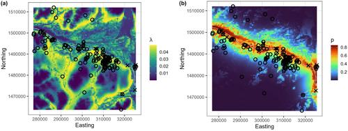
Mortality risk for animals often varies spatially and can be linked to how animals use landscapes. While numerous studies collect telemetry data on animals, the focus is typically on the period when animals are alive, even though there is important information that could be gleaned about mortality risk. We introduce a thinned spatial point process (SPP) modelling framework that couples relative abundance and space use with a mortality process to formally treat the occurrence of mortality events across the landscape as a spatial process. We show how this model can be embedded in a hierarchical statistical framework and fit to telemetry data to make inferences about how spatial covariates drive both space use and mortality risk. We apply the method to two data sets to study the effects of roads and habitat on spatially explicit mortality risk: (1) VHF telemetry data collected for willow ptarmigan in Alaska, and (2) hourly GPS telemetry data collected for black bears in Colorado. These case studies demonstrate the applicability of this method for different species and data types, making it broadly useful in enabling inferences about the mechanisms influencing animal survival and spatial population processes while formally treating survival as a spatial process, especially as the development and implementation of joint analyses continue to progress.
期刊介绍:
Ecology Letters serves as a platform for the rapid publication of innovative research in ecology. It considers manuscripts across all taxa, biomes, and geographic regions, prioritizing papers that investigate clearly stated hypotheses. The journal publishes concise papers of high originality and general interest, contributing to new developments in ecology. Purely descriptive papers and those that only confirm or extend previous results are discouraged.
 求助内容:
求助内容: 应助结果提醒方式:


