{"title":"利用气象雷达和机器学习优化泰国中部季风期间的降雨预测","authors":"Nattapon Mahavik, Apichaya Kangerd, Fatah Masthawee, Sarawut Arthayakun, Sarintip Tantanee","doi":"10.1007/s12665-025-12149-9","DOIUrl":null,"url":null,"abstract":"<div><p>Precise rainfall estimation is needed for disaster mitigation, water resource management, and sustainable agricultural practices, especially in tropical countries such as Thailand during the monsoon season. Although ground-based weather radar provides valuable spatial and temporal rainfall information, discrepancies can arise from biases related to attenuation, drop size variability, and beam shape. This study assesses the capability of machine learning (ML) algorithms to improve radar rainfall estimation by mitigating these biases. We evaluated five machine learning models—Linear Regression (LN), Decision Tree (DT), Random Forest (RF), Gradient Boosting (GBR), and XGBoost (XG)—utilizing gauged rainfall data and radar predictions from the Phitsanulok radar during four monsoon episodes in 2018. The investigation included three Z-R relationships—Marshall/Palmer, Rosenfeld, and Summer Deep Convective—evaluated over hourly and daily timescales, utilizing radar data at Constant Altitude Plan Position Indicator (CAPPI) heights. The results indicate more robust correlations for daily precipitation, especially concerning the ZR MP connection at CAPPI 2 km within a 120 km radar range. The RF model outperformed others in hourly rainfall prediction owing to its effective ensemble method for handling non-linear correlations, whilst the LN model excelled in daily rainfall due to its simplicity and stability in data aggregation. Furthermore, DT with ZR MP significantly reduced discrepancies in daily rainfall, whereas GBR shown enhanced efficacy for hourly rainfall. Machine learning models successfully surpassed traditional zero-regression relationships in diminishing Mean Field Bias (MFB) and improving predictive accuracy. This study illustrates the transformative capacity of machine learning models for enhancing radar rainfall estimation in monsoon-impacted areas. This study enhances forecasting, operational meteorology, and disaster preparedness in tropical regions by incorporating sophisticated machine learning algorithms into radar-based quantitative precipitation estimation (QPE).</p></div>","PeriodicalId":542,"journal":{"name":"Environmental Earth Sciences","volume":"84 5","pages":""},"PeriodicalIF":2.8000,"publicationDate":"2025-02-26","publicationTypes":"Journal Article","fieldsOfStudy":null,"isOpenAccess":false,"openAccessPdf":"","citationCount":"0","resultStr":"{\"title\":\"Optimizing rainfall prediction in central thailand with weather radar and machine learning during the monsoon\",\"authors\":\"Nattapon Mahavik, Apichaya Kangerd, Fatah Masthawee, Sarawut Arthayakun, Sarintip Tantanee\",\"doi\":\"10.1007/s12665-025-12149-9\",\"DOIUrl\":null,\"url\":null,\"abstract\":\"<div><p>Precise rainfall estimation is needed for disaster mitigation, water resource management, and sustainable agricultural practices, especially in tropical countries such as Thailand during the monsoon season. Although ground-based weather radar provides valuable spatial and temporal rainfall information, discrepancies can arise from biases related to attenuation, drop size variability, and beam shape. This study assesses the capability of machine learning (ML) algorithms to improve radar rainfall estimation by mitigating these biases. We evaluated five machine learning models—Linear Regression (LN), Decision Tree (DT), Random Forest (RF), Gradient Boosting (GBR), and XGBoost (XG)—utilizing gauged rainfall data and radar predictions from the Phitsanulok radar during four monsoon episodes in 2018. The investigation included three Z-R relationships—Marshall/Palmer, Rosenfeld, and Summer Deep Convective—evaluated over hourly and daily timescales, utilizing radar data at Constant Altitude Plan Position Indicator (CAPPI) heights. The results indicate more robust correlations for daily precipitation, especially concerning the ZR MP connection at CAPPI 2 km within a 120 km radar range. The RF model outperformed others in hourly rainfall prediction owing to its effective ensemble method for handling non-linear correlations, whilst the LN model excelled in daily rainfall due to its simplicity and stability in data aggregation. Furthermore, DT with ZR MP significantly reduced discrepancies in daily rainfall, whereas GBR shown enhanced efficacy for hourly rainfall. Machine learning models successfully surpassed traditional zero-regression relationships in diminishing Mean Field Bias (MFB) and improving predictive accuracy. This study illustrates the transformative capacity of machine learning models for enhancing radar rainfall estimation in monsoon-impacted areas. This study enhances forecasting, operational meteorology, and disaster preparedness in tropical regions by incorporating sophisticated machine learning algorithms into radar-based quantitative precipitation estimation (QPE).</p></div>\",\"PeriodicalId\":542,\"journal\":{\"name\":\"Environmental Earth Sciences\",\"volume\":\"84 5\",\"pages\":\"\"},\"PeriodicalIF\":2.8000,\"publicationDate\":\"2025-02-26\",\"publicationTypes\":\"Journal Article\",\"fieldsOfStudy\":null,\"isOpenAccess\":false,\"openAccessPdf\":\"\",\"citationCount\":\"0\",\"resultStr\":null,\"platform\":\"Semanticscholar\",\"paperid\":null,\"PeriodicalName\":\"Environmental Earth Sciences\",\"FirstCategoryId\":\"93\",\"ListUrlMain\":\"https://link.springer.com/article/10.1007/s12665-025-12149-9\",\"RegionNum\":4,\"RegionCategory\":\"环境科学与生态学\",\"ArticlePicture\":[],\"TitleCN\":null,\"AbstractTextCN\":null,\"PMCID\":null,\"EPubDate\":\"\",\"PubModel\":\"\",\"JCR\":\"Q3\",\"JCRName\":\"ENVIRONMENTAL SCIENCES\",\"Score\":null,\"Total\":0}","platform":"Semanticscholar","paperid":null,"PeriodicalName":"Environmental Earth Sciences","FirstCategoryId":"93","ListUrlMain":"https://link.springer.com/article/10.1007/s12665-025-12149-9","RegionNum":4,"RegionCategory":"环境科学与生态学","ArticlePicture":[],"TitleCN":null,"AbstractTextCN":null,"PMCID":null,"EPubDate":"","PubModel":"","JCR":"Q3","JCRName":"ENVIRONMENTAL SCIENCES","Score":null,"Total":0}
Optimizing rainfall prediction in central thailand with weather radar and machine learning during the monsoon
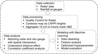
Precise rainfall estimation is needed for disaster mitigation, water resource management, and sustainable agricultural practices, especially in tropical countries such as Thailand during the monsoon season. Although ground-based weather radar provides valuable spatial and temporal rainfall information, discrepancies can arise from biases related to attenuation, drop size variability, and beam shape. This study assesses the capability of machine learning (ML) algorithms to improve radar rainfall estimation by mitigating these biases. We evaluated five machine learning models—Linear Regression (LN), Decision Tree (DT), Random Forest (RF), Gradient Boosting (GBR), and XGBoost (XG)—utilizing gauged rainfall data and radar predictions from the Phitsanulok radar during four monsoon episodes in 2018. The investigation included three Z-R relationships—Marshall/Palmer, Rosenfeld, and Summer Deep Convective—evaluated over hourly and daily timescales, utilizing radar data at Constant Altitude Plan Position Indicator (CAPPI) heights. The results indicate more robust correlations for daily precipitation, especially concerning the ZR MP connection at CAPPI 2 km within a 120 km radar range. The RF model outperformed others in hourly rainfall prediction owing to its effective ensemble method for handling non-linear correlations, whilst the LN model excelled in daily rainfall due to its simplicity and stability in data aggregation. Furthermore, DT with ZR MP significantly reduced discrepancies in daily rainfall, whereas GBR shown enhanced efficacy for hourly rainfall. Machine learning models successfully surpassed traditional zero-regression relationships in diminishing Mean Field Bias (MFB) and improving predictive accuracy. This study illustrates the transformative capacity of machine learning models for enhancing radar rainfall estimation in monsoon-impacted areas. This study enhances forecasting, operational meteorology, and disaster preparedness in tropical regions by incorporating sophisticated machine learning algorithms into radar-based quantitative precipitation estimation (QPE).
期刊介绍:
Environmental Earth Sciences is an international multidisciplinary journal concerned with all aspects of interaction between humans, natural resources, ecosystems, special climates or unique geographic zones, and the earth:
Water and soil contamination caused by waste management and disposal practices
Environmental problems associated with transportation by land, air, or water
Geological processes that may impact biosystems or humans
Man-made or naturally occurring geological or hydrological hazards
Environmental problems associated with the recovery of materials from the earth
Environmental problems caused by extraction of minerals, coal, and ores, as well as oil and gas, water and alternative energy sources
Environmental impacts of exploration and recultivation – Environmental impacts of hazardous materials
Management of environmental data and information in data banks and information systems
Dissemination of knowledge on techniques, methods, approaches and experiences to improve and remediate the environment
In pursuit of these topics, the geoscientific disciplines are invited to contribute their knowledge and experience. Major disciplines include: hydrogeology, hydrochemistry, geochemistry, geophysics, engineering geology, remediation science, natural resources management, environmental climatology and biota, environmental geography, soil science and geomicrobiology.

 求助内容:
求助内容: 应助结果提醒方式:


