{"title":"基于深度神经网络和地形信息的美国西部卫星降水估算偏差校正","authors":"Vu Dao, Claudia Jimenez Arellano, Phu Nguyen, Fahad Almutlaq, Kuolin Hsu, Soroosh Sorooshian","doi":"10.1029/2024JD042181","DOIUrl":null,"url":null,"abstract":"<p>Satellite-based precipitation products (SPPs) have gained popularity among researchers due to their utility in hydrologic studies. Several gridded satellite-based precipitation products with global coverage, such as the Integrated Multi-satellitE Retrievals for GPM (IMERG) and the Precipitation Estimation from Remotely Sensed Information using Artificial Neural Networks (PERSIANN) family of products, are available worldwide. However, the accuracy of these products may vary due to retrieval algorithms or geographic location. Numerous correction techniques have been implemented, and machine learning techniques, especially Deep Neural Networks, have proven to be the most effective in improving precipitation estimation. This study aims to investigate the performance of the PERSIANN-Dynamic Infrared Rain Rate near real-time product (PDIR-Now) in the Western U.S. and assess the effectiveness of three deep learning models including U-Net, Efficient-UNet, and a conditional Generative Adversarial Network (cGAN) in correcting biases present in the product. The developed models are expected to be more accurate than traditional methods, as they include digital elevation information and can resolve complex orographic enhancements in precipitation processes. This incorporation will mitigate the bias associated with SPPs, enabling further potential applications in water resource management. The findings revealed that the corrected results, utilizing the Efficient-UNet and cGAN models, surpassed the original PDIR-Now product and U-Net model across various statistical and categorical metrics at different temporal scales. This bias-correction scheme will enhance the assessment and understanding of precipitation patterns and can be used to improve the quality of precipitation estimates in other regions.</p>","PeriodicalId":15986,"journal":{"name":"Journal of Geophysical Research: Atmospheres","volume":"130 4","pages":""},"PeriodicalIF":3.4000,"publicationDate":"2025-02-24","publicationTypes":"Journal Article","fieldsOfStudy":null,"isOpenAccess":false,"openAccessPdf":"https://onlinelibrary.wiley.com/doi/epdf/10.1029/2024JD042181","citationCount":"0","resultStr":"{\"title\":\"Bias Correction of Satellite Precipitation Estimation Using Deep Neural Networks and Topographic Information Over the Western U.S.\",\"authors\":\"Vu Dao, Claudia Jimenez Arellano, Phu Nguyen, Fahad Almutlaq, Kuolin Hsu, Soroosh Sorooshian\",\"doi\":\"10.1029/2024JD042181\",\"DOIUrl\":null,\"url\":null,\"abstract\":\"<p>Satellite-based precipitation products (SPPs) have gained popularity among researchers due to their utility in hydrologic studies. Several gridded satellite-based precipitation products with global coverage, such as the Integrated Multi-satellitE Retrievals for GPM (IMERG) and the Precipitation Estimation from Remotely Sensed Information using Artificial Neural Networks (PERSIANN) family of products, are available worldwide. However, the accuracy of these products may vary due to retrieval algorithms or geographic location. Numerous correction techniques have been implemented, and machine learning techniques, especially Deep Neural Networks, have proven to be the most effective in improving precipitation estimation. This study aims to investigate the performance of the PERSIANN-Dynamic Infrared Rain Rate near real-time product (PDIR-Now) in the Western U.S. and assess the effectiveness of three deep learning models including U-Net, Efficient-UNet, and a conditional Generative Adversarial Network (cGAN) in correcting biases present in the product. The developed models are expected to be more accurate than traditional methods, as they include digital elevation information and can resolve complex orographic enhancements in precipitation processes. This incorporation will mitigate the bias associated with SPPs, enabling further potential applications in water resource management. The findings revealed that the corrected results, utilizing the Efficient-UNet and cGAN models, surpassed the original PDIR-Now product and U-Net model across various statistical and categorical metrics at different temporal scales. This bias-correction scheme will enhance the assessment and understanding of precipitation patterns and can be used to improve the quality of precipitation estimates in other regions.</p>\",\"PeriodicalId\":15986,\"journal\":{\"name\":\"Journal of Geophysical Research: Atmospheres\",\"volume\":\"130 4\",\"pages\":\"\"},\"PeriodicalIF\":3.4000,\"publicationDate\":\"2025-02-24\",\"publicationTypes\":\"Journal Article\",\"fieldsOfStudy\":null,\"isOpenAccess\":false,\"openAccessPdf\":\"https://onlinelibrary.wiley.com/doi/epdf/10.1029/2024JD042181\",\"citationCount\":\"0\",\"resultStr\":null,\"platform\":\"Semanticscholar\",\"paperid\":null,\"PeriodicalName\":\"Journal of Geophysical Research: Atmospheres\",\"FirstCategoryId\":\"89\",\"ListUrlMain\":\"https://agupubs.onlinelibrary.wiley.com/doi/10.1029/2024JD042181\",\"RegionNum\":2,\"RegionCategory\":\"地球科学\",\"ArticlePicture\":[],\"TitleCN\":null,\"AbstractTextCN\":null,\"PMCID\":null,\"EPubDate\":\"\",\"PubModel\":\"\",\"JCR\":\"Q2\",\"JCRName\":\"METEOROLOGY & ATMOSPHERIC SCIENCES\",\"Score\":null,\"Total\":0}","platform":"Semanticscholar","paperid":null,"PeriodicalName":"Journal of Geophysical Research: Atmospheres","FirstCategoryId":"89","ListUrlMain":"https://agupubs.onlinelibrary.wiley.com/doi/10.1029/2024JD042181","RegionNum":2,"RegionCategory":"地球科学","ArticlePicture":[],"TitleCN":null,"AbstractTextCN":null,"PMCID":null,"EPubDate":"","PubModel":"","JCR":"Q2","JCRName":"METEOROLOGY & ATMOSPHERIC SCIENCES","Score":null,"Total":0}
Bias Correction of Satellite Precipitation Estimation Using Deep Neural Networks and Topographic Information Over the Western U.S.
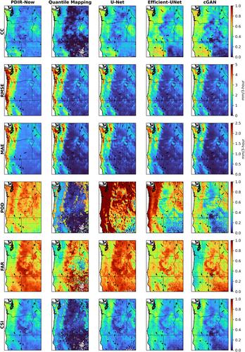
Satellite-based precipitation products (SPPs) have gained popularity among researchers due to their utility in hydrologic studies. Several gridded satellite-based precipitation products with global coverage, such as the Integrated Multi-satellitE Retrievals for GPM (IMERG) and the Precipitation Estimation from Remotely Sensed Information using Artificial Neural Networks (PERSIANN) family of products, are available worldwide. However, the accuracy of these products may vary due to retrieval algorithms or geographic location. Numerous correction techniques have been implemented, and machine learning techniques, especially Deep Neural Networks, have proven to be the most effective in improving precipitation estimation. This study aims to investigate the performance of the PERSIANN-Dynamic Infrared Rain Rate near real-time product (PDIR-Now) in the Western U.S. and assess the effectiveness of three deep learning models including U-Net, Efficient-UNet, and a conditional Generative Adversarial Network (cGAN) in correcting biases present in the product. The developed models are expected to be more accurate than traditional methods, as they include digital elevation information and can resolve complex orographic enhancements in precipitation processes. This incorporation will mitigate the bias associated with SPPs, enabling further potential applications in water resource management. The findings revealed that the corrected results, utilizing the Efficient-UNet and cGAN models, surpassed the original PDIR-Now product and U-Net model across various statistical and categorical metrics at different temporal scales. This bias-correction scheme will enhance the assessment and understanding of precipitation patterns and can be used to improve the quality of precipitation estimates in other regions.
期刊介绍:
JGR: Atmospheres publishes articles that advance and improve understanding of atmospheric properties and processes, including the interaction of the atmosphere with other components of the Earth system.


 求助内容:
求助内容: 应助结果提醒方式:


