{"title":"冠层高度模型与NAIP影像对。","authors":"Brady W Allred, Sarah E McCord, Scott L Morford","doi":"10.1038/s41597-025-04655-z","DOIUrl":null,"url":null,"abstract":"<p><p>Canopy height models (CHM) provide detailed environmental vertical structure information and are an important indicator and input for ecological and geospatial applications. These models are often spatiotemporally inconsistent, necessitating additional modeling to scale them in space and time. Yet, such scaling is hindered by a lack of spatially diverse data. To address this, we use United States Geological Survey 3D Elevation Program lidar data to produce 22,796,764 one meter resolution CHM chips, stratified across the dominant land covers of the conterminous United States. For each CHM, we pair a matching time-aligned aerial image from the United States Department of Agriculture National Agriculture Imagery Program. This dataset can be used to train models for large scale CHM production.</p>","PeriodicalId":21597,"journal":{"name":"Scientific Data","volume":"12 1","pages":"322"},"PeriodicalIF":6.9000,"publicationDate":"2025-02-22","publicationTypes":"Journal Article","fieldsOfStudy":null,"isOpenAccess":false,"openAccessPdf":"https://www.ncbi.nlm.nih.gov/pmc/articles/PMC11846907/pdf/","citationCount":"0","resultStr":"{\"title\":\"Canopy height model and NAIP imagery pairs across CONUS.\",\"authors\":\"Brady W Allred, Sarah E McCord, Scott L Morford\",\"doi\":\"10.1038/s41597-025-04655-z\",\"DOIUrl\":null,\"url\":null,\"abstract\":\"<p><p>Canopy height models (CHM) provide detailed environmental vertical structure information and are an important indicator and input for ecological and geospatial applications. These models are often spatiotemporally inconsistent, necessitating additional modeling to scale them in space and time. Yet, such scaling is hindered by a lack of spatially diverse data. To address this, we use United States Geological Survey 3D Elevation Program lidar data to produce 22,796,764 one meter resolution CHM chips, stratified across the dominant land covers of the conterminous United States. For each CHM, we pair a matching time-aligned aerial image from the United States Department of Agriculture National Agriculture Imagery Program. This dataset can be used to train models for large scale CHM production.</p>\",\"PeriodicalId\":21597,\"journal\":{\"name\":\"Scientific Data\",\"volume\":\"12 1\",\"pages\":\"322\"},\"PeriodicalIF\":6.9000,\"publicationDate\":\"2025-02-22\",\"publicationTypes\":\"Journal Article\",\"fieldsOfStudy\":null,\"isOpenAccess\":false,\"openAccessPdf\":\"https://www.ncbi.nlm.nih.gov/pmc/articles/PMC11846907/pdf/\",\"citationCount\":\"0\",\"resultStr\":null,\"platform\":\"Semanticscholar\",\"paperid\":null,\"PeriodicalName\":\"Scientific Data\",\"FirstCategoryId\":\"103\",\"ListUrlMain\":\"https://doi.org/10.1038/s41597-025-04655-z\",\"RegionNum\":2,\"RegionCategory\":\"综合性期刊\",\"ArticlePicture\":[],\"TitleCN\":null,\"AbstractTextCN\":null,\"PMCID\":null,\"EPubDate\":\"\",\"PubModel\":\"\",\"JCR\":\"Q1\",\"JCRName\":\"MULTIDISCIPLINARY SCIENCES\",\"Score\":null,\"Total\":0}","platform":"Semanticscholar","paperid":null,"PeriodicalName":"Scientific Data","FirstCategoryId":"103","ListUrlMain":"https://doi.org/10.1038/s41597-025-04655-z","RegionNum":2,"RegionCategory":"综合性期刊","ArticlePicture":[],"TitleCN":null,"AbstractTextCN":null,"PMCID":null,"EPubDate":"","PubModel":"","JCR":"Q1","JCRName":"MULTIDISCIPLINARY SCIENCES","Score":null,"Total":0}
Canopy height model and NAIP imagery pairs across CONUS.
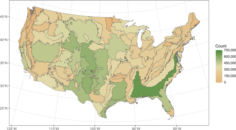
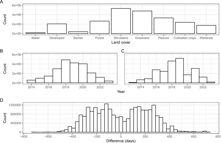
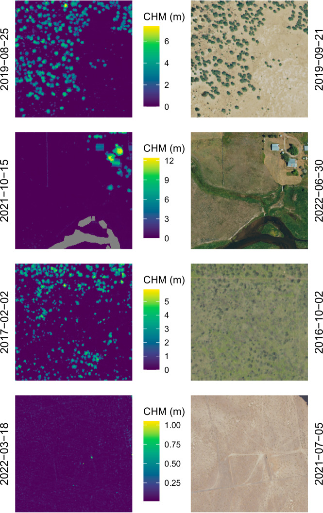
Canopy height models (CHM) provide detailed environmental vertical structure information and are an important indicator and input for ecological and geospatial applications. These models are often spatiotemporally inconsistent, necessitating additional modeling to scale them in space and time. Yet, such scaling is hindered by a lack of spatially diverse data. To address this, we use United States Geological Survey 3D Elevation Program lidar data to produce 22,796,764 one meter resolution CHM chips, stratified across the dominant land covers of the conterminous United States. For each CHM, we pair a matching time-aligned aerial image from the United States Department of Agriculture National Agriculture Imagery Program. This dataset can be used to train models for large scale CHM production.
期刊介绍:
Scientific Data is an open-access journal focused on data, publishing descriptions of research datasets and articles on data sharing across natural sciences, medicine, engineering, and social sciences. Its goal is to enhance the sharing and reuse of scientific data, encourage broader data sharing, and acknowledge those who share their data.
The journal primarily publishes Data Descriptors, which offer detailed descriptions of research datasets, including data collection methods and technical analyses validating data quality. These descriptors aim to facilitate data reuse rather than testing hypotheses or presenting new interpretations, methods, or in-depth analyses.
 求助内容:
求助内容: 应助结果提醒方式:


